
Evil
| coat of arms | Germany map | |
|---|---|---|

|
Coordinates: 53 ° 0 ' N , 7 ° 57' E |
|
| Basic data | ||
| State : | Lower Saxony | |
| County : | Cloppenburg | |
| Height : | 13 m above sea level NHN | |
| Area : | 100.17 km 2 | |
| Residents: | 8224 (Dec. 31, 2019) | |
| Population density : | 82 inhabitants per km 2 | |
| Postal code : | 26219 | |
| Primaries : | 04494, 04405 | |
| License plate : | CLP | |
| Community key : | 03 4 53 002 | |
| LOCODE : | DE BOS | |
| Community structure: | 9 localities | |
| Address of the municipal administration: |
Am Kirchplatz 15 26219 Bösel |
|
| Website : | ||
| Mayor : | Hermann Block ( CDU ) | |
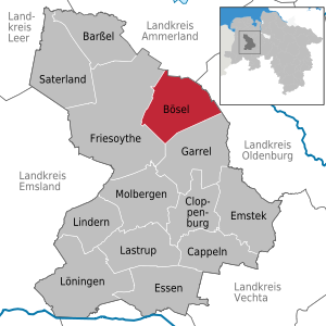
| Location of the municipality of Bösel in the district of Cloppenburg | ||
  |
||

Bösel is a unified municipality in the district of Cloppenburg in Lower Saxony ( Germany ).
geography
Location and geology
The north-eastern part of the municipality of Bösel lies in the high moor of the Vehnemoor . The south-western part of Bösel is one of the undulating elevations of the Friesoyther Geest (center of Bösel: 16 m above sea level , Osterloh: 26 m above sea level) and the Garrel valley sand plates. The border between Geest and Moor corresponds roughly to the course of the Lahe .
Neighboring communities
Neighboring communities are in the north the community Edewecht ( district Ammerland ), in the east the community Wardenburg ( district Oldenburg ), in the south the community Garrel and in the west the city Friesoythe (both district Cloppenburg).
Community structure
Bösel has nine districts: Bösel-Ort, Edewechterdamm (only a few houses, most of them belong to Friesoythe), Glaßdorf , Hülsberg , Osterloh, Ostland , Overlahe , Westerloh and Petersdorf , which is Bösel's largest farming community.
climate
The climate in Bösel is strongly Atlantic due to its proximity to the North Sea, with moderately warm summers and relatively mild winters. Climate data from the closest measuring station of the German weather service in Friesoythe-Altenoythe (N 53 ° 04 '; O 07 ° 54') indicate a long-term temperature mean of 9.6 ° C and an average rainfall of 784 mm / year for the reference period 1981-2010. In general, summer and autumn are more humid, while winter and spring are somewhat drier (maximum June: 78 mm; minimum April: 45 mm).
history
Origin of the place name
Earlier versions of the place name are: approx. 1080/88 Borsla , 1320 Borsele [Or], 1424/50 to Bosele [Or], Boesell (1535). The historians' dispute as to whether the name "Borsla" meant Barßel or Bösel has now been settled in favor of Bösel. In a document from 1407 from the Daren manor archive, Johann, nobleman of Diepholz, testifies " dat wij in vortijden hebt enlivened Otten Sloren ... (namely the ) luttiken tegheden to Borzell in the kerkspele to Qyte" . The Diepholzian rights to the Böseler tithe documented here can be seen as an indication that the Borsla tithe mentioned in 1080/88, which the Osnabrück bishop Benno II handed over to an ancestor of the Diepholz noble lordship, actually means the Böseler tithe, says Peter Sieve, archivist at the Vechta Office. Evidence is provided that the Borsla mentioned in 1080/88 really means Bösel and not Barßel. The etymology of the place name is unclear, because the ending -la, weakened -le, both on the Gw. / -Loh (e) and on the suffix -l- as an element of a place reference. can go back. As a basis, think of germ. * Burs- from idg. * Bhrs- "upstanding, tip, bristle", which in Swedish borre, engl. bur "burdock" has been preserved. The location of Bösel on the approx. 15 m high Geest ridge in the middle of the moor landscape on the Lahe supports the interpretation as "elevated forest".
From the early days to the end of the 19th century
Settlement finds show that people lived in the municipality as early as the Middle Stone Age . The first settlement was probably a clustered village on the higher Geestrücken , which could also be used as a field without drainage. The place Bösel was first mentioned in 1080 as Borsla (= "forest on a wavy hill") in a document of the Bishop of Osnabrück . In 1473 Bösel had 25 families and six families in neighboring Osterloh. A chapel presumably existed in Bösel before 1500 , but it was not mentioned in writing until 1613 (renovation in 1798, 1833/35: new building as St. Cäcilia Church, 1922 extension as a neo-baroque cruciform church) . Boesel and Osterloh belonged to the parish Altenoythe , the then capital of the settlement area, but the 19th century managed until the beginning of the cooperative peasantry largely self. 1803 ended with the Reichsdeputationshauptschluss the over 400-year-old spiritual rule of the pin Munster , his office Cloppenburg went to Grand Duchy of Oldenburg over. According to its municipality code of 1831, the parish Altenoythe formed a self-governing political municipality together with Bösel . On March 2, 1876, Bösel became an independent municipality against the resistance of Altenoythe . Bösel's ecclesiastical independence as early as 1874 also contributed significantly to this.
Economic development of Bösel until the end of the 19th century
The main livelihood was the low-yield agriculture, whereby until the beginning of the 20th century the nutrient-poor geest soils could only be wrested by laborious pest fertilization and the bog soils by bog fire culture . Livestock farming was mainly limited to undemanding Heidschnucken (1892: 5949 sheep). The processing of their wool into garments was the most important part-time occupation for large parts of the population. In 1869/70, high population pressure and declining opportunities to earn additional income due to the summer hollidays led to the expulsion of 47 colonists in today's Petersdorf. It was not until the 20th century that the use of harnessed machines and the growing acceptance of mineral fertilizers brought about an enormous upswing in agriculture. The Friesoythe-Cloppenburg branch line, opened in 1906, and the construction of the first paved roads, which significantly improved transport connections and greatly simplified the transport of bulk goods such as fertilizer , also contributed to the spread of artificial fertilizers . In 1924 electricity arrived in Bösel.
Settlement development and colonization
- Petersdorf
- As the first controlled settlement activity in the area of today's municipality, Petersdorf was established in 1874 through brand division and settlement and cultivation of wasteland ( Oldenburg internal colonization ). The first settlers, who were interned as early as 1869/70, lived poorly in earth huts built from Plaggen. This early settlement activity turned out to be economically largely unprofitable. Therefore, the name of the place after Grand Duke Nikolaus Friedrich Peter von Oldenburg did not take place until 1876, as many buildings had not yet been completed by the requested date or had already been partially abandoned. It was not until 1877 that all settlers had a permanent home. The introduction of the newly emerging artificial fertilizer , which also made intensive livestock farming possible, was decisive for improving economic conditions . In the 1920s, road construction in the direction of Wardenburg eliminated the previously disadvantageous peripheral location of Petersdorf. After the Second World War, the population of Petersdorf doubled due to the influx of war refugees, but has stagnated since then. After the experiences with the early Petersdorf colony, further settlement expansion in Bösel stalled for a long time.
- Glassdorf
- It was not until the economic pressures and pressure from settlers as a result of the First and Second World War that settlement activity in the municipality revived in the 20th century - above all through colonization of the vast areas of the Vehnemoor . The first to be established in 1923 in the municipality of Bösel was the Glaßdorf colony of the state of Oldenburg . The settlement office set up 30 settlement sites on 365 hectares. The name of the settlement was given by the state economist Robert Glaß (1867–1944).
- Ostland
- In this context, the Ostland settlement was established in the municipality of Bösel in 1927 and the settlements Habern I. and Harbern II. (Municipality of Wardenburg ) and Hogenset (municipality of Edewecht ) in the immediate vicinity . The colonate sizes were around 9–12 ha. In preparation for the settlement, the moor was cooled by hand. H. Sand from the bog subsoil was brought onto the raised bog or already peated areas. Since the emergency measures of the Weimar Republic to create employment were concerned, profitability played a subordinate role.
- Hülsberg
- After the Second World War and the large number of applicants for settlement (refugees), the Hülsberg settlement was created. At the time, however, the lower settlement authorities in Oldenburg did not have any peat land available for settlement. Therefore, on Korsorsstraße in Vehnemoor, a state-owned, 5 m thick and 350 hectare high moor area was cultivated directly through drainage with border ditches and pipe drainage ( "German high moor culture " ). While the original planning provided for a row settlement, later a closed settlement complex of 22 full-time businesses with around 15 hectares each emerged. As the last settlement in Germany based on raised bog culture, Hülsberg, with its favorable internal traffic situation, represents the top form of this type of settlement.
- Overlahe
- Overlahe was established between 1956 and 1961 as the fifth and youngest settlement establishment in the municipality of Bösel . On the basis of the Settlement Promotion Act (1953) and the Federal Expellees Act (1961), farmers displaced from their homes were set up in Overlahe on a 317 ha large, industrially peeled area of the Vehnemoor Society. In preparation for agricultural use, the peated bog was sanded over and then mixed ( "sand-bog mixed culture" ). The Ottomeyer plow constructed after the war and the Rathjens sanding machine ("vole machine") contributed significantly to cultivation . The soils obtained in this way can produce excellent yields. The designated 18 sites each had 15-17 hectares. The farms are parallel to the 3.8 km long Overlaher Straße, which runs in north-south direction. A village center with houses, school, church and sports field was planned, but was no longer realized. The name "Overlahe" refers to old land maps in which the land north of the Lahe was referred to as "Over the Lahe" ("Över de Lahe"; Lahe: wetland).
Bösel under National Socialism (1933–1945)
In 1933 the municipality of Bösel was merged again with Altenoythe due to a lack of economic efficiency and the low population of 1649 people, and the administrative headquarters were relocated there.
In 1936, Bösel was connected to the so-called " Kreuzkampf " during the Nazi era . Today we know from extensive scientific studies that the events in Bösel - the Sunday inauguration of the new school in Bösel by Pastor Franz Sommer after the state inauguration on Saturday - was not the "pivot" of the dispute. The "Cross Decree" of November 4, 1936, with which the Minister for Churches and Schools, Julius Pauly, wanted to ban the crosses and Luther pictures from schools, was only the culmination of the "conformity" by the Nazi regime was started as early as 1933 and had the purpose of enforcing their power politics against the confessional. The Bösel school inauguration was therefore an occasion, not a cause. Rather, it was the climax and the highest degree of conflict between the National Socialist universal claim to power and the Church's influence in certain areas of society. During this time the struggle of the National Socialists against the Church became more and more open. And: The cross fight also had its roots in the National Socialist school policy based on its anti-Christian ideology. What followed was one of the few public disputes against measures by the National Socialist government. This led to massive protests by the population in the predominantly Catholic Oldenburger Münsterland. Most recently, the Oldenburg Gauleiter Carl Röver was forced to at least partially withdraw the decree and continue to allow crosses in classrooms. For a long time, the brown rulers did not dare to take action against these protests and the sermons of the Catholic clergy. Arrests and repression did not begin until a year later. As a result, the “German School” continued to play an important role in the Nazi regime's intended penetration of all areas of life and the political socialization and ideologization of young people, also in Bösel. The cross-fight and the Luther image could not stop that.
In the last days of the Second World War , Bösel was also affected by fighting. At the beginning of April 1945, retreating German associations stopped in the municipality. As the front approached, civilians were increasingly threatened by Allied low-flying aircraft. On April 15, the first tank of the 4th Canadian Armored Division reached Bösel. The Canadian main thrust from the direction of Thüle surprised the German defenders, who expected an attack from the direction of Friesoythe and then had to hurry away. On April 16, the German troops retreating into the moors came under heavy fire, which also endangered the many civilians who had fled there. In this situation, a three-hour break in the fighting made it possible to evacuate the civilians.
Since November 2015, two steles on the war memorial have been reminding of a dark chapter in local history during the Nazi era. They stand for Stanislav Dytwach and Alfred Horsey. Dytwach (born 1931) was abducted as a forced laborer from Zimotki, Poland. He was working on a farm when he fell victim to the Poland decrees . He fathered a child with a German woman, was arrested in March 1942 by the Wilhelmshaven Gestapo and eight months later in the presence and absence of a trial. a. of the then Bösel mayor, the local group leader of the NSDAP and the Cloppenburg governor hanged in the Böseler Kronsberg. The bad guys were asked to attend the execution. Many accepted the "invitation". In addition, there were the forced laborers in the area who had to be present to “deter” the situation. The 22-year-old English pilot Harry Alfred Horsey flew over Bösel in his Hawker Tempest just a few days before the end of the war and had to make an emergency landing due to an engine failure. After his arrest, two soldiers were supposed to transfer him to the Varrelbusch airfield . On the way there, one of the soldiers shot him from behind. The murderer was sentenced to life imprisonment by an English military tribunal after the war.
Bösel after 1945
The early post-war period was marked by the rebuilding of democratic structures , the repair of the place and destroyed bridges over the Aue and Lahe as well as the lack of almost all everyday objects. On the other hand, there was no shortage of heating material that could be dug up as black peat. Hundreds of refugees and displaced persons came from the broken home and went to a broken part of the country. Extreme living conditions also in Bösel with accommodation in camps, lice, bugs, fleas, forced admissions to “apartments”, which were often stables. There is no doubt that many of the local population treated the refugees and displaced persons after the war more distantly and repulsively than hospitably. And then they were also Protestant ... In 1948, the problems surrounding the humane accommodation of refugees escalated in Bösel, and objections to allocations and the confiscation of living space increased. The council pulled the emergency brake and decided that the community should build refugee homes. Buying and remodeling houses by the community turned out to be a good solution. In addition, more and more land was offered and self-built. On April 1, 1948, the old community of Altenoythe, which had existed since 1935, was dissolved and Bösel became independent again.
Economic development of Bösel in the 20th century
Strong impulses came from the Oldenburg settlement office in the first half of the 20th century, which enabled targeted settlement and cultivation of the moorland through massive land purchases, drainage measures and improved amelioration techniques (deep plowing, etc.) (see below). In just six decades, the agricultural structure changed decisively: while around 1910 only 1000 of the approximately 10,000 hectares in the municipality were used for agriculture and 9,000 hectares of wasteland or moors, by 1970 the agricultural area had increased fivefold to around 5,500 hectares. In the place of extensive buckwheat cultivation, more demanding cereal crops emerged, sheep farming was replaced by refining cattle (1892: 823, 1912: 1205, 1948: 2219) and pigs (435, 1276; 1209). Since the 1950s, the mechanization of agriculture has increased productivity and reduced the need for labor. This brought about an economic structural change in the commune, which had previously been dominated by agriculture. Increasingly - also as a result of the " economic miracle " - service or industrial companies that profited from the economic upturn and offered jobs for former agricultural workers. Increasing individual traffic led to the abandonment of passenger transport on the railway line in 1968, and land consolidation began in Bösel in 1969. A quarter of a century later, in 1994, it was completed. During the restructuring process, mostly smaller, scattered areas, i.e. fragmented real estate, are combined into larger and therefore more effective usable areas. This also includes the creation of appropriate paths, roads and bodies of water as well as similar public facilities. From the beginning, conflicts in the relationship between agriculture and nature conservation were inevitable. In addition to the “cleaning up of the corridors”, the town of Bösel owes this company, among other things, the bypassing. And Bösels Mitte owes a jewel to the land consolidation: the village park, which later gave Bösel an award as a “Green Village” and was completely redesigned in 2018/19. In the middle of it the pond, which also serves as flood protection.
Religions
In Bösel, the majority of 4919 inhabitants (57.7%) belong to the Roman Catholic denomination . A further 1,462 inhabitants (17.2%) are Evangelical Lutheran and 2,143 inhabitants (25.1%) belong to other denominations or are non-denominational (as of the end of 2019).
politics
Municipal council
The council of the community of Bösel consists of 20 council women and councilors. This is the specified number for a municipality with a population between 7,001 and 8,000. The 20 council members are elected by local elections for five years each. The current term of office began on November 1, 2016 and ends on October 31, 2021.
The full-time mayor is also entitled to vote in the municipal council.
The last local election on September 11, 2016 resulted in the following:
| Political party | 11th September 2016 | September 11, 2011 | September 10, 2006 | ||||||
| CDU | 63.13% | 6,445 | 13 seats | 68.52% | 6.218 | 14 seats | 73.3% | 6,512 | 15 seats |
| SPD | 31.69% | 3,236 | 6 seats | 25.07% | 2,275 | 5 seats | 15.4% | 1,370 | 3 seats |
| FDP | 5.17% | 528 | 1 seat | 6.40% | 581 | 1 seat | 11.3% | 1.006 | 2 seats |
| voter turnout | 56.71% | 52.99% | 47.67% | ||||||
mayor
Hermann Block ( CDU ) has been the full-time mayor of Bösel since 2006 . In the last mayoral election on February 16, 2014, he was re-elected with 71.47% of the vote.
coat of arms
The coat of arms (since 1969) of the municipality of Bösel shows (blazon) under a golden shield head, therein three (drawn in perspective) red bricks 2: 1, in red two crossed golden peat spades.
With the coat of arms, the municipality sets a monument to its brickworks and the huge moorland that played such a crucial role in the history of the village. The three perspective bricks in the upper part of the coat of arms are reminiscent of two brick factories , one of which (von Kobrinck, later Meierkord) can be traced back to the 15th century. The history of the second brickworks, Krusemeier, has not yet been processed. The crossed peat spades in the lower part of the coat of arms indicate that a third of the municipal area used to be bog . The spades were used to dig white and black peat . The colors red and gold indicate the old Munster and Old Oldenburg colors. Bösel belonged to the Niederstift Münster. The peculiarity of the Niederstift was that politically it belonged to the Hochstift Münster, but ecclesiastically to the Diocese of Osnabrück until 1666. The Niederstift included today's Oldenburger Münsterland, to which Bösel also belongs. The prince-bishop's coat of arms in gold-red-gold, whose bearers were Konrad von Berg in 1309 and Ludwig von Hessen in 1310, is proven as the coat of arms of the Münster monastery as early as 1300. The existence of the prince-bishopric ended on February 25, 1803 with the Reichsdeputationshauptschluss, through which the princes who had lost property to the French Empire as a result of the Peace Treaty of Luneville on the left of the Rhine were compensated primarily with spiritual areas. The Niederstift Munster, among other things, with the offices of Cloppenburg and Vechta fell to the Duchy of Oldenburg , namely to the Protestant Duke of Oldenburg. Their population has remained predominantly Catholic to this day. The bishop of Munster remained the spiritual head. Since the 1820s, the episcopal official in Vechta has been his permanent representative for the entire area of the Oldenburger Land, which according to ecclesiastical law still belongs entirely to the diocese of Münster. To secure the continental blockade (an economic blockade against England), Napoleon had north-west Germany, and thus also today's Oldenburger Münsterland, declared French national territory in 1810. After the Battle of the Nations near Leipzig in 1813, the French fled the country and Prussia took over provisional administration. Until 1946, the Oldenburger Münsterland remained part of the Grand Duchy of Oldenburg or (since 1919) of the Oldenburger Land. It has belonged to the state of Lower Saxony since 1946. As you can see, Bösel was right here with the gold-red color scheme, because two red crossbars in gold also led the coat of arms to Oldenburg.
Community partnerships
Since September 8, 1990 there has been a partnership with the town of Dippoldiswalde (colloquially Dipps ) in the Saxon Switzerland-Eastern Ore Mountains district in Saxony .
Culture
Churches
Catholic Church “St. Cecilia "

The Catholic Church of St. Cäcilia Bösel appears in the record book of the Cloppenburg Office in 1574 under the name “St. Martin ”as a neighbor of the Bösel farmer Gerd Kühter. This is the first reference to a chapel in Bösel which belonged to the church in Altenoythe and was dedicated to St. Bishop Martin was consecrated. It was probably built before the Reformation. A note from 1630 also mentions a chapel on the border of the Oldenoyte parish, named Bösel, but in a way that suggests that this chapel was no longer of recent origin. "There is a small bell in a structure on the roof," Pastor Hanschen reported on September 9, 1669 to Prince-Bishop Christoph Bernhard von Galen. In 1724 it says: “The chapel in Bösel is new, but not a fitting place of worship, it is not assigned.” In 1798 and 1799 the chapel was completely rebuilt and expanded. "This building lasted until the early 1830s, when it was torn down to make way for a new place of worship". The new, larger chapel was completed in 1839 and consecrated on July 14, 1839. The Grand Duchess Cäcilie zu Oldenburg, b. Princess of Sweden, laid the foundation stone. For this the patronage was changed from Martin to Cäcilia. The husband, Grand Duke Paul Friedrich August gave the altarpiece "Christ with the Cross". In 1922/23, Pastor Franz Sommer realized the plans to add the transept, choir, side chapel, pieta and sacristy to a cruciform church in the neo-baroque style. On May 16, 1923, the enlarged church was consecrated by the Bishop of Münster, Johannes Poggenburg (1913–1933). The wall paintings are by Gerhard Lamers (Kleve) and the high altar, donated by the Heyens family, Bösel-Osterloh, is by the art sculptor Fritz Ewertz, Münster.
During the Second World War, the bells of St. Cäcilia had to be given up. The roof and windows of the church building were destroyed in a street blast in 1945. After a bronze arial and money collection in the community, on February 2, 1949 in the bell foundry in Gescher / Westf. new bells are cast. They were given the names again: Maria, Cäcilia and Martinus. After the bells were solemnly consecrated by Pastor Franz Sommer on March 27, 1949, all bells were rung for the first time on April 4, 1949. In 1959/1960 the nave was demolished and extended by about 4.5 m on both sides. All pictures of the church were whitewashed. The recommendation, if not an order, came from Münster, namely from the diocesan curator responsible for art monuments and art issues. Why? It was the much-invoked spirit of the time that sparked that “iconoclasm”. If one investigates this mind, one finds that it has a strong social and mass psychological component. We Europeans and, above all, we Germans no longer wanted to tie in with a story that had saddled the continent and its people with endless destruction, endless suffering and endless guilt. The new beginning should be radical and thorough. So get rid of "historicism" to which a Lamers was also obliged. "Purification" was then called the whitewashing of Lamers' paintings in some places. In the 80s the parish paid a lot of money to expose and restore the whitewashed ornamental and figural wall paintings.
With effect from October 30, 2005, the St. Peter and Paul chapel in Petersdorf and the St. Cäcilia parish in Bösel were merged to form the St. Cäcilia Catholic parish in Bösel. The “Rubens” by Bösel: The unsigned altarpiece “Christ with the Cross”, donated by Grand Duke Paul Friedrich August in 1839, turned out to be a painting from the workshop of the most famous Baroque painter, Peter Paul Rubens (1577-1640). On the occasion of the return of the masterpiece, this was confirmed by the art historian and expert on Dutch painting of the 16th and 17th centuries, Dr. Ursula Härtling (Hamm) and the restorer Marita Schlüter (Everswinkel). The restorer believes that Rubens himself might have worked on the Bösel painting: the technical structure and the brushwork correspond to the typical work method in his workshop and the same "final corrections to the paint layer as attributed to Rubens himself" can be found. The painting shows the risen "Christ with the cross" as "Salvator mundi" (savior of the world) in half length. It unites the belief in the cross of its time with the counter-Reformation spirit in a powerful way. When the chapel was rebuilt in 1836, the “most submissive servants and servants” from Bösel and Osterloh turned to the “most illustrious Grand Duke Paul Friedrich August” with a request for an altarpiece. The "archangelical" sovereign ruled with "paternal grace and grace" a grip on his fund. For 139 years one of many “Rubens” hung in Bösel, and no one suspected of its importance.
Catholic Church “St. Peter and Paul "
The Catholic Church “St. Peter and Paul ”in Petersdorf, Bösel's largest peasantry, was consecrated on May 18, 1950 (Ascension Day) by the Friesoyther dean, cathedral capitular Bernhard Küstermeyer. A month earlier, chaplain Joseph Käter had been appointed first pastor in Petersdorf. The population greeted him with enthusiasm, because a great wish had come true. The Petersdorfers wanted their own church much earlier. The population grew rapidly and the road to Bösel was long. The people got the stones for it after the First World War. The community of Bösel made a forest plot available. The Petersdorfers laid the trees flat with axes and "dawashing". The church not only blended in harmoniously with its surroundings, it gave the place a language with clear and strong expression. Further collections and the “Peterpfennig” in the village later enabled the interior decoration. Just a year later, the church square and the new cemetery were also prepared. In 1952 the altar, pulpit, communion benches and a baptismal font completed the church ambience. In the same year, Auxiliary Bishop Heinrich Roleff donated his confirmation for the first time in Petersdorf.
Käter was replaced by chaplain Clemens Haskamp in 1957. Kaplan Franz Sommer came, a nephew of the former (and eponymous) Bösel pastor. His activity in the village lasted from 1961 to 1964. In 1964 August Thoben from Garrel became the new pastor. In 1969 he left Petersdorf and Hubert Gnida followed on April 1, 1969. In 1971 he went to Cloppenburg as vicar. From November 1, 1971 to October 31, 1987, he was followed by Father Willibrord Thoben, a native of the Netherlands. In 1976 there was a new church tower and new bells in it. After Father Willibrord Thoben left in 1987, the rectory was empty. A clergyman for Petersdorf was no longer available. The building was initially rented out and later sold. The chapel congregation remained independent with its own bodies such as provisional, parish council and church committee, but from November 1987 it was placed under the administration of Pastor Karnbrock from Bösel. Nothing changed in this form of organization when Pastor Karnbrock left the service in 1990 and Pastor Paul Horst became the new pastor in Bösel. As a parish administrator, he was also responsible for looking after the chapel community of St. Peter and Paul in Petersdorf. Father Heinrich Jankowski, born in Visbek, worked from 1992 to 2003 as a cooperator in Petersdorf. He was a Redemptorist. From 1972 the parish rectorate became a parish, and from October 30, 2005, "Peter and Paul" formed a new parish with St. Cäcilia Bösel.
Evangelical Resurrection Church
The Evangelical Church of the Resurrection was built in 1960. ZIt was planned by the Westersted architect Hobbie. At that time only about 500 Protestants lived in the village. Before the Second World War there were only four Protestant families in Bösel. The first believers used to visit the church in Friesoythe, which had had a church since 1912 as the chapel parish of Edewecht and had been a parish for Bösel and Scharrel since 1935. After the Second World War, a stream of refugees and displaced persons came to Bösel and the number of evangelical believers grew to around 1,000. The services took place first in the school and then until 1960 in the hall of the summer restaurant. But they are also said to have been held in Moorgut Kartzfehn. For the new church to be built in 1960, the community provided a plot of land on Eschstrasse. The church and the bell tower were built with a lot of work by the believers. It was planned by the Westersted architect Hobbie. The Resurrection Church in Bösel was consecrated on the 4th Advent in 1960 by Bishop D. Jakobi. The first pastor was Georg Beidenhauser in 1961, who came to Bösel with his wife Marie-Louise for 31 years and played a decisive role in shaping life in the parish. Among other things, he founded a wind group, because there was no organ at the time.
In 1985, when the parish celebrated its silver jubilee, the extended parish hall was opened for its intended purpose, intended for Bible studies, but also for women and youth groups and the trumpet choir. Oberkirchenrat Heinrich Höpken preached the sermon during the festival service. When Beidenhauser, who was born in Westphalia, retired in 1992, Pastor Angelika Menz replaced him after a while. After a long vacancy, Ralph Hennings became the new pastor of the Evangelical Church in 1996. In 1997 he was elected pastor. He was later replaced by Pastor Meike von Kajdacsy. In 2013 the Church of the Resurrection was completely renovated. The artist Uwe Appold from Wilhelmshaven designed five Christ windows for the Evangelical Lutheran Church of the Resurrection in Bösel. These designs are the result of the artist's encounter with the monumental mural by the church painter Hermann Oetken (1909-1998), which dominates the church in Bösel. Uwe Appold deals critically and creatively with this given work of art. The result is five windows that represent the importance of Jesus Christ for our life and our faith in a unique way. In the summer of 2003 the windows were installed in the church. They were financed solely from donations.
music
With the mixed choir, the big band Bösel and the Lower Saxony Sound Orchestra (NSO), the municipality of Bösel has three musical groups that are known far beyond the borders. Cultural highlights are the annual Advent concert of the mixed choir on the 1st of Advent and its “summer serenade” and, since 1961, the Euro Music Days. The Euro Music Days take place at the beginning of September and are organized by EURO Bösel e. V. organized. Both instrumental formations give several gala concerts every year. There is also a church choir and the singing and playing group in the Petersdorf district.
Museums and parks

In the immediate vicinity of the village center is the village park, which borders on an area where folk, music and sports festivals regularly take place. The village park owes its existence to land consolidation, which also serves to protect against floods. There is also the “Pallert” museum park, where you can find out more about the predominantly agricultural history of the community. On the site there is the "Heimathaus", an agricultural machinery museum, a bread bakery and a farm garden. "Pallert" means nothing more than "swampy, low, damp land". The name should refer to an "emergency well" from which water is fetched was used in fires. The location was not next to the current home, which today bears the name "Pallert", but roughly where the torture column stands today.
Sports
Different types of sport are practiced in the municipality of Bösel; football, cycling, swimming, volleyball, boules, jazz dance, sport shooting, fishing, bowling, folk dancing, table tennis, horse riding and tennis, to lesser known sports such as Jakkolo or summer biathlon by the Bürgererschützenverein, which has already had two German champions in this sport. The largest sports clubs are the sports club Bösel (soccer), the sports club Petersdorf, the tennis club Bösel, the shooting society St. Franziskus Petersdorf, the DJK Bösel and the citizens shooting club.
Regular events
- Böseler Schützenfest (third weekend in July)
- Petersdorfer Schützenfest (second weekend in July)
- Euro Music Days (beginning of September)
- Awarded the Borsla Prize of the Borsla Association for Low German Language and Literature e. V. in November every year
- Christmas market (December)
- Advent concert of the mixed choir on the first Advent
- Performances by the DJK-Theatergruppe e. V. (January)
- Holiday pass campaign of the community youth association (in the summer holidays)
- Beer festival of the Lower Saxony Sound Orchestra in the village park (end of May)
- St.Martin charity dinner (2nd Tuesday in November) with a fundraising campaign for Bösel associations that provide humanitarian aid
Economy and Infrastructure
As a member of the “Zweckverband Intercommunal Industrial Park Coastal Canal”, Bösel is involved in the c-Port industrial and commercial area .
education
Schools:
- St. Martin Elementary School
- High school
- Petersdorf Elementary School
literature
- Municipality of Bösel (ed.): Municipality of Bösel
- Vol. 1: Municipality of Bösel 1876–1976 . With contributions by F. Schwalm, F. Haskamp, J. Meyer, B. Robke, H. Werner, J. Stukenborg, C. Themann, A. Schröder, J. Ferneding, B. Grafe, H. Lenzschau. Bösel 1976.
- Vol. 2: Municipality of Bösel 1976-2001 . Bösel 2001.
- Benno Grafe (Red.): Christian monuments in the community of Bösel . Photos by Franz Schwalm. Heimatverein Bösel. Bösel 2002.
Web links
Individual evidence
- ↑ State Office for Statistics Lower Saxony, LSN-Online regional database, Table 12411: Update of the population, as of December 31, 2019 ( help ).
- ^ Homepage DWD Friesoythe-Altenoythe
- ^ Jürgen Udolph (research): The "place name researcher". (No longer available online.) In: Internet site NDR 1 Lower Saxony . Archived from the original on December 28, 2014 ; accessed on August 3, 2019 .
- ↑ Homepage Petersdorf
- ↑ Oldenburg and the northwest. Westf. Geogr. Studies 25. (Ed .: Inst. F. Geogr. Länderkd. Univ. Münster). Munster i. W. 1971. p. 304.
- ^ Inscription on the stele for Stanislav Dytwach: "In memory of Stanislav Dytwach (1.1.1913 - 14.11.1942) murdered on November 14th, 1942 as a slave laborer during the Nazi tyranny in Bösel"; Inscription on the stele for Harry Alfred Horsey: “In memory of Harry Alfred Horsey, 22-year-old pilot in the Royal Air Force, murdered on April 3rd, 1945 during the Nazi tyranny in Bösel”.
- ↑ Bösel: Our community - Bösel residents in numbers , accessed on January 11, 2020.
- ^ Lower Saxony Municipal Constitutional Law (NKomVG); Section 46 - Number of Deputies. In: Internet site for the Lower Saxony Regulation Information System (NI-VORIS). December 17, 2010, accessed August 23, 2019 .
- ↑ Overall results of the 2016 municipal elections on September 11 , 2016 , accessed on January 25, 2017
- ^ Bösel municipality - result of the mayoral election. February 16, 2014, accessed September 25, 2014.
- ↑ Main statute of the municipality of Bösel. ( Memento from December 18, 2015 in the Internet Archive ) In: www.boeselonline.de. December 19, 2011, accessed August 23, 2019.
- ^ Lower Saxony Sound Orchestra (NSO). In: www.nso-online.de. Retrieved August 23, 2019.
- ↑ Otto Höffmann: "On Bösel once Trullala" ... history and stories of the Bösel musicians festival . Musikverein Bösel, Bösel 1986.
- ↑ a b Euro Music Days Bösel. In: www.euro-boesel.de. Retrieved August 23, 2019.
Barßel | Evil | Cappeln (Oldenburg) | Cloppenburg | Emstek | Essen / Oldenburg | Friesoythe | Garrel | Lastrup | Lindern (Oldenburg) | Loeningen | Molbergen | Saterland