Isla de los Estados
| Isla de los Estados | ||
|---|---|---|
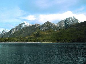
| Puerto Cook on the north coast | ||
| Waters | Atlantic Ocean | |
| Archipelago | fire land | |
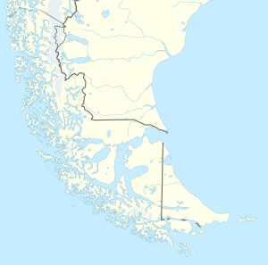
| Geographical location | 54 ° 49 ′ S , 64 ° 17 ′ W | |
|
|
||
| length | 63 km | |
| width | 15 km | |
| surface | 530 km² | |
| Highest elevation | Montes Bove 823 m |
|
| Residents | 5 military <1 inhabitant / km² |
|
| main place | Comandante Luis Piedra Buena (Puerto Parry) | |
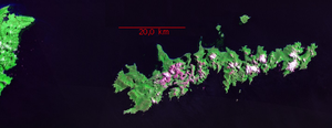
| Satellite image (Landsat Geocover) with Tierra del Fuego to the west | ||
Isla de los Estados (German State Island ) is an uninhabited island in the extreme southeast of Argentina ( Tierra del Fuego ). It is located 30 km east of the main island of Tierra del Fuego and is administratively part of the city and district of Ushuaia in the Argentine province of Tierra del Fuego .
geography
The island has an extension of about 530 km², it is 63 km long and up to 15 km wide. It is separated from the main island of Tierra del Fuego in the west by the Le Maire Strait (Spanish Estrecho de Le Maire ). Cape San Juan forms the easternmost point of the island . The lesser known westernmost point is Punta Cuchillo . The southern point of Cabo San Bartolomé on the López Peninsula is also very far to the west of the island. The nearby (five kilometers east) Islotes 350 Pies extend slightly further south. The northernmost point is Cabo Colnett . However, further north are the Isla Año Nuevo and the Isla Observatorio as well as other smaller islands. Almost all of the island's terrain is mountainous and is home to several glacial valleys and lakes.
history
San Juan del Salvamento lighthouse in the east (1898)
Maritime historians assume that Francisco de Hoces made the Isla de los Estados as early as 1526, but this is only confirmed when it was discovered by the Antwerp Jakob Le Maire in 1616. Le Maire Street, a strait , is named after him. It separates the island from Tierra del Fuego . The name of the island comes from the Dutch state Eylandt , after the Staten Generaal , the parliament of the then Republic of the Seven United Netherlands . When the route around America's southern tip was the only sea route from the Pacific to the Atlantic or vice versa, a number of ships chose the shorter route through the Le Maire Strait despite the cross currents that were critical for sailors, while others took the further east around the State Island.
In 1978 a small military base named Comandante Luís Piedra Buena was built at Puerto Parry . Puerto Parry is a narrow and long fjord that cuts into the island from Bahía San Antonio in the north and is lined with 600 meter high rock walls. The base's four to five soldiers make up the island's only population.
In 1991 the island was declared a nature reserve.
population
There are no regular settlements, only a scientific station and a base for the Argentine armed forces . Tourist activities are rare and expensive because of the difficult access.
reception
The island is the setting of the adventure novel The Lighthouse at the End of the World by Jules Verne .
literature
- Juan Federico Ponce & Marilén Fernández: Climatic and Environmental History of Isla de los Estados, Argentina. Springer, 2014. ISBN 978-94-007-4362-5 (print); ISBN 978-94-007-4363-2 (eBook)


