
New East Prussia


New East Prussia ( Prusy Nowowschodnie in Polish ) was a province of the Kingdom of Prussia from 1795 to 1807 . The province was created after the Third Partition of Poland (1795). The previously Polish area around Warsaw south of the Vistula and the Bug became part of the province of South Prussia as part of the division . The south Prussian districts to the north (right) of the Vistula became part of New East Prussia. New East Prussia roughly encompassed the historical Podlaskie and Mazovia voivodeships between East Prussia and the Memel and Bug rivers . In 1806, about 900,000 people lived in New East Prussia in an area of almost 55,000 km².
Emergence
As early as 1793, Prussia and Russia had agreed on the second partition of Poland , whereupon Prussia's relationship with Russia and Austria deteriorated. Austria could not record any land gain. The Prussian King Friedrich Wilhelm II († 1797) got into armed conflict with rebellious Poles who were striving for independence in 1794 as a result of the Kościuszko uprising . The Prussian army under the king himself captured Krakow, but besieged Warsaw in vain. Only Russia managed to put down the uprising. The decision on the final partition of Poland fell to the Russians. In the Petersburg Treaty of January 3, 1795, Russia and Austria reached an understanding on the final partition of Poland. On October 24, 1795 , Prussia also joined the partition treaty.
geography
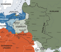
Prussia received from the former Poland-Lithuania the land north of the Bugs and southwest of the Memel, parts of North Mazovia with Warsaw, Ciechanów and Pultusk , parts of Podlachia with Białystok and parts of Lithuania south of the Memel. This corresponds to the previous Masovian , Podlachian and Troki (Lithuanian Trakai ) voivodships .
The city of Warsaw was added to Prussia, as neither Russia nor Austria wanted to rule the rebellious city. Contrary to what is often shown, it became part of the province of South Prussia, as the Vistula and the Bug formed the southern border of New East Prussia.
Outwardly, New East Prussia lay southeast of East Prussia and east of South Prussia , which Prussia had already been added to by the Second Partition of Poland. South of New East Prussia was the Austrian West Galicia , which Austria had also received through the Third Partition of Poland. To the east lay the now Russian Polesia (not to be confused with Podlachia ) and to the northeast lay the now Russian Lithuania .
Through the Third Polish division of Prussia also received a small addition to East Prussia New Silesia , part of the Province of Krakow between Silesia, South Prussia and West Galicia (see also Republic of Krakow ). After the third division of Poland, Poland disappeared from the political map for 123 years and only became independent again in 1918.
Surname
Prussia has only called the “new acquisition” since November 20, 1796 by cabinet resolution as “New East Prussia”, a designation that had previously been introduced by the Bialystocker Chamber Commission for the area administered by it. Originally, the newly acquired area was to be divided between the neighboring departments. Due to the backward conditions in the acquired areas, the plan, which was also made for reasons of savings, was not implemented.
population
With the two provinces, Prussia received 20% of the Polish national territory and 23% of the Polish population. As a result of Friedrich Wilhelm's acquisition of the Second and Third Partition of Poland, there were almost 2.5 million Poles for every 6 million Germans, which meant that Prussia was weakened internally.
In addition, the proportion of the Jewish population in the Prussian monarchy increased by eighty percent.
The End
Relations between Prussia and Austria suffered a rupture due to Prussia's great territorial gains. The unsteady neutrality policy of the new Prussian King Friedrich Wilhelm III , who has ruled since 1797 . additionally isolated the country. In 1806 Prussia faced Napoleon almost alone in the Fourth Coalition of the coalition wars , and after the battle of Jena and Auerstedt in the Peace of Tilsit in 1807 , Prussia lost all areas on the left Elbe and most of the land gained from the Polish partitions.
In the Peace of Tilsit New East Prussia, Napoleon struck the newly created buffer state to Russia and Napoleonic satellite state, the Duchy of Warsaw (in personal union with the Kingdom of Saxony). The Białystok District was added to the Russian Empire . New East Prussia disappeared from the political map again after its short twelve-year history. After the Congress of Vienna in 1815, the area of the former New East Prussia was added to the newly created Congress Poland (personal union with Russia).

Prussia; blue: parts of the country lost in the peace of Tilsit (1801–1807)

Prussia after the Peace of Tilsit (1807)

Duchy of Warsaw (1809)
Congress Poland 1815, u. a. Białystok District, which was added to Russia in 1807


administration

administration
- Military governor
- 1794–1796: Johann Heinrich von Günther
- Provincial Minister, Superintendent
- 1796–1807: Friedrich Leopold von Schrötter
Chamber departments
In 1806 New East Prussia had two departments of the War and Domain Chamber with 16 districts in Bialystok and Plozk :
- Bialystok
- Łomża
- Drohiczyn
- Bielsk
- Suracz
- Białystok
- Goniądz (Bobrz)
- Dąbrowa Białostocka (Dombrowa)
- Wigry
- Kalwaria
- Mariampol
literature
- Ingeburg Charlotte Bussenius: The Prussian administration in South and New East Prussia. Quelle & Meyer, Heidelberg 1960.
- Ingeburg Charlotte Bussenius (edit.): Documents and files on the history of the Prussian administration in South Prussia and New East Prussia 1793–1806. Athenäum Verlag, Frankfurt am Main / Bonn 1961.
- Daniel Friedrich Sotzmann : Topographical military map of the former New East Prussia. Berlin 1808.
- August Karl von Holsche : Geography and statistics of West, South and New East Prussia. In addition to a brief history of the Kingdom of Poland up to its division , vol. 1. Friedrich Maurer, Berlin 1800 ( Google Books ).
- List of all courts in the department of the Royal Higher Regional Court of Litthauen, and of the judicial officers employed by the same. January 1, 1816. Insterburg 1816 ( Google Books ).
- David Georg Friedrich Herzberg: South Prussia and New East Prussia together with the part of the former Cracow Voivodeship and the trading cities Danzig and Thorn incorporated into the Province of West Prussia. With tables . Berlin 1789 ( e-copy ).
- Karl Joseph Huebner: Historical-statistical-topographical description of South Prussia and New East Prussia, or the Royal Prussian Occupations of Poland, designed in the years 1793 and 1795 .
- Volume 1: With six copper plates and three maps . Leipzig 1798 ( e-copy ).
Web links
- Colonization of New East Prussia, 1805
- Friedrich Leopold Imperial Baron von Schrötter , Berlin Classic , Academy Award of the Berlin-Brandenburg Academy of Sciences
Individual evidence
- ^ Ingrid Lohmann: The Jewish free school in Berlin - an educational theory and school history analysis. Introducing the source book. ( Memento from June 9, 2007 in the Internet Archive ) Series of publications on Jewish history of education in Germany, Volume 1.
Before 1701:
Duchy of Prussia (1618) |
Margraviate of Brandenburg |
Western Pomerania ( 1648 ) |
Duchy of Magdeburg ( 1680 ) |
Principality of Halberstadt ( 1648 ) |
Duchy of Cleves ( 1609 ) |
County Mark ( 1609 ) |
County of Ravensberg ( 1609 ) |
Principality of Minden ( 1648 )
Colonies : Groß Friedrichsburg (1683) | St. Thomas (1685) | Arguin (1685) | Crab Island (1693)
After 1701: Principality of Neuchâtel (1707) | Western Pomerania | County of East Friesland | Hereditary principalities in Silesia ( 1742 ) | County of Glatz ( 1763 ) | Polish Prussia , Netzedistrikt ( 1772 ) | South Prussia (1793) | New East Prussia , New Silesia (1795) | Hereditary Principality of Münster (1803) | Hereditary Principality of Paderborn (1803)