Wigry
| Wigry | ||
|---|---|---|

|
||
| Lake Wigry | ||
| Geographical location | Podlaskie , Poland | |
| Tributaries | Czarna Hańcza | |
| Drain | Czarna Hańcza | |
| Data | ||
| Coordinates | 54 ° 2 '12 " N , 23 ° 5' 54" E | |
|
|
||
| surface | 21.7 km² | |
| length | 17.6 km | |
| width | 2.75 km | |
| Maximum depth | 73 m | |
| Middle deep | 15.4 m | |

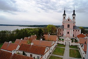
Camaldolese monastery on the lake
The Wigry is a lake in the Podlaskie Voivodeship in north-eastern Poland . Geographically it belongs to the western part of the Lithuanian Lake District . With an area of 21.7 km², it is the largest body of water in the Wigry National Park, founded in 1989 . It is surrounded by more than 40 smaller lakes. The main inflow and outflow is the Czarna Hańcza River . The bank is mainly overgrown with spruce and pine ; But there are also oaks , linden trees , alders , larches , birches and ash trees .
proof
- Włodzimierz Łęcki (Ed.): Canon Krajoznawczy Polski. Verlag Wydawnictwo PTTK “Kraj”, 2000. ISBN 83-7005-429-3 .
- M. Ambrosiewicz, W. Malinowska, M. Osewski, L. Wesołowska, Z. Zaborowski: Ścieżka edukacyjna "JEZIORA". Przewodnik. Krzywe: Wigierski Park Narodowy, 2001. ISBN 83-88344-24-2 .
- L. Trząski: Perły natury. Kielce: Wydawnictwo Videograf II, 2005.
Web links
Commons : Lake Wigry - collection of pictures, videos and audio files
- Wigry National Park website (Polish / English)
