Dolní Světlá (Mařenice)
| Dolní Světlá | ||||
|---|---|---|---|---|
|
||||
| Basic data | ||||
| State : |
|
|||
| Region : | Liberecký kraj | |||
| District : | Česká Lípa | |||
| Municipality : | Mařenice | |||
| Area : | 331.0221 ha | |||
| Geographic location : | 50 ° 50 ′ N , 14 ° 40 ′ E | |||
| Height: | 460 m nm | |||
| Residents : | 47 (March 1, 2001) | |||
| Postal code : | 471 57 | |||
| License plate : | L. | |||
| traffic | ||||
| Street: | Mařenice - Nová Huť | |||

Dolní Světlá , until 1946 Dolní Lichtenwald (German Nieder Lichtenwalde ) is a district of the municipality of Mařenice in the Czech Republic . It is located seven kilometers northeast of Cvikov on the German border and belongs to the Okres Česká Lípa .
geography
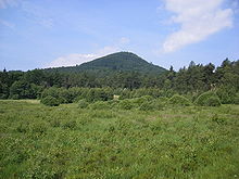
Dolní Světlá extends on the upper reaches of the Svitávka ( Zwittebach ) in the Lusatian Mountains . To the north rise the Sonneberg (627 m) and the Buchberg (652 m), in the northeast the Heideberg with the Rabensteinen ( Krkavčí Kameny , 543 m), to the east the Plešivec ( Plissenberg , 653 m), in the southeast the Kulich ( Gulichberg , 559 m) m) and the Soví vrch ( Olbenberg , 491 m), southwest of the Kamenný vrch ( Steinberg , 586 m), in the west the Kopřivnice ( Nesselsberg , 638 m) and the Čihadlo ( pieces mountain , 664 m) and northwest the Lausche ( Luž , 793 m).
Neighboring places are Waltersdorf and Saalendorf in the north, Jonsdorf in the northeast, Valy and Krompach in the east, Čtyřdomí in the southeast, Juliovka and Hamr in the south, Naděje and Rousínov in the southwest, Horní Světlá and Nová Huť in the west and Myslivny and Dolní Podluží in the northwest.
history
Forest glassworks have been found in the forests of the Lusatian Mountains since the beginning of the 14th century . In the following time the Bohemian kings settled the old border forest. Two blows left by the glassworks were probably colonized. The first written mention of the village of Lichtenwald , which belongs to Mühlstein Castle , took place in 1391. The settlement consisted of two spatially separated parts; the lower village was in the valley of the Zwittebach and the upper village in the basin of the spring of the Lichtenwalder brook flowing into it from the right. In 1532, the Berka von Dubá rulers united the Mühlstein rule with the Reichstadt rule . In 1612 Johann von Kolowrat -Nowohradsky acquired the rule of Reichstadt. His widow Anna Magdalena married Julius Heinrich von Sachsen-Lauenburg in 1632 . With the death of Duke Julius Franz von Sachsen-Lauenburg , the male line of the Dukes of Sachsen-Lauenburg died out in 1689. Through marriage and inheritance, the Reichstadt rule came to various owners; among them the Counts of Pfalz-Neuburg from the House of Wittelsbach , Ferdinand Maria of Bavaria , to the family of Archduke Ferdinand of Tuscany from the House of Habsburg-Lothringen and finally to Napoleon Franz Bonaparte . The residents of both districts initially made their living from logging, later home weaving became the main source of income.
In 1832 Nieder-Lichtewalde consisted of 144 houses with 932 German-speaking residents. There was a school, a border customs office and two grinding mills in the village. The parish was Groß-Mergthal . The inhabitants lived from farming, day labor, spinning and weaving. In 1834 a new school building was built for two-class lessons for the then 110 children in the village. Until the middle of the 19th century Nieder-Lichtewalde remained subject to the allodial rule of Reichstadt.
After the abolition of patrimonial made low-light Willewalde / Dolni Lichtenwald 1850 a district of the village of Upper light Hainewalde in Bunzlauer county and judicial district Zwickau. From 1868 Nieder-Lichtewalde belonged to the Gabel district . In 1869 there were 1,813 people living in the municipality of Ober-Lichtewalde. The poor economic conditions in the weaving village led to a strong emigration. In 1874 Nieder-Lichtewalde broke away from Ober-Lichtewalde and formed its own community. In 1890 the village consisted of 164 houses and had 766 German-speaking residents. In the course of the tourist development of the Lusatian Mountains, which began at the end of the 19th century, the place developed into a summer retreat, which was visited by day trippers from Bohemia and Saxony. At the junction to Ober-Lichtewalde the Hotel Schäfer was built , on the road to Ober-Lichtewalde the Gasthaus Winkler (later expanded to the Hotel Adler ), in the upper village called the Gasthof Zum Kaiser von Österreich (later Lindenhof ). But inns were also built outside the village. At the foot of the Rabensteine the Nieder-Lichtewalder Adolf Clemens Fähnrich opened a hut in 1877 and three years later made the rocks accessible to tourists with two lookout points; the Bohemian rock was named Ritterstein , the Saxon rock was called Falkenstein . In 1929, off the road to the guard on the edge of the Lausche forest, the Baude Neu-Brazil was built , but due to its unfavorable location it did not bring the expected number of guests. Before the First World War, Nieder-Lichtewalde also developed into a meeting place for winter sports enthusiasts; The first downhill section was slope 13 on the southeast slope of the Lausche. In 1922 the village was connected to the electricity network. The Czech place name was changed to Dolní Lichtenvald in 1924 . In 1930 there were 681 people living in the community of Nieder-Lichtenwalde with the layers of New Brazil and Rabenstein. After the Munich Agreement , it was incorporated into the German Reich in 1938; until 1945 the community had the official name Nieder Lichtenwalde and belonged to the district of Deutsch Gabel . In 1939 Nieder Lichtenwalde had 627 inhabitants. After the end of the Second World War, Dolní Lichtenwald came back to Czechoslovakia and was renamed Dolní Světlá in 1946. The border to Germany was closed. In 1946 and 1947, most of the German-Bohemian residents were expelled. The Nová Brazílie Baude was initially used as a children's rest home, the former Lindenhof was used as a barracks for the Czechoslovak border guard and the Schäfer Hotel under the new name Národní dům . In 1948 Dolní Světlá and Horní Světlá were united to form a municipality Světlá pod Luží and these were assigned to the Okres Nový Bor in the course of the abolition of the Okres Německé Jablonné. In 1950 only 171 people lived in Světlá pod Luží. At the beginning of the 1950s, the border with the GDR was barbed wire and all the houses in the upper village in the border zone, including the Lindenhof, as well as the Nová Brazílie rest home and the vacant Hotel Rabenstein, were demolished. Empty houses within the village were also demolished. In 1960 Světlá pod Luží came to Okres Česká Lípa . Since the 1960s, many of the uninhabited houses have been repaired as weekend houses. In 1966 the municipality of Světlá pod Luží was dissolved and its districts were added to the municipality of Krompach . Dolní Světlá has belonged to Mařenice as a district since 1981 .
In 1991 Dolní Světlá had 42 inhabitants. In 2001 the village consisted of 97 houses in which 47 people lived. Overall, the place consists of 112 houses, most of which are not permanently inhabited.
Local division
The district Dolní Světlá forms the cadastral district Dolní Světlá pod Luží. In the corridors of Dolní Světlá lie the deserted areas of Krkavčí Kameny ( Rabenstein ) and Nová Brazílie ( New Brazil ).
Attractions
- Chapel in the upper village, it was repaired in 1996
- numerous half-timbered houses
- Brazilka natural monument on the way to the Wache near Waltersdorf: the wet meadow on the southeast slope of the Lausche in the headwaters of the Zwittebach , which was drained by amelioration in 1988, proved unsuitable for agricultural use because of its wetness in places. In 1999 the bog, which is mainly located in the Czech Republic, was renatured on the state border as part of a bilateral project. On June 19, 1999 the 750 m long nature trail Lauschemoor / Brazilka was opened. Since 2002 the Brazilka has been protected as a natural monument on an area of 8.8 hectares. The name Brazilka is derived from the Nová Brazílie Baude, which stood on the edge of the meadow until the 1950s.
- Listen
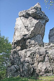
- Krkavčí Kameny / Rabensteine, two sandstone rocks on the German-Czech border; the Falkenstein ( Sokol ) is on the German side, the Sokolík ( Rabenstein ) on the Czech side. The Hotel Rabenstein , located at the foot of the rocks , remained unmanaged after the Second World War and was demolished in the 1950s.
- Na třináctce ski area ( slope 13 ) with lift operation
Web links
- The history of Dolní Světlá and Horní Světlá on the Mařenice Commune website
- Description of Dolní Světlá and Horní Světlá on luzicke-hory.cz
- Description of the Brazilka on luzicke-hory.cz
- Description of the raven stones on luzicke-hory.cz
Individual evidence
- ↑ http://www.uir.cz/katastralni-uzemi/675016/Dolni-Svetla-pod-Luzi
- ↑ http://www.zakonyprolidi.cz/cs/1947-123
- ^ Johann Gottfried Sommer , Franz Xaver Maximilian Zippe The Kingdom of Böhmen, Vol. 2 Bunzlauer Kreis, 1834, p. 265
- ↑ http://www.epravo.cz/vyhledavani-aspi/?Id=3529&Section=1&IdPara=1&ParaC=2
- ^ Michael Rademacher: German administrative history from the unification of the empire in 1871 to the reunification in 1990. Landkreis Deutsch Gabel (Czech. Jablonné v Podjestedí). (Online material for the dissertation, Osnabrück 2006).
- ↑ http://www.czso.cz/csu/2009edicniplan.nsf/t/010028D080/$File/13810901.pdf


