Muldenberg
|
Muldenberg
Municipality Grünbach
Coordinates: 50 ° 24 ′ 59 ″ N , 12 ° 24 ′ 3 ″ E
|
||
|---|---|---|
| Height : | 740 m | |
| Residents : | 197 | |
| Incorporation : | March 1, 1994 | |
| Incorporated into: | Grünbach | |
| Postal code : | 08223 | |
| Area code : | 037465 | |
|
Location of Muldenberg in Saxony |
||
Muldenberg is a district of the municipality of Grünbach in the Vogtlandkreis (Free State of Saxony ). It was called Mulde until 1934 and was then renamed Muldenberg . The place was incorporated into Grünbach on March 1, 1994.
geography
location
Muldenberg is located in the south-east of the Saxon part of the historical Vogtland , but in terms of natural space it already belongs to the Western Ore Mountains . To the south of the village, the Rote Mulde , the White Mulde and the Saubach unite to form the Zwickauer Mulde . The mouth area has been dammed up to form the Muldenberg dam since 1925 . This is at an altitude of 715 m. Muldenberg lies at an altitude between 690 m at the Muldenberg train station and 740 m in the village. Muldenberg is located in the Erzgebirge / Vogtland Nature Park .
Neighboring places
| Grünbach | Hammer bridge | |

|
Snail stone | |
| Schöneck / Vogtl. | Zwota | Klingenthal |
history
The area at the confluence of the Red and White Mulde rivers to form the Zwickauer Mulde was a dense jungle until around 1590. The Saxon Elector Johann Friedrich the Magnanimous acquired the Schönecker forests and the Kottenheide in 1533 . Between 1563 and 1582, Elector August I of Saxony expanded the electoral forest holdings through acquisitions by von Planitz and von Ellefeld . From 1579 raft ditches were built in order to better market the wood.
In the years 1586 to 1592 the first buildings were demonstrably erected in the area of today's Muldenberg. At the beginning of the 17th century, the Mulde forest workers and raftsmen settlement (also known as Muldenhäuser ) was built in the electoral Saxon state forest of the Upper Vogtland . It was an official village in the royal Saxon office of Voigtsberg .
In 1792 a second settlement called Muldenberg was founded on the private forest of Baron Trützschler von Falkenstein on the right of the Mulde , which was under the manorial rule of the manor Dorfstadt . Muldenberg belonged to the Electoral Saxon or Royal Saxon Office of Plauen until 1856 . After 1856 the area belonged to the Schöneck court office and from 1875 to the Auerbach administration . Around 1834 Mulde and other forest settlements belonged to the area. a. Saubachhäuser, Tannenhaus and Kottenheide to the Schönecker Waldgemeinde , after 1875 Muldenberg was one of them.
After the Chemnitz – Aue – Adorf railway ran through the valley of the upper Zwickauer Mulde from 1875, Mulde and Muldenberg received a station with the opening of the Falkenstein – Muldenberg railway in 1892. The Muldenberg station on both lines was built north of the settlements on Trützschlerisches territory.
Around 1900 the rural community "Mulde" consisted of the districts Mulde, Muldenberg, Saubachhäuser and Tannenhaus. In 1906, Kottenheide, located south of Mulde, was reclassified from Zwota to Mulde. Due to the favorable location in the headwaters of the Zwickauer Mulde, i. H. At the confluence of the Roter and Weißer Mulde with the Saubach to the Zwickauer Mulde, the Muldenberg drinking water dam was built between 1920 and 1925 south of the village .
In 1934 the name of the community “Mulde” was changed to “Muldenberg”. In 1939, the south-east of Schöneck / Vogtl was reclassified . lying Muldenberger municipality part Tannenhaus to Schöneck / Vogtl. The Saubachhäuser part of the community was no longer mentioned at this time. Presumably it is now in the area of the Muldenberg dam. On May 13, 1945, while ammunition was being sunk in the Muldenberg dam, an explosion occurred in which the barrier wall was badly damaged and 13 people died. The dam was rebuilt between 1946 and 1950.
As a result of the second district reform in the GDR , the municipality of Muldenberg became part of the Klingenthal district in the Chemnitz district (renamed the Karl-Marx-Stadt district in 1953 ), which was continued as the Saxon district of Klingenthal from 1990 and became part of the Vogtland district in 1996. In 1956 the Kottenheide district was reclassified to Schöneck / Vogtl. Until then, Muldenberg was one of the largest municipalities in Saxony in terms of area, with an area ranging from Hammerbrücke to Klingenthal and the Schneckenstein . However, 90% of the area was forested.
According to a citizen survey carried out in the early 1990s, the majority of residents voted for incorporation into the community of Grünbach, which is four kilometers away, and against the neighboring village of Hammerbrücke, which is only two kilometers away. Muldenberg has been part of the Grünbach community since March 1, 1994.
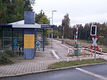
Since the construction of the Eibenstock dam , Muldenberg station has increasingly lost its importance as a separation station , as the Chemnitz – Aue – Adorf line was interrupted in 1975 between Wolfsgrün and Schönheide Ost station in Schönheiderhammer . In 1983 travel to Schönheide Ost was discontinued, and in 1995 freight traffic as well. After the points have been expanded, the Förderverein Westsächsische Eisenbahnen eV (FVWE) is working on reconnecting the line from Muldenhammer to Schönheide Süd, which has been used as a museum railway since 2005 . After the Muldenberg train station was canceled as a stop by the ZVV in 2014 , the main platform and the passenger crossing were dismantled. Since then, Muldenberg only has the “Muldenberg Floßplatz” stop, which was inaugurated in 2001, but which is centrally located in the town.
Infrastructure
The Muldenberg station was at the confluence of 1,892 railway Falkenstein-Muldenberg to the railway line Chemnitz-Aue-Adorf opened. In 2014, the train station located about one kilometer north of the village was canceled as a stop by the public transport association Vogtland . The Muldenberg Floßplatz stop has existed in the center of the village since 2001, from the Vogtland Railway in the direction of Klingenthal and Auerbach / Vogtl. is served.
Attractions
- Muldenberg dam
The headwaters of the Zwickauer Mulde are located in the forest area around Muldenberg. The Muldenberg dam , built between 1920 and 1925, has the longest dam in Saxony with a barrier wall of 525 meters and one of the longest quarry stone barriers in Europe. It is located at an altitude of 715 meters above sea level.
- Raft ditch and rafting
In order to better transport the wood from the electoral Saxon forests of the upper Vogtland to the Halle / Leipzig area , the construction of raft ditches began in 1579. Around Muldenberg a. a. the "Obere Floßgraben" (from 1579), the "Kielfloßgraben" to the Kiel near Mühlleithen (1632) and the "Untere Floßgraben". The latter had a length of 7.15 kilometers and a gradient of six meters. By resolution of the Muldenberg municipal council, a section of the Lower Floßgraben was made flowable again in 1991 and declared a technical monument . Its dam is completely preserved. Today the ditch only leads from the compensation basin of the Muldenberger Dam to the former Leonhardt sawmill in Hammerbrücke Wasser.
Muldenberg became famous with the revival of the log rafting , for which the repaired Lower Floßgraben is used as a display raft route. The "Vogtland Rafting Association Muldenberg eV", founded in 1993, organizes show rafting events annually on the Ascension weekend to maintain the customs. The association also operates charcoal burning, the kilns of which can be viewed.
- Kammloipe
Muldenberg is located on the Kammloipe , one of the longest and most snow-sure trails in Germany .
Web links
- Muldenberg in the Digital Historical Directory of Saxony
- Muldenberg on the website of the community Grünbach
Individual evidence
- ↑ Muldenberg on the website of the community Grünbach ( Memento from November 4, 2016 in the Internet Archive )
- ^ History of rafting in and around Muldenberg
- ↑ Mulde in the "Handbuch der Geographie", p. 437
- ↑ The Rittergut Dorfstadt on www.sachsens-schloesser.de
- ^ Karlheinz Blaschke , Uwe Ulrich Jäschke : Kursächsischer Ämteratlas. Leipzig 2009, ISBN 978-3-937386-14-0 ; P. 76 f.
- ^ The Auerbach administration in the municipality register 1900
- ↑ Kottenheide on gov.genealogy.net
- ^ Tannenhaus in the Digital Historical Directory of Saxony
- ↑ Saubachhäuser in digital Historical Gazetteer of Saxony
- ↑ Kottenheide in the Digital Historical Directory of Saxony
- ^ Muldenberg on gov.genealogy.net
- ↑ Homepage of the Friends of the Westsächsische Eisenbahnen eV
- ^ Chemnitzer Verlag und Druck GmbH & Co. KG: Vogtlandbahn - Muldenberg loses a stop. In: Freiepresse.de. Retrieved October 19, 2016 .
- ↑ The Obere Floßgraben on the website of the community Grünbach ( Memento from November 4, 2016 in the Internet Archive )
- ↑ The raft ditch system on the website of the community Grünbach ( Memento from November 4, 2016 in the Internet Archive )
- ↑ website rafters Association Muldenberg


