Lungwitzbach
| Lungwitzbach | ||
|
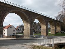
The Lungwitzbach in Niederlungwitz. |
||
| Data | ||
| Water code | EN : 5416 | |
| location | Ore Mountains Basin | |
| River system | Elbe | |
| Drain over | Zwickauer Mulde → Mulde → Elbe → North Sea | |
| source | origin | |
| Source height | 380 m above sea level NN | |
| muzzle | Glauchau coordinates: 50 ° 50 ′ 4 ″ N , 12 ° 33 ′ 2 ″ E 50 ° 50 ′ 4 ″ N , 12 ° 33 ′ 2 ″ E |
|
| Mouth height | 230.4 m above sea level NN | |
| Height difference | 149.6 m | |
| Bottom slope | 6.2 ‰ | |
| length | 24.1 km | |
| Catchment area | 138.96 km² | |
| Discharge at the Niederlungwitz A Eo gauge : 128 km² Location: 2.8 km above the mouth |
NNQ (06/07/1988) MNQ 1965/2005 MQ 1965/2005 Mq 1965/2005 MHQ 1965/2005 HHQ (08/13/2002) |
30 l / s 449 l / s 1.42 m³ / s 11.1 l / (s km²) 22.9 m³ / s 98.5 m³ / s |
| Medium-sized cities | Glauchau | |
| Small towns | Oberlungwitz , Lichtenstein (Saxony) , Hohenstein-Ernstthal | |
| Communities | Erlbach-Kirchberg , Bernsdorf , St. Egidien | |
The Lungwitzbach is a flowing body of water in the Ore Mountains Basin and a tributary of the Zwickauer Mulde . The water gets its name from the nearby places Oberlungwitz and Niederlungwitz .
History
In 1143 one of the heights to the right of the lower reaches of the Lungwitzbach is documented as "mons Crostawitze" (the exact location is probably unknown). One of the oldest documents in this area. Endings in "witze" indicate a Slavic settlement here.
course
After its source in the Lugau district of Ursprung , the stream flows to the northwest, before it flows to the west from Oberlungwitz. The Lungwitzbach has a flood channel near Oberhermsdorf. Between Sankt Egidien and Niederlungwitz the course of the river turns to the northwest. Between Hermsdorf and Glauchau , the Dresden – Werdau railway line uses the Lungwitzbach valley. In the upper reaches, the Neuoelsnitz – Wüstenbrand railway line , which existed until 2003, used the valley.
Order of the tributaries with the point of discharge:
- from right: Kupfermühlenbach in Oberlungwitz
- from right: Höllenbach in Oberlungwitz
- from right: Steinberger Bach (?) in Oberlungwitz (source in Wüstenbrand on the southern edge of the Rabensteiner ridge )
- from left: Hirschgrundbach in Oberlungwitz (source near Erlbach-Kirchberg rises (Wüstes Gut Vorell))
- from left: Kirchberger Dorfbach in Oberlungwitz (297 m above sea level)
- from left: Hegebach (Oelsnitzbach) in Oberlungwitz (originates in the Oberoelsnitz area of the city of Oelsnitz / Erzgeb. )
- from right: Goldbach near the sewage treatment plant
- from right: Hüttengrundbach in Hermsdorf (coming from the Haynholz )
- from left: Bernsdorfer Bach (?) in Hermsdorf
- from left: Rödlitzbach in Rüsdorf (rises in the Neudörfler Wald near Heinrichsort and drains Lichtenstein / Sa.)
- from right: Kuhschnappelbach above St. Egidien (which feeds the St. Egidien dam )
- from left: Lichtensteiner Bach (?) on Auersberg in St. Egidien
- from left: Tempelbach below St. Egidien (originates in the Rümpfwald )
- from right: Lobsdorfer Bach above Niederlungwitz
- from right: Rottelsbach above Niederlungwitz, rises northeast of the Reinholdshain-Ebersbacher Wald / Forst near the A4 motorway
A few meters north of the Glauchau train station , the Lungwitzbach flows into the Zwickauer Mulde. There is also the Scheer mill of Reinholdshain .
fauna
At the beginning of the 20th century, white fish such as minnows , gudgeons and rudds as well as bearded gobies , eels , more rarely pike , tench , carp and the brook lamprey were found. Today the chub is very common. The kingfisher can also be seen again because it finds its food source in the form of small fish. The gray heron is also being observed again.
Flood
The Lungwitzbach has been called "the wild brook" from time immemorial. As a result of the recurring flood events, a flood retention basin has already been built on a tributary (Kirchberger Dorfbach) and a second one (on Rödlitzbach) is being sought.
additional
With a catchment area of around 140 square kilometers, the Lungwitzbach is one of the largest rivers in the Ore Mountains Basin . The approx. 24 km long watercourse has a longitudinal gradient of around 160 m, of which 100 meters in altitude are accounted for by the upper course - to the mouth of the Hegebach. From there, the Lungwitzbach is a first-class flowing water and is in the care of the state dam administration of Saxony .
literature
- Wolfgang Erdtel: "Goat's milk and red noses, childhood at the Lungwitzbach", second part, Norderstedt, 2004 (childhood in Niederlungwitz)
Individual evidence
- ↑ Hydrological Handbook. (PDF; 637 kB) Part 3 - Main aquatic values. Free State of Saxony - State Office for Environment and Geology, p. 53 , accessed on December 25, 2017 .
- ^ Walter Schlesinger , edited by Thomas Lang: Contributions to the history of the city of Glauchau. Edited by Enno Bünz. Thelem Verlag, Dresden 2010, p. 53.

