Schlemabach
| Schlemabach | ||
|
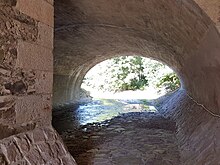
Edged bed of the Schlemabach next to the main road in Niederschlema. |
||
| Data | ||
| Water code | DE : 54134 | |
| location | Saxony | |
| River system | Elbe | |
| Drain over | Zwickauer Mulde → Mulde → Elbe → North Sea | |
| origin | northwest of Griesbach 50 ° 36 ′ 34 ″ N , 12 ° 35 ′ 54 ″ E |
|
| Source height | about 573 m above sea level NN | |
| muzzle | at Bad Schlema train station in the Zwickauer Mulde Coordinates: 50 ° 37 ′ 12 ″ N , 12 ° 40 ′ 50 ″ E 50 ° 37 ′ 12 ″ N , 12 ° 40 ′ 50 ″ E |
|
| Mouth height | 325 m above sea level NN | |
| Height difference | about 248 m | |
| Bottom slope | about 25 ‰ | |
| length | 10 km | |
| Catchment area | 28.6 km² | |
The Schlemabach , also known as Schlema or Knappschaftsbach for short , is an approximately 10 km long left tributary of the Zwickauer Mulde in the Saxon Ore Mountains .
geography
course
The stream rises in the western part of the Griesbach district and flows south towards Lindenau , where it takes up the Lindenauer Bach. Here it turns to the east, flows through the Meierteich and the Neuer Teich, which is also called the Pochwerk (s) teich because of the Siebenschlehen stamping mill. Then it runs parallel to the B 169 Schneeberg in the south and then crosses the Bad Schlemaer districts Ober- and Niederschlema. About 100 m northeast of the Bad Schlema train station, the stream flows into the Zwickauer Mulde, after having absorbed the pit water from the Markus-Semmler-Stolln a few meters beforehand .
Tributaries
- Lindenauer Bach (right)
- Griesbach (left)
- Outflow Fürstenstolln
- Silberbach (left)
- Markus-Semmler-Stolln (left)
particularities
The depletion-like uranium mining in the area of the Oberschlema radium bath , which began after 1946 and partially reached into the cellars of the residential buildings, led to large-scale subsidence and finally to the demolition of the town center. The Schlemabach was also affected, which poured into the mine workings several times and almost brought mining to a standstill. In parts it was therefore led in wooden receiving waters . From 1952 the brook was moved to the south of the deformation area and partially piped. The length of the relocation, popularly known as “Millions Stream”, was about 3 km. It started south of Schneeberg, was first designed as a slope ditch parallel to the B 169, partially ran parallel to Markus-Semmler- and Richard-Friedrich-Straße, then crossed the Floßgraben , picked it up and finally cascaded back in behind the deformation area old streambed led. Even after 1959, the floodlights to keep the pits water in operation continued to operate. Between 1965 and 1989, an average of 7.5 million m³ of water was pumped annually, which was either fed to the Gleesberg waterworks or fed into the Schlemabach floodlight. Due to the persistent subsidence, these had to be repaired again and again.
The Schlemabach was already the subject of renaturation measures in the 1990s. During the floods in 2002 , the slope ditch broke in Schneeberg in the area of Auer Straße and led to the B 169 being flooded , which could not be used for two weeks. The damage here alone amounted to 4 million euros. Subsequently, the stream was completely relocated back to its old valley. Watertight substructures prevent drainage into the mine workings.
literature
- Wismut GmbH (Hrsg.): Chronicle of WISMUT . Chemnitz 2002.
See also
Web links
Individual evidence
- ^ Chronicle of the city of Schneeberg, 2002 , accessed on October 19, 2016


