
Ebersbrunn (light fir)
|
Ebersbrunn
Municipality Lichtentanne
Coordinates: 50 ° 38 ′ 59 ″ N , 12 ° 26 ′ 5 ″ E
|
||
|---|---|---|
| Height : | 385–469 m above sea level NN | |
| Area : | 7.13 km² | |
| Residents : | 1230 | |
| Population density : | 173 inhabitants / km² | |
| Incorporation : | January 1, 1997 | |
| Postal code : | 08115 | |
| Area code : | 037607 | |
Location of Ebersbrunn in Saxony |
||

Ebersbrunn is a part of the municipality Lichtentanne in the district of Zwickau in Saxony . Approx. 1230 inhabitants live in Ebersbrunn on an area of 7.13 km².
geography
.jpg)
Ebersbrunn is located in the natural area of the Ore Mountains Basin (Upper Pleißeland). In the corridor, the Pleiße rises in the Drei-Linden-Brunnen at 443 m above sea level. NN . After about 90 kilometers and a 340 meter gradient in Leipzig, it joins the White Elster .
The place is away from the other Lichtentanner districts in the extreme south of the municipality, directly southwest of the district town of Zwickau . The next town to the northeast is the Zwickau district of Hüttelsgrün , which was created around 1900 as a district of Ebersbrunn. Rottmannsdorf lies to the east- northeast, Voigtsgrün in the south and Hauptmannsgrün in the southwest . In the northwest are the districts of Schönfels and Lichtentanne, directly to the north of Stenn . To the south of the train station and north-east of the motorway junction is the surveying point 137 of the Royal Saxon Triangulation , which was built in the 19th century .
history

The place was first mentioned in 1118 in a border document of the Naumburg bishop Dietrich I. In the course of the German settlement in the east , Franconian and Hessian settlers expanded the Slavic farming village, and clearing it became a forest hoof village . Ebersbrunn an der Pleiße moated castle , which has since been abandoned, already existed before 1300, and a mill is documented for 1342. The village was under the care of Zwickau in the middle of the 15th century, the manorial rule lay with the Neuschönfels manor . The medieval church was replaced by the current structure in 1820.
Until 1856 Ebersbrunn belonged to the Electoral Saxon or Royal Saxon Office of Zwickau in the Erzgebirge district . In 1856 the place was affiliated to the Zwickau court office and in 1875 to the Zwickau administrative authority . The landowner and later member of the state parliament, Friedrich August Barth , who lived in the neighboring village of Stenn , was one of the founders of the Agricultural Association in Ebersbrunn in 1849. He took over its chairmanship in 1862. Towards the end of the 19th century, the community was connected to the Zwickau – Falkenstein railway in 1893 .
The Americans marched into Ebersbrunn on April 17, 1945. In June they handed over the command to the Red Army . The community was now in the Soviet Zone , from which the GDR emerged in 1949 . As part of the administrative reform , the district of Zwickau-Land in the district of Karl-Marx-Stadt was created in 1952 , which was continued as the Saxon district of Zwickau from 1990 and was added to the district of Zwickauer Land in 1994 . After the fall of the Wall and reunification , the communities of Stenn and Schönfels merged with Lichtentanne on January 1, 1996 , followed a year later on January 1, 1997 by the Ebersbrunn community with its Hüttelsgrün district, which was created around 1900 . Two more years later Hüttelsgrün was transferred to Zwickau on January 1, 1999. As a result of the decline in the birth rate, the primary schools in Ebersbrunn and Schönfels were closed in 2001. Ebersbrunn has been part of the Lichtentanne municipality in the Zwickau district since 2008.
Ebersbrunn has a church, two hairdressers, two restaurants, a beverage market, a doctor, a nursery, a bakery and a guesthouse with a vinotheque.
Population development
| year | Residents |
|---|---|
| 1834 | 632 |
| 1871 | 1456 |
| 1890 | 1785 |
| 1910 | 2110 |
| 1925 | 2028 |
| 1939 | 2313 |
| 1946 | 2470 |
| 1950 | 2516 |
| 1964 | 2048 |
| 1990 | 1583 |
| 1996 | 1877 |
In 1551, 46 possessed men , 13 housekeepers and 28 residents worked in Ebersbrunn . Around two centuries later, the number of farms in 1764, a year after the end of the Seven Years' War , was 59 owned men and 25 farms.
In the almost 40 years from the accession of the Kingdom of Saxony to the German Customs Union until the founding of the empire , the number of inhabitants more than doubled, from around 630 to almost 1500 inhabitants. From the turn of the century to the interwar period, the population fluctuated around 2100 and rose to over 2300 by the Second World War. After the war, the community had over 2500 inhabitants at times, the number of which fell by almost 1000 in the following 40 years Ebersbrunn (with the district of Hüttelsgrün) another slight increase in population.
traffic
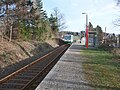
The federal motorway 72 runs south of the locality with the junction Zwickau-West , at which the state road 293 branches off and runs east of Ebersbrunn north to federal road 173 . The place has a stop on the Zwickau – Falkenstein railway line .

Ebersbrunn stop (2016)
Ebersbrunn stop with Vogtlandbahn (2016)
.JPG)
.JPG)
Individual evidence
- ↑ a b Information on Ebersbrunn on the website of the municipality of Lichtentanne (accessed on February 7, 2014)
- ^ The Neuschönfels Castle at www.sachsens-schlösser.de
- ^ Karlheinz Blaschke , Uwe Ulrich Jäschke : Kursächsischer Ämteratlas. Leipzig 2009, ISBN 978-3-937386-14-0 ; P. 64 f.
- ↑ The Zwickau administrative authority in the municipal register 1900
- ↑ a b Information for 14 1 93 090 Ebersbrunn municipality. In: Regional Register Saxony. State Statistical Office of the Free State of Saxony , accessed on February 10, 2014 .
- ^ Pension zum Hollerbusch. In: ferien-hollerbusch.de. Retrieved October 2, 2018 .
- ↑ Ebersbrunn in the Digital Historical Directory of Saxony
literature
- Werner Leichsenring: Family book for the parish of Ebersbrunn (with Voigtsgrün ) 1580–1807 based on an index from around 1970. Copy of the family cards . Leipzig: German Central Office for Genealogy 1994
