Lößnitzbach (Zwickauer Mulde)
|
Loessnitzbach Affalterbach |
||
|
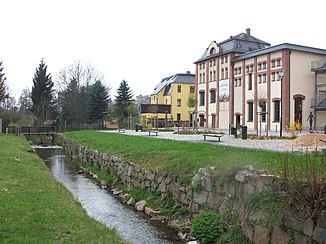
The Lößnitzbach in Lößnitz |
||
| Data | ||
| Water code | DE : 54132 | |
| location | Germany, Saxony | |
| River system | Elbe | |
| Drain over | Zwickauer Mulde → Mulde → Elbe → North Sea | |
| source | in Streitwald (Lößnitz) 50 ° 39 ′ 20 ″ N , 12 ° 46 ′ 15 ″ E |
|
| Source height | about 582 m above sea level NHN | |
| muzzle | Coordinates in Aue : 50 ° 36 '5 " N , 12 ° 41' 33" E 50 ° 36 '5 " N , 12 ° 41' 33" E |
|
| Mouth height | about 337 m above sea level NHN | |
| Height difference | about 245 m | |
| Bottom slope | about 24 ‰ | |
| length | 10.4 km | |
| Catchment area | 28.4 km² | |
| Small towns | Loessnitz , Aue | |
The Lößnitzbach is an approximately 10 km long right tributary of the Zwickauer Mulde in the Saxon Ore Mountains .
course
The stream has its source in the Streitwald district of Loessnitz . From there, the stream flows mainly in a south-west direction. First it flows through Affalter , after which the upper section was also called Affalterbach. The Waldhufendorf extends with its buildings for about 4 km along the stream. After a small bend, it passes the center of the mountain town of Lößnitz, founded around 1170, to the south. At Niederlößnitz he takes the Aubach from the left.
Then it squeezes together with the B 169 and the Chemnitz – Adorf railway line through a deep valley that the stream cut into the contact zone of the granite body of Aue. In general, the brook, as well as the inflowing Aubach and its tributaries Hintere Aue , Vordere Aue and Dittersdorfer Bach , have shaped the area strongly. Hollow and notched valley valleys make up a large part of the area, so that the area is also known as Lößnitzgetäler . The natural area is called Lößnitz valley and Riedel area .
After the valley opens, it flows past the Erzgebirgsstadion , home of the Erzgebirge Aue . North of the Auer district cell (Aue) , roughly at the monastery church , the dragged river flows into the Zwickau Mulde.
Tributaries
- Karl-Neubert-Bächel (left)
- Hasenschwanzbach (right)
- Aubach (left)
Economic use
The water of the stream was used by several mills. The Landrock mill is recorded north of Lößnitz. The Elias mill was just behind the inlet of the Aubach in Niederlößnitz. The hammer mill stood about 200 m further south and a further 800 m downstream was a paper mill , which was built in 1584 from a disused hammer mill.
Several unnamed mills are also shown in Affalter.
See also
literature
- Loessnitzbachtal. In: Between Zwickauer Mulde and Geyerschem Wald (= values of our homeland . Volume 31). 1st edition. Akademie Verlag, Berlin 1978, p. 164 f.
Web links
Individual evidence
- ↑ a b Saxony Atlas
- ↑ a b Map of the Saxony water balance portal
- ↑ Loessnitz . In: August Schumann : Complete State, Post and Newspaper Lexicon of Saxony. 5th volume. Schumann, Zwickau 1818, p. 811.
- ↑ Natural space map service of the Landschaftsforschungszentrum eV Dresden ( information )
- ↑ Michael Wetzel : The Schönburg Office Hartenstein 1702–1878: social structure, administration, economic profile. In: Writings on Saxon History and Folklore Volume 10, Leipzig: Leipziger Universitätsverlag, 2004, p. 365.
- ^ Saxon miles sheets. Freiberg copy, sheets 187 and 188, 1790 ( digitized version )
