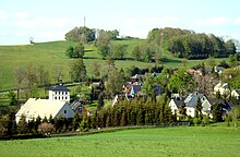
Top pane
|
Top pane
City of Scheibenberg
Coordinates: 50 ° 32 ′ 0 ″ N , 12 ° 54 ′ 0 ″ E
|
||
|---|---|---|
| Height : | 621 (590-725) m | |
| Area : | 3.52 km² | |
| Residents : | 287 (May 9, 2011) | |
| Population density : | 82 inhabitants / km² | |
| Incorporation : | January 1, 1994 | |
| Postal code : | 09481 | |
| Area code : | 037349 | |
|
Location of Oberscheibe in Saxony |
||
The village of Oberscheibe is part of the town of Scheibenberg in the Saxon Ore Mountains .
history
The settlement of the double-row forest hoof village Oberscheibe, like that of the neighboring villages of Markersbach , Raschau and Schwarzbach, is set for the end of the 12th century. The first documentary mention of the village of Schybe can only be traced back to 1401, when it was sold by the County of Hartenstein to the Grünhain monastery . As a result, however, the territory was redeemed again by the County of Hartenstein.
When silver was found on the Scheibenberg at the beginning of the 16th century , the incoming miners also settled in Oberscheibe. The resulting overpopulation led to the founding of the neighboring mountain town of Scheibenberg in 1522 . When in 1559 the Upper Forest rule of Hartenstein was sold by the Schönburger to the Saxon Elector August , Oberscheibe became part of the Electorate of Saxony . According to the Schoenburg inheritance book , Scheuba had 31 possessed men in 1559, but the timber regulations of the Crottendorf Office only mentions 24 possessed men for 1560: 14 wealthy on 3¼ hooves and 10 cottagers. In 1732 14 wealthy people, 19 house owners and 6 housemates are taxed.
Oberscheibe owned a hereditary court with its own brewery (today the Fiedler private brewery ), its own angle school and two mills driven by Scheibner Bachel . Many preserved heaps and mouth holes are evidence of the once brisk mining activity in the village. In 1478 the “Maria Magdalena” colliery on the Scheibenberg can be traced. The iron ore mine "Father Abraham" supplied the iron hammer mills in the area for centuries , especially the hammer mill in Obermittweida in the valley of the Great Mittweida . Other mines were the “Alte Hilfe Gottes Fundgrube” and the “Andreas Schacht”.
On the road to Crottendorf there is a lime quarry and a lime works , whose annual production around 1820 was given as around 1000 barrels of lime. In 1965 45,000 tons of lime, most of which was burned and processed into fertilizer lime, were spread by the 45 workers at the company.
The Oberscheibner residents originally went to church in Markersbach, but were re-parish to Scheibenberg in the 16th century.
Oberscheibe was incorporated into Scheibenberg on January 1st, 1994.
administration
Oberscheibe has a five-person local council. The head of the village is Heike Flath, HR clerk (FWBF), deputy is Jens Ingo Kreißig, employee (CDU).
Reinhold Klecha, pensioner (FWBF) and Jens Ingo Kreißig, employee (CDU) were elected to the city council of the mountain town of Scheibenberg.
Population development
|
|
|
literature
- Top pane . In: August Schumann : Complete State, Post and Newspaper Lexicon of Saxony. 7th volume. Schumann, Zwickau 1820, p. 658 f.
- Lothar Riedel : Father Abraham and Oberscheibe . In: Erzgebirgische Heimatblätter 39 (2017), Heft 4, pp. 8-10. ISSN 0232-6078
Web links
- Oberscheibe in the digital historical place directory of Saxony
- Private homepage via Oberscheibe
- Literature from and about Oberscheibe in the Saxon Bibliography
Individual evidence
- ↑ Small-scale municipality sheet for Scheibenberg, city. (PDF; 0.23 MB) State Statistical Office of the Free State of Saxony , September 2014, accessed on January 30, 2015 .
- ↑ cf. Oberscheibe in the digital historical place directory of Saxony


