Barby
| coat of arms | Germany map | |
|---|---|---|
|
Coordinates: 51 ° 58 ' N , 11 ° 53' E |
|
| Basic data | ||
| State : | Saxony-Anhalt | |
| County : | Salzlandkreis | |
| Height : | 51 m above sea level NHN | |
| Area : | 152.75 km 2 | |
| Residents: | 8323 (Dec. 31, 2019) | |
| Population density : | 54 inhabitants per km 2 | |
| Postcodes : | 39249, 39240 ( Breitenhagen , Groß Rosenburg, Lödderitz, Sachsendorf, Zuchau) |
|
| Primaries : | 039298, 03928 (Gnadau) , 039294 (Breitenhagen, Groß Rosenburg, Lödderitz) , 039295 (Sachsendorf, Zuchau) | |
| License plate : | SLK, ASL, BBG, SBK, SFT | |
| Community key : | 15 0 89 026 | |
| LOCODE : | DE BBY | |
| NUTS : | DEE0C | |
City administration address : |
Market 14 39249 Barby |
|
| Website : | ||
| Mayor : | Torsten Reinharz ( independent ) | |
| Location of the town of Barby in the Salzlandkreis | ||
Barby is a town in the Salzlandkreis in Saxony-Anhalt . Until the city was rebuilt on January 1, 2010 from the municipalities of the former Elbe-Saale administrative community (except Gnadau ), the city was called Barby (Elbe) . Gnadau was incorporated into Barby on September 1, 2010.
geography
Barby lies on the left bank of the Elbe . About 3 kilometers southeast of the city the Taube flows into the Saale and this into the Elbe. The city forms the western border of the Middle Elbe Biosphere Reserve . To the north-west and south-east of the city are lakes created from former gravel mining.
City structure
Barby consists of the districts Colphus, Monplaisir, Weinbergsiedlung and Zeitz as well as the following villages:
| Postcode | Locality | Residents | Districts |
The localities of Barby (clickable map) |
|---|---|---|---|---|
| 39240 | Breitenhagen | 492 | Alt Tochheim | |
| 39249 | Glinde | 304 | - | |
| 39249 | Gnadau | 523 | Döben | |
| 39240 | Gross Rosenburg | 1680 | Klein Rosenburg | |
| 39240 | Lödderitz | 230 | Rajoch | |
| 39249 | Pommelled | 644 | New settlement and Zackmünde | |
| 39240 | Saxon village | 307 | Patzetz | |
| 39249 | Tornitz | 566 | Werkleitz | |
| 39249 | Wasps | 229 | - | |
| 39240 | Zuchau | 318 | Colno |
Dialect border
Barby is located immediately south of the Benrath line and thus at the transition from the High German - more precisely: the East Central German dialects to the Low German language . The Benrath line meets the Elbe here.
history
Barby was first mentioned on April 23, 961 in a document from King Otto I as "barbogi", which in Old High German means "place on the forestless river bend", literally: "bare arch". The city was surrounded by a wall with five city gates. Remnants of the city wall are still preserved. The Barby Territory was made an imperial county in 1497 and was owned by the Counts of Barby . These introduced the Lutheran Reformation in 1540 . After the death of the last Count of Barby in 1659, Barby fell to Duke August von Sachsen-Weißenfels , whose son Heinrich had the castle built from 1687-1715.
In 1660 Maria Kühne from Barby, called Fischer, widow of Andres Grosse, maid in the house of the ferry master Palm Gräfe, 73 years old, was involved in a witch trial as part of the witch hunt on charges of sickness . In the districts of Breitenhagen and Glinde there were another five proceedings.
For decades in the 18th century, Barby was the seat of the Evangelical Brethren Congregation (Herrnhuter Brothers Unity) and the leadership of the Moravian ’s worldwide mission . In 1749 the " Seminarium Theologicum " ( seminary ) of the Brethren was moved from Lindheim to Barby. One of the most famous students was Friedrich Schleiermacher , who attended the school from 1785 to 1787.
In October 1806 the French corps Bernadotte crossed the Elbe at Barby ("Heerstraße") on its way from Halle to Lübeck.
In the second half of the 19th century, Adolf Krummacher became the senior pastor in Barby, who became known as a hymn poet (“ Star I look at ”) and author of the student song “And when the swarm got lost”.
From 1920 the Maizena works in Barby were built.
On September 30, 1928, the Zeitz-Monplaisir manor was united with the city of Barby. The Zeitz and Monplaisir residential areas became part of the city of Barby.
At the end of the Second World War , the Protestant pastor Ludwig Fuchs, at the risk of his life, prevented the forcible capture of the city by US troops by affixing church flags and white cloths. According to another source, US ground troops captured the banks of the Elbe on April 13, 1945 after street fighting in Barby and were then able to build a bridgehead towards Zerbst on the other side of the Elbe.
- Population development
In 1970 Barby had 6320 inhabitants, in 2005 there were only 4586 inhabitants.
politics
City council
In the local elections on May 25, 2014, 20 city councilors were elected. The election resulted in the following composition of the city council:
| Party / list | Seats 2014 |
| CDU | 6th |
| left | 2 |
| SPD | 2 |
| FDP | 1 |
| Green | 1 |
| Groups of voters | 6th |
| Individual applicants | 2 |
| total | 20th |
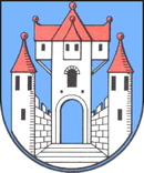
coat of arms
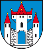
The coat of arms was approved on March 25, 1998 by the Magdeburg Regional Council.
Blazon : "In blue a silver castle with tinned, black grooved walls and three towers with red, golden pinned pointed roofs; the elevated, larger central tower (guard tower) with an open arched gate, black arched window opening and three oriels with red, golden pinned roofs and black rectangular window openings , in the middle bay two, in the outer bay each one; the outer towers each with three (2: 1) black arched window openings. In front of the gate silver steps. "
The coat of arms was revised in 1998 by the Magdeburg local heraldist Jörg Mantzsch in the course of the flag approval after objection by the local authority.
Town twinning
Partnerships exist with:
- the city of Schöppenstedt in Lower Saxony (since 1990)
- with the Lithuanian community of Aukštadvaris near Trakai (since 1994)
- with the Polish municipality of Pruchnik in the Subcarpathian Voivodeship
Culture and sights

Buildings
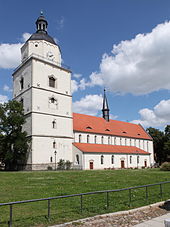
- St. John's Church
- St. Mary's Church
- Chapel of St. Georgii
- lock
- The little princess
- The prince
- city wall
-
Elbe bridge
In Barby, the railway line from Berlin to Blankenheim crosses the Elbe on a 757 m long bridge including the floodplain. Operation on the route is permanently suspended.
Historical monument
- Memorial from the 1950s on Schloßplatz for the local eight, mostly Jewish, victims of fascism
Economy and Infrastructure
traffic
Barby is connected to Schönebeck (Elbe) , Calbe (Saale) and the nearby Gierseilferry over the Elbe with Güterglück and the B184 .
The Barby ferry and the Breitenhagen ferry across the Elbe are connected to the Groß Rosenburg ferry across the Saale by the 3-ferry tour, a 24 km long circular route.
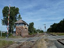
The only passenger station in Barby today is the Sachsendorf (b Calbe) station on the Magdeburg – Leipzig railway line , which is served hourly by regional trains. The Barby station on the Berlin – Blankenheim line was served by a regional train on the Magdeburg - Schönebeck (Elbe) - Güterglück - Bad Belzig line until 2003 . However, passenger traffic on this route has now been discontinued. The station building, which was built as a yellow brick building in the style typical of the imperial era, is increasingly falling into disrepair.
From 1884 to 1922 the Patzetz – Breitenhagen horse-drawn tram ran in what is now the city of Barby , connecting the districts of Patzetz , Groß Rosenburg, Klein Rosenburg and Breitenhagen to the Sachsendorf station.
The port of Barby is located on the Elbe in the north of the city.
Established businesses
Since the 1920s, the Maizena works Barby produced glucose and corn starch; the factory was called "VEB Maisan-Werke Barby" in the GDR. In 1993, the Cerestar company ( taken over by Cargill in 2002) built a new wheat starch plant next to the plant closed in 1992 . In addition, the Maxit Baustoffwerke company is located in Barby, which is now part of Saint-Gobain Weber . The Elbe-Saale Clinic , a rehabilitation clinic for heart and circulatory diseases, is also worth mentioning .
Personalities
sons and daughters of the town
- Friedrich Gottlieb Heinrich Fielitz the Elder (1749–1820), physician and author
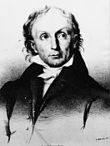
- Jakob Friedrich Fries (1773–1843), philosopher
- Gottfried Renatus Häcker (1789–1864), pharmacist, botanist and conservator
- Heinrich von Schlieckmann (1800–1869), politician, lawyer, member of the Prussian manor house
- Gustav Rebling (1821–1902), composer and conductor
- Johann Gottfried Dietze (1823–1888), manor owner and politician, MdR, MdL
- Karl Julius Keim (1823–1906), doctor in Magdeburg, medical and humorous writer
- Adolph von Dietze (1825–1910), farmer, politician
- Rudolph Palme (1834–1909), organist, composer, publisher and organ auditor in Magdeburg
- Heinrich Mundlos (1836–1928), inventor and manufacturer of sewing machines
- Max Sering (1857–1939), political economist
- Georg Dittmann (1871–1956), classical philologist
- Walter Conrad (1892–1970), lawyer and politician (FDP)
- Richard Würpel (1903–1987), painter and art teacher
- Albrecht Schöne (* 1925), Germanist
- Gerd Stange (* 1954), artist and photographer
Honorary citizen
- December 29, 1867: Otto von Bismarck
- 1848: Adolph von Dietze
Web links
- City of Barby
- Barby Castle in the Duncker Collection at the Central and State Library Berlin (PDF; 222 kB)
Individual evidence
- ↑ State Statistical Office Saxony-Anhalt, population of the municipalities - as of December 31, 2019 (PDF) (update) ( help ).
- ↑ a b StBA: Area changes from January 1st to December 31st, 2010
- ↑ Manfred Wilde: The magic and witch trials in Kursachsen , Cologne, Weimar, Vienna 2003, p. 463; Monika Lücke, Dietrich Lücke: burned for their magic sake. Hunting of witches in the early modern period in the area of Saxony-Anhalt . Halle 2011, pp. 95–98.
- ↑ Gottlieb Korschelt : History of Herrnhut . Eduard Kummer, Leipzig 1853, p. 75.
- ↑ Administrative region of Magdeburg (Ed.): Official Gazette of the Government of Magdeburg . 1928, ZDB -ID 3766-7 , p. 213 .
- ↑ Gisela Reller: Between the Crosses , in: The Zero Hour, Berlin 1966, p. 88
- ^ Olaf Groehler : Anhalt in the air war . Dessau 1993. p. 165
- ↑ State Statistical Office of Saxony-Anhalt ( Memento of the original from October 31, 2014 in the Internet Archive ) Info: The archive link was inserted automatically and has not yet been checked. Please check the original and archive link according to the instructions and then remove this notice.


