
Nienburg (Saale)
| coat of arms | Germany map | |
|---|---|---|

|
Coordinates: 51 ° 50 ' N , 11 ° 46' E |
|
| Basic data | ||
| State : | Saxony-Anhalt | |
| County : | Salzlandkreis | |
| Height : | 65 m above sea level NHN | |
| Area : | 79.14 km 2 | |
| Residents: | 6158 (Dec. 31, 2019) | |
| Population density : | 78 inhabitants per km 2 | |
| Postal code : | 06429 | |
| Area code : | 034721 | |
| License plate : | SLK, ASL, BBG, SBK, SFT | |
| Community key : | 15 0 89 235 | |
City administration address : |
Marktplatz 1 06429 Nienburg (Saale) |
|
| Website : | ||
| Mayoress : | Susan Falke (non-party) | |
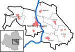
| Location of the city of Nienburg (Saale) in the Salzlandkreis | ||
 _in_SLK.png) |
||

_001.jpg)
Nienburg (Saale) is a town in the Salzlandkreis in Saxony-Anhalt (Germany).
geography
The city is located in the Lower Saale Valley nature park at the confluence of the Bode and Saale rivers .
The districts of Altenburg , Grimschleben and Jesar as well as the villages belong to Nienburg :
| Locality | Residents |
 .svg) (clickable map) |
|---|---|---|
| Gerbitz | 627 | |
| Latdorf | 721 | |
| Neugattersleben | 890 | |
| Pobzig | 400 | |
| Wedlitz | 401 |
history
middle Ages
In view of Nienburg's location on a hill, on two rivers and fertile soils, it can be assumed that Nienburg was settled in prehistoric times. Early historical finds in the urban area and the surrounding area testify to this. Nienburg was mentioned in 961 in one of the founding documents of the Gernrode monastery and at that time belonged to Northern Thuringia . Around 970, the Jewish traveler Ibrahim ibn Jaqub , who came from Moorish Spain, mentions the place Núb Gh.rád : "This castle is made of stone and is also located on the S.láwa river and into which the Búda river falls" .
For several centuries, Nienburg was on the eastern outer border of the Carolingian and German empire . Probably in the 9th century a castle belonging to the Frankish Carolingian empire was built here. Between 930 and 950 the "New Castle" (= Nienburg) was built on the area of the later monastery. The famous historical chronicle of Annalista Saxo was written in the monastery of Nienburg between 1148 and 1152 . On the Ebstorfer world map from the 13th century is Nienbg. at the confluence of Boda Fl. and Sala Fl. drawn.
The location of Nienburg on several trade routes was a major reason for the fortification. From north to south which ran Salzstraße Hall - Magdeburg , from east to west, a central street from the Empire at the Lausitz . Several fords made it possible to cross both rivers. Nienburg was of considerable strategic importance in the eastward expansion of the German Empire into Slavic populated areas.
Early modern age


As a result of the Reformation and the Peasant Wars , the Nienburg Monastery was handed over to the Princes of Anhalt-Köthen in 1563 , who rebuilt the cloister building from 1680 to 1690 to use it as a castle and widow's residence. When Anhalt was divided in 1603, Nienburg fell to the newly founded principality of Anhalt-Köthen. During the Thirty Years War , the city was badly damaged from 1623 onwards, but was soon rebuilt.
In 1715, the previous Princess Gisela Agnes von Anhalt-Köthen withdrew to her widow's residence at Schloss Nienburg, where she resided under the title of "Imperial Countess of Nienburg" until her death in 1740. It was also at her court in Nienburg that Johann Sebastian Bach met her son, Prince Leopold , in 1716 , who signed him to Koethen as Kapellmeister the following year .
As an important port of the Duchy of Anhalt-Köthen and as the main transshipment point of the country surrounded by Prussia, Nienburg regained importance at the beginning of the 19th century. On the waterway via Saale and Elbe, the products of the agrarian-dominated economy of the duchy were exported from here to Hamburg, sometimes even overseas, bypassing the Prussian customs. In addition to grain, this included wool, whose quality was widely praised. Sheep breeding was therefore one of the main sources of income for the duchy.
In 1812 Gustav Flügel was born in Nienburg , who later became famous as a piano composer (sonatas, "moths") and as an organ composer (chorale preludes, concert pieces).
In 1825, the Anhalt-Köthener court building officer Gottfried Bandhauer built a very innovative steel cable-stayed bridge over the Saale, which was opened to traffic on September 6th. The construction of the bridge was controversial in the city, because the ferry traffic across the river could collect fees, as the cable ferry had to lower the ferry cable for every ship passing by, for which fees were charged. There was also the problem that river boats with their sail masts could not pass the bridge so easily.
Deviating from the suspension bridges that are now common in England with their rather large clear widths, Bandhauer devised a new type of bridge, the cable-stayed bridge. The bridge was no longer suspended from a continuous supporting cable, but all segments opposite the two supporting pillars were braced directly and anchored in the rock on the bank. This made it possible for Bandhauer to build a hinged opening in the middle of the bridge. The opening, which was only a few meters wide, could therefore be opened for the masts of the sailing ships for a fee, which the Nienburg citizens welcomed, because they now had a source of income again. In fact, the bridge consisted of two completely independent cable-stayed bridges, which were only connected with a loose and statically insignificant flap.
However, the half facing the city collapsed on December 6th of the same year due to an extreme one-sided overloading of the bridge, which was actually safely constructed according to today's calculations. The resonance catastrophe occurred during a torchlight procession in honor of the head of the country, Duke Ferdinand , for which many citizens had gathered on the bridge. The marching band stopped on the bridge to serenade their princes. Many participants in the procession then went to the side of the bridge facing the castle to see the reaction of their prince. This led to the overloading of the suspension cables (in fact, they were chains) and the world's first cable-stayed bridge partially collapsed. The bridge type, which is so successful today, was destroyed because of an extreme overload that never occurred during normal operation and was never rebuilt in its shape.
A newspaper article reports: "At a celebration in honor of his Highness the Prince of Anhalt Koethen, one side collapsed, with some 80 people, some drowned and some had accidents" . In addition to the dead, over 100 were seriously injured. After all, this catastrophe meant that from this point onwards soldiers were no longer allowed to cross bridges in lockstep .
Remnants of this first German steel bridge were reused by Bandhauer in 1827 in the remarkable classicist sheepfold of Nienburg-Grimschleben, which was also to serve as a model for the sheepfolds of the Anhalt-Koethenian sheep farms in Askania Nova , Ukraine in 1828 .
Modern times

In the course of industrialization after 1850, three shipyards, three cement works (Concordia, Sachsen-Anhalt and Jesarbruch), a sugar factory, a chemical factory and a copper foundry of the Swedish company Hallström were established and established. In 1871 the castle or the former monastery was sold to an industrialist who converted the building into a malt factory . The entrepreneur Hallström built a villa on the market square, which is now used as a retirement home.
In the first half of the 20th century, Nienburg was known as a ship's town, benefiting from its location on the Bode and Saale. A significant proportion of the population found their livelihood in inland shipping .
In the Great Depression in the 1930s, Nienburg experienced a lasting loss of its industrial structure. Basically only the cement works remained. After the reunification in 1990, the works were taken over by the Schwenk company and closed due to the worn out technical systems and the high pollution of the environment. Since then, a lack of economic prospects has led, as in large parts of eastern Germany, to an emigration, especially of the young population.
Incorporations
On July 1, 1950, the previously independent community of Grimschleben was incorporated. On January 1, 2010, Gerbitz , Latdorf , Neugattersleben , Pobzig and Wedlitz were added.
politics
City council
In the 2009 local elections, 16 city councilors were elected. After the incorporation in 2010, the number of council seats has increased to 20. The following table shows the distribution of seats after the 2009 election, as of June 2012 and the distribution of seats after the local election on May 25, 2014 and the local election on May 26, 2019.
| Party / list | Seats 2009 | Seats 2012 | Seats 2014 | Seats 2019 |
| SPD | 3 | 4th | 4th | 3 |
| CDU | 2 | 2 | 4th | 4th |
| left | 3 | 2 | 2 | 2 |
| FDP | 3 | 3 | 2 | 2 |
| UWG of the rural communities | 5 * | 5 | 4th | 4th |
| UWG Nienburg (Saale) | 4th | 3 | 4th | |
| Alliance 90 / The Greens | - | - | - | 1 |
| non-attached | - | - | 1 | - |
| total | 16 | 20th | 20th | 20th |
* The groups of voters are summarized in the country's statistics.
coat of arms
Blazon : "In silver on green grass a red castle with ungezinnter wall on the gate is open, its gable a green lime leaf adorns; on the wall there are six small, unpinned turrets, behind it two large tinned towers with pointed roofs and oriel turrets. “Nienburg's heraldic animal is the lion.
flag
The city of Nienburg (Saale) flies a flag. The colors of the flag are red - silver (white).
Town twinning
- Nienburg / Weser in Lower Saxony
Attractions

Stadtkirche_St.-Johannis.jpg)
- The well-preserved monastery church of St. Marien and St. Cyprian of the Nienburg monastery with components from the 11th century is one of the most important early Gothic buildings in Central Germany. It belongs to the Evangelical Church of Anhalt and is used ecumenically.
- The Jewish cemetery on Adolf-Meyer-Straße was laid out at the beginning of the 19th century. It is a protected cultural monument . Only a small part of the original gravestones that were placed for the Jewish deceased from Nienburg and the surrounding area from the beginning of the 19th century to the 20th century is still on it.
Memorials
- Memorial in the local cemetery in Gatterslebener Strasse for the victims of fascism
tourism
Nienburg is located on well-known holiday routes and long-distance cycle routes : the Romanesque Road , the German Alleenstrasse , the Saale Cycle Route (called Saale-Rad-Wander-Weg), the European Cycle Route R1 and the Blue Ribbon .
Personalities
- Annalista Saxo , Nienburg chronicler
- Gottfried Bandhauer (1790–1837), master builder and designer
- Gustav wing , piano composer
- Gisela Agnes von Rath (1669–1740), Countess of Nienburg, Princess of Anhalt-Köthen
- Ibrahim ibn Jaqub , traveler, first mention of Nienburg
- Friedrich Lutzmann (1859–1930), automobile pioneer
- Ronny Siewert , cooking with a star in the Michelin guide awarded
- Hodo I (around 930–983), buried in the Nienburg monastery on the Saale
- Andreas Ottomar Goelicke (1671–1744), physician and university professor
- Ulrich Gerstner (* 1954), district administrator of the former district of Bernburg and the Salzland district
traffic
The Nienburg (Saale) stop is on the Bernburg – Calbe (Saale) railway line and is served by the RB 48 line. On weekdays the trains run as a direct connection to Magdeburg Hbf via Schönebeck (at times also to Haldensleben and Wolfsburg as RB 36 ), and daily directly to Halle (Saale) Hbf as RB 47 .
The station building had a facade made of yellow clinker bricks. It was demolished in March 2016 after it was vacant and damaged by vandalism.

literature
- Erich Vogel: Chronicle of the Nienburg Monastery, part 2 1004 to 1563 (brochure of the Evangelical Church Congregation St. Johannis and St. Marien and Catholic Church Congregation St. Nicolaus), Nienburg / Saale
- Bernd Nebel: Christian Gottfried Heinrich Bandhauer and the collapse of the Nienburger Saalebrücke , Books on Demand, 2015, ISBN 978-3-7347-1205-0
Web links
Individual evidence
- ↑ State Statistical Office Saxony-Anhalt, population of the municipalities - as of December 31, 2019 (PDF) (update) ( help ).
- ↑ The collapse of the Nienburg inclined chain bridge. In: bernd-nebel.de. Retrieved July 18, 2020 .
- ↑ StBA: Area changes from January 01 to December 31, 2010
- ↑ Disputes agreement due to the dissolution of the administrative community Nienburg (Saale) (PDF; 377 kB)
- ↑ State Statistical Office Saxony-Anhalt and City of Nienburg (Saale)
- ^ Blue ribbon Saxony-Anhalt / Thuringia
- ↑ nienburgsaale.de, information on the station building ( memento of the original from August 1, 2016 in the Internet Archive ) Info: The archive link was inserted automatically and has not yet been checked. Please check the original and archive link according to the instructions and then remove this notice.
Cities: Alsleben (Saale) | Aschersleben | Barby | Bernburg (Saale) | Calbe (Saale) | Leeches | Güsten | Hecklingen | Skills | Nienburg (Saale) | Schönebeck (Elbe) | Zealand | Staßfurt . Municipalities: Bördeaue | Börde-Hakel | Bördeland | Borne | Giersleben | Ilberstedt | Plötzkau | Wolmirsleben .