
Wolmirsleben
| coat of arms | Germany map | |
|---|---|---|

|
Coordinates: 51 ° 57 ' N , 11 ° 29' E |
|
| Basic data | ||
| State : | Saxony-Anhalt | |
| County : | Salzlandkreis | |
| Association municipality : | Egelner Mulde | |
| Height : | 77 m above sea level NHN | |
| Area : | 16.91 km 2 | |
| Residents: | 1310 (Dec. 31, 2019) | |
| Population density : | 77 inhabitants per km 2 | |
| Postal code : | 39435 | |
| Area code : | 039268 | |
| License plate : | SLK, ASL, BBG, SBK, SFT | |
| Community key : | 15 0 89 365 | |
| LOCODE : | DE WOO | |
| Association administration address: | Market 18 39435 Egeln |
|
| Website : | ||
| Mayor : | Knut Kluczka ( CDU ) | |
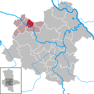
| Location of the community Wolmirsleben in the Salzlandkreis | ||
  |
||

Wolmirsleben is a municipality in the Börde, in the middle of Saxony-Anhalt , directly southwest of Magdeburg . It belongs to the Egelner Mulde association in the Salzland district .

history
The place was first mentioned in 937 as "Wilmersleve". The spot was given away by Otto I to the Moritz monastery in Magdeburg.
In 1227 the Archbishop of Magdeburg transferred Wolmirsleben to the Magdeburg Dompropstei . This sold part of the land to the monasteries Berge and Marienstuhl .
The Thirty Years War 1618-1648 brought hardship and misery, with the population being decimated. In the Treaty of the Peace of Westphalia , the place Brandenburg was added.
In 1817 the road from Wolmirsleben to Atzendorf was built. In 1849 the development of the “Sophie” lignite mine, which was closed in 1925, began. As a result of underground mining, the lakes (Bruchseen) were created in the area.
In 1888 the railway line from Etgersleben to the "Sophie" mine was opened. By 1897 the line was extended to Unseburg. The trains ran on this route until the Second World War .
In 1944 a barrack camp for 300 so - called half - Jews was built. To a second camp for another 300 prisoners and prisoners of war , which mainly in the shaft IV of Neustaßfurt important war forced labor do had, recalls nothing more.
Memorials
- War victims memorial (resting lion) in the community cemetery.
- Graves in the local cemetery for five Poles , unknown by name , who were deported to Germany during the Second World War and were victims of forced labor.
politics
Municipal council
After the 2009 election, the council consists of twelve council members and the mayor.
- CDU 5 seats
- UWG 3 seats
- The left 2 seats
- Dorfgemeinschaftsverein eV 2 seats
After the 2014 election there is this distribution of seats:
- CDU: 6 seats
- DIE LINKE: 3 seats
- without parliamentary group: 3 seats
coat of arms
Blazon : "In green, a pointed silver tower with a knob and black openings."
The municipal council decided in 1991 to include the local water tower in the coat of arms. This was realized by the Magdeburg municipal heraldist Jörg Mantzsch , who also initiated the approval process.
Attractions
- St. Nikolai Church
- Mausoleum of the Schaeper family
- Water tower of the municipality (to be seen in the coat of arms)

Personalities
- Johann Esaias Silberschlag (1721–1791), astronomer and theologian . He was country preacher in Wolmirsleben until 1756. In 1754 he married Katharina Maria Köbke from Magdeburg in Wolmirsleben.
- Diana Körner (* 1944), actress
traffic
Wolmirsleben was on the Etgersleben – Förderstedt railway line . This is shut down.
Web links
Individual evidence
- ↑ State Statistical Office Saxony-Anhalt, population of the municipalities - as of December 31, 2019 (PDF) (update) ( help ).
- ↑ http://www.wolmirsleben.de/gemeinderat/index.htm ( page no longer available , search in web archives ) Info: The link was automatically marked as defective. Please check the link according to the instructions and then remove this notice.
Cities: Alsleben (Saale) | Aschersleben | Barby | Bernburg (Saale) | Calbe (Saale) | Leeches | Güsten | Hecklingen | Skills | Nienburg (Saale) | Schönebeck (Elbe) | Zealand | Staßfurt . Municipalities: Bördeaue | Börde-Hakel | Bördeland | Borne | Giersleben | Ilberstedt | Plötzkau | Wolmirsleben .