
Bitterfeld district
| coat of arms | Germany map |
|---|---|

|

Coordinates: 51 ° 37 ′ N , 12 ° 19 ′ E |
| Basic data (as of 2007) | |
| Existing period: | 1990-2007 |
| State : | Saxony-Anhalt |
| Administrative headquarters : | Bitterfeld |
| Area : | 509.96 km 2 |
| Residents: | 98,285 (Dec. 31, 2006) |
| Population density : | 193 inhabitants per km 2 |
| License plate : | BTF |
| Circle key : | 15 1 54 |
| Circle structure: | 32 municipalities |
| Address of the district administration: |
Mittelstrasse 20 06749 Bitterfeld |
| Website : | |
| District Administrator : | Uwe Schulze ( CDU ) |
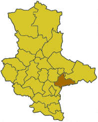
| Location of the district of Bitterfeld in Saxony-Anhalt | |
  |
|

The district of Bitterfeld was a district in the southeast of the state of Saxony-Anhalt. Neighboring districts were the independent city of Dessau in the north, the district of Wittenberg in the northeast, the Saxon district of Delitzsch in the southeast, the Saalkreis in the southwest and the district of Köthen in the west . The district became part of the Anhalt-Bitterfeld district .
Settlement history
Traces of settlement in the area of the district go back to the Neolithic Age. Numerous archaeological finds come from the Fuhneaue and the Düben Heath . In the Dübener Heide a large number of barrows from the time of the Lausitz culture are known. In addition to archaeological finds from the Iron Age , which show both Latène Age (Celtic) and Germanic influences, finds from the 9th century onwards show that the area was settled by Slavic people . Further traces of Slavic settlement can be seen in numerous place names. Noteworthy are Flemish settlers in the Bitterfeld area, which are documented for the 12th century. The Counts of Brehna , in whose county the area of the Bitterfeld district was located , achieved great importance .
Administrative history
The Prussian district of Bitterfeld was established in 1816 when Prussia was awarded part of the Kingdom of Saxony as a result of the Congress of Vienna in 1815. This gave rise to the Prussian province of Saxony to whose administrative district Merseburg the newly created district of Bitterfeld belonged. The district area consisted of the former offices of Bitterfeld , Zörbig , Graefenhainichen , Düben and parts of the offices of Delitzsch and Lauchstädt .
During an exchange of territory between Prussia and Anhalt on April 1, 1942, the Prussian exclave locations Möst bei Schierau , Pösigk , Priorau , Repau and Schierau with the border town Goltewitz were assigned to the Anhalt district of Dessau-Köthen . In return, the Anhalt border town of Wadendorf became part of the Prussian district of Bitterfeld.
Larger territorial changes only occurred after more than 130 years with the "Law to Change District and Municipal Boundaries" of June 9, 1950. As a result, some of the towns and communities formerly belonging to the Duchy of Anhalt (e.g. Raguhn and Jeßnitz ) came to the Bitterfeld district. In the west of the district, the communities Drehlitz, Drobitz, Köseln, Kütten, Mösthinsdorf, Ostrau, Plötz and Werderthau fell to the Saalkreis . In the south, the municipality of Döbern came from the Delitzsch district to the Bitterfeld district.
The GDR administrative reform of 1952 with the "Law on the Further Democratization of the Structure and Functioning of State Bodies in the Lands of the GDR" of July 23, 1952 brought not only the creation of the districts, but also extensive territorial changes at district level. The city of Düben and the surrounding villages became part of the Eilenburg district in the Leipzig district . At the same time, eastern areas of the district were assigned to the newly created Graefenhainichen district . The Bitterfeld district now belonged to the Halle district .
District administrators
- Hans von Bodenhausen (1881–1899)
Traffic history
The district of Bitterfeld was connected to a regular network of roads in 1823 with a connection to the Chaussee from Berlin via Halle (Saale) to Kassel . Its course corresponds to today's federal highway 100 in the district area . The Magdeburg - Halle (Saale) line, opened in 1840 by the Magdeburg-Leipzig Railway Company , connected the Bitterfeld district to the still young German railway network. However, it was of little use as the line only touched the western part of the circle. The situation improved when Bitterfeld received a rail connection to Dessau in 1857 and was connected to the network of the Berlin-Anhalt Railway . Connections to Leipzig , Halle (Saale) and Wittenberg were established just two years later . Bitterfeld thus became a railway junction in 1859 and offered an excellent starting point for the development of the local lignite and stoneware industry. The railway network was supplemented in 1897 with the Bitterfeld - Stumsdorf line , which connected the Bitterfeld railway junction directly with the Magdeburg - Halle (Saale) line. In 1868 the Kreischaussee Bitterfeld - Zörbig was opened. The Bitterfeld - Düben rail project , which was hotly debated around the turn of the century, never came to fruition. In contrast, the Bitterfeld district was able to refer to electric train traffic in 1911. The first standard-gauge full-gauge railway line in the German Empire went into operation. The railway line was fed with energy from the nearby Reichsbahnkraftwerk Muldenstein . With the beginning of the First World War , the electrical operation was stopped and only resumed in 1922/1923. Bitterfeld was now part of the Central German Ring, which ran from Magdeburg via Dessau to Halle (Saale) and Leipzig. The Reichsautobahn from Berlin to Nuremberg (today's BAB 9) touched the district and was opened in 1936. There were three ascents and descents in a circle: Dessau-Süd, Zörbig (today exit Wolfen) and Brehna .
County coat of arms
Blazon : “Quartered. Field 1 and 4: three red sea leaves in silver; Field 2: a black, red-armored lion in gold; Field 3: two blue posts in gold. "
cities and communes
(Resident on December 31, 2006)
- Sandersdorf (9,552)
- Zörbig , City (9,597)
Administrative communities with their member communities
| Headquarters of the administrative association * | |
|
|
License Plate
At the beginning of 1991 the district received the distinguishing mark BTF . It was issued through June 30, 2007. It has been available in the Anhalt-Bitterfeld district since November 27, 2012.
literature
- Mathias Tullner: The Bitterfeld district and its administration 1816–1952. In: Bitterfelder Heimatblätter, special issue 1999 . Self-published, pp. 1–134, ISSN 0232-8585
Web links
Individual evidence

Cities : Dessau | Halle (Saale) | Magdeburg
Districts : Altmarkkreis Salzwedel | Anhalt-Zerbst district | Aschersleben-Staßfurt district | District of Bernburg | District of Bitterfeld | Bördekreis | Burgenland District | District of Halberstadt | District of Jerichower Land | District of Köthen | District of Mansfelder Land | District of Merseburg-Querfurt | Circle of ears | District of Quedlinburg | Hall circle | District of Sangerhausen | District of Schönebeck | District of Stendal | Weissenfels District | District of Wernigerode | Wittenberg district