
Bitterfeld district
| Basic data | |
|---|---|
| District of the GDR | Hall |
| County seat | Bitterfeld |
| surface | 454 km² (1989) |
| Residents | 126,181 (1989) |
| Population density | 278 inhabitants / km² (1989) |
| License Plate | K and V (1953–1990) KD, KE, VD and VE (1974–1990) |
  |
|
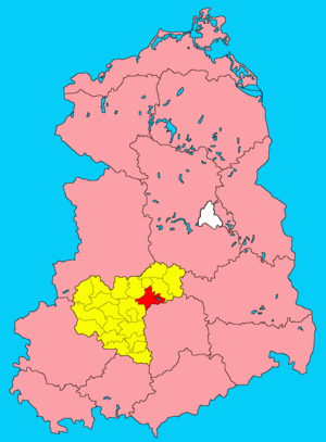
| The Bitterfeld district in the Halle district (clickable map) |
|
The Bitterfeld district was a district in the Halle district of the GDR . From 1990 to 1994 it continued as the Bitterfeld district in the state of Saxony-Anhalt . His area is now in the Anhalt-Bitterfeld district in Saxony-Anhalt. The seat of the district administration was in Bitterfeld .
geography
location
The district of Bitterfeld was north of Leipzig on both sides of the Mulde .
Neighboring areas
The district of Bitterfeld bordered clockwise in the north, beginning with the urban district of Dessau and the districts of Graefenhainichen , Eilenburg and Delitzsch ( district of Leipzig ), Saalkreis and Köthen .
history
A district of Bitterfeld had existed in the Prussian province of Saxony since 1815 , which had belonged to the state of Saxony-Anhalt since 1945 and thus to the GDR since 1949. On July 25, 1952, there was a comprehensive district reform in the GDR , in which, among other things, the states were dissolved and replaced by districts . The district of Bitterfeld gave larger parts of the area to the new districts of Graefenhainichen and Eilenburg . The Bitterfeld district was formed from the remaining part of the district together with some communities from the old Köthen district. This was assigned to the newly formed Halle district .
6 cities and 42 communities belonged to the district of Bitterfeld:
|
On May 17, 1990, the district was renamed the Bitterfeld district. Since the reunification of the two German states in October 1990, the district has belonged to the re-established state of Saxony-Anhalt . During the second district reform in Saxony-Anhalt , it went on July 1, 2007 in what is now the Anhalt-Bitterfeld district.
Population development
| Bitterfeld district | ||||||||
|---|---|---|---|---|---|---|---|---|
| year | 1960 | 1971 | 1981 | 1989 | ||||
| Residents | 140.720 | 138,761 | 129,911 | 126.181 | ||||
economy
The most important branches of industry in the Bitterfeld district were lignite mining with the Muldenstein and Goitzsche opencast mines and the chemical industry. Significant companies were among others:
- VEB Chemical Combine Bitterfeld
- VEB industrial and power plant pipeline construction Bitterfeld
- VEB Fotochemisches Kombinat Wolfen
- VEB plastic and textile processing plant Pouch
traffic
The district was connected to the GDR motorway network through the Berlin Ring – Hirschberg motorway with the Bitterfeld and Halle junctions. The national road traffic also served the long-distance roads F 100 towards Halle and Wittenberg , the F 183 towards Köthen and Bad Düben and the F 184 towards Dessau and Leipzig .
In the Bitterfeld station , the main railway lines Berlin – Halle crossed with the stations Burgkemnitz, Muldenstein, Roitzsch and Brehna and Dessau – Leipzig with the stations Marke, Raguhn, Jeßnitz, Wolfen, Greppin and Petersroda. There was also a branch line from Bitterfeld via Zörbig to Stumsdorf , which connected the district with the Magdeburg – Halle – Leipzig line .
License Plate
After 1952, the vehicles registered in the district were given license plates beginning with the letter K (as in the entire GDR district of Halle). License plates with the initial letter V were added later. Motor vehicles (with the exception of motorcycles) and trailers were assigned three-letter distinctive signs from around 1974 to the end of 1990, beginning with the letter pairs KD , KE , VD and VE . The last number plate series used for motorcycles was VG 50-01 to VG 99-99 .
At the beginning of 1991 the district received the distinguishing mark BTF .
Individual evidence
- ↑ a b Statistical Yearbooks of the German Democratic Republic. In: DigiZeitschriften. Retrieved October 6, 2009 .
- ↑ Federal Statistical Office (Ed.): Municipalities 1994 and their changes since 01.01.1948 in the new federal states . Metzler-Poeschel, Stuttgart 1995, ISBN 3-8246-0321-7 .
- ↑ Directory of the municipalities and districts of the German Democratic Republic, Staatsverlag, Berlin 1968, pp. 37–38
- ↑ Law on the self-administration of municipalities and districts in the GDR (municipal constitution) of May 17, 1990
- ↑ StBA Area: changes from 01.01. until December 31, 2007
- ↑ Andreas Herzfeld: The history of the German license plate . 4th edition. German Flag Society V., Berlin 2010, ISBN 978-3-935131-11-7 , pp. 302 f .
- ↑ Andreas Herzfeld: The history of the German license plate . 4th edition. German Flag Society V., Berlin 2010, ISBN 978-3-935131-11-7 , pp. 519 .