
Hohenmölsen district
| Basic data | |
|---|---|
| District of the GDR | Hall |
| District coat of arms | |
| County seat | Hohenmölsen |
| surface | 178 km² (1989) |
| Residents | 27,700 (1989) |
| Population density | 156 inhabitants / km² (1989) |
| License Plate | K and V (1953–1990) KM and VM (1974–1990) HHM (1991–1994) |
  |
|
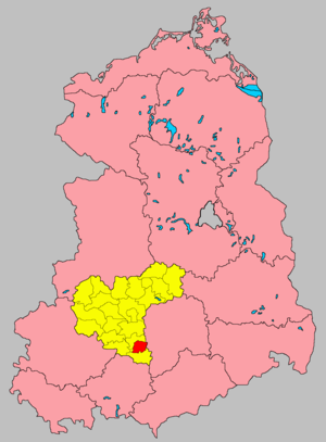
| The Hohenmölsen district in the Halle district (clickable map) |
|
The Hohenmölsen district was a district in the Halle district of the GDR . From 1990 to 1994 it existed as the Hohenmölsen district in Saxony-Anhalt . His area is now in the Burgenland district in Saxony-Anhalt. The seat of the district administration was in Hohenmölsen .
geography
The district of Hohenmölsen bordered clockwise in the north, beginning with the districts of Weißenfels , Leipzig-Land , Borna , Zeitz and Naumburg .
history
On July 25, 1952, a comprehensive district reform took place in the GDR , in which, among other things, the states lost their importance and new districts were formed. The new Hohenmölsen district was formed from parts of the former Weißenfels and Zeitz districts and assigned to the newly formed Halle district .
On May 17, 1990, the district was renamed the Hohenmölsen district. On the occasion of the reunification of the two German states, the district was awarded to the re-established state of Saxony-Anhalt in October 1990 . During the first district reform in Saxony-Anhalt , it was absorbed on July 1, 1994 in the Burgenland district and the Weißenfels district .
Population development
| Hohenmölsen district | ||||||||
|---|---|---|---|---|---|---|---|---|
| year | 1960 | 1971 | 1981 | 1989 | ||||
| Residents | 41,073 | 35,233 | 29,872 | 27,700 | ||||
cities and communes
In 1956 the following towns and municipalities belonged to the Hohenmölsen district:
economy
Lignite mining, especially through the large Profen open-cast mine, played a major role in the Hohenmölsen district. Important companies in the district were next to it
- VEB brown coal works 'Erich Weinert' Deuben
- VEB Paraffinwerk "Vorwärts" Webau
traffic
The district was connected to the GDR motorway network through the Berlin Ring – Hirschberg motorway. The F 91 in the direction of Zeitz and Halle also served national road traffic .
The Hohenmölsen district was opened up by the Groß Korbetha – Hohenmölsen – Deuben , Weißenfels – Teuchern – Zeitz and Teuchern – Naumburg railway lines.
License Plate
Motor vehicles (with the exception of motorcycles) and trailers were assigned three-letter distinguishing signs starting with the letter pairs KM and VM from around 1974 to the end of 1990 . The last number plate series used for motorcycles was VO 50-01 to VO 99-99 .
At the beginning of 1991 the district received the distinctive sign HHM . It was issued until June 30, 1994. Due to the license plate liberalization , it has been available in the Burgenland district since November 27, 2012 .
Individual evidence
- ↑ a b Statistical Yearbooks of the German Democratic Republic. In: DigiZeitschriften. Retrieved October 6, 2009 .
- ↑ a b Federal Statistical Office (ed.): Municipalities 1994 and their changes since 01.01.1948 in the new federal states . Metzler-Poeschel, Stuttgart 1995, ISBN 3-8246-0321-7 .
- ↑ Law on the self-administration of municipalities and districts in the GDR (municipal constitution) of May 17, 1990
- ↑ Law on the further democratization of the structure and functioning of the state organs in the state of Saxony-Anhalt of July 25, 1952
- ↑ Andreas Herzfeld: The history of the German license plate . 4th edition. German Flag Society V., Berlin 2010, ISBN 978-3-935131-11-7 , pp. 302 f .
- ↑ Andreas Herzfeld: The history of the German license plate . 4th edition. German Flag Society V., Berlin 2010, ISBN 978-3-935131-11-7 , pp. 520 .