
Bördekreis
| coat of arms | Germany map |
|---|---|

|

Coordinates: 52 ° 2 ′ N , 11 ° 14 ′ E |
| Basic data (as of 2007) | |
| Existing period: | 1994-2007 |
| State : | Saxony-Anhalt |
| Administrative headquarters : | Oschersleben (Bode) |
| Area : | 872.44 km 2 |
| Residents: | 74,395 (Dec. 31, 2006) |
| Population density : | 85 inhabitants per km 2 |
| License plate : | BÖ |
| Circle key : | 15 3 55 |
| Circle structure: | 36 municipalities |
| Address of the district administration: |
Triftstrasse 9-10 39387 Oschersleben |
| District Administrator : | Burkhard Kanngießer ( SPD ) |
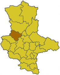
| Location of the Bördekreis in Saxony-Anhalt | |
  |
|
The Bördekreis was a district in the west of the state of Saxony-Anhalt. On July 1, 2007, it was merged with the Ohrekreis to form the new Börde district as part of the district reform in Saxony-Anhalt .
Neighboring districts were the Ohrekreis in the north, the independent city of Magdeburg in the northeast, the Schönebeck district in the east, the Aschersleben-Staßfurt , Quedlinburg and Halberstadt districts in the south and the Helmstedt district in the west .
geography
The area of the Bördekreis extended from the central part of the Magdeburger Börde in the east over the Bode, which stretches out in a wide arc to the north, to the upper Aller and the foothills of the Lappwald ridge in the northwest.
traffic
The Braunschweig – Magdeburg and Magdeburg – Oschersleben – Halberstadt railway lines ran through the Bördekreis .
history
The district was created in 1994 by amalgamating the districts of Oschersleben and Wanzleben, including the city of Kroppenstedt , which had previously been part of the Staßfurt district. On April 1, 2001, the district area was reduced by the incorporation of the municipality of Beyendorf into neighboring Magdeburg. On July 1, 2007, the Bördekreis was merged with the previous Ohrekreis in the new Börde district . The first district administrator of the Börde district was Thomas Webel (CDU).
coat of arms
Blazon : "Quartered by 1: 4 silver, 2: 3 red, covered with a blue sloping bar, a golden ear at the top, a golden upright scythe leaf at the bottom front."
Approved October 14, 1994 by the Minister of the Interior.
The Magdeburger Börde gives the district Bördekreis its name. The golden ear and the golden scythe leaf stand for their fertility, the priority of agriculture and the resulting industry. The blue diagonal wave bar symbolizes the lowlands of the Great Break , Bode and floodplain landscapes.
cities and communes
(Resident on December 31, 2006)
- Sülzetal (9,814)
Administrative communities with their member communities
* Seat of the administrative community
|
|
|
|
Territorial changes
Since 1995 there have been many changes of area in the Bördekreis.
From the original 9 administrative communities there were still 4 administrative communities when the district was dissolved. During the same period, the number of parishes remained the same.
Changes in administrative communities
- Dissolution of the Sülzetal administrative community - formation of the Sülzetal single community from the member communities without Beyendorf, incorporation of Beyendorf to Magdeburg (April 1, 2001)
- Dissolution of the administrative community Bodeaue - incorporation of the member communities into the administrative community Oschersleben (Bode) (July 1, 2002)
- Incorporation of the municipality of Ampfurth from the administrative community "Börde" Seehausen / Klein Wanzleben into the city of Oschersleben (Bode) in the VG Oschersleben (Bode) (January 18, 2003)
- Formation of the administrative community "Börde" Wanzleben from the administrative communities "Börde" Seehausen / Klein Wanzleben (without the municipality of Schermcke ) and Sarretal-Wanzleben (January 1, 2004)
- Integration of the community of Schermcke from the VG "Börde" Seehausen / Klein Wanzleben into the VG Oschersleben (Bode)
- Formation of the administrative community Westliche Börde from the administrative communities Gröningen and Hamersleben (January 1, 2005)
- Formation of the administrative community Obere Aller from the administrative communities Allerquelle , Hötensleber Winkel and Ost-Lappwald as well as the administrative community-free municipality Wefensleben (January 1, 2005)
License Plate
On July 1, 1994, the district was assigned the OC distinguishing mark introduced on January 1, 1991 for the Oschersleben district. On March 22, 1996 the identifier was changed to BÖ . It was issued in the Börde district until September 30, 2007. Due to the license plate liberalization, it has been available there again since November 27, 2012; wherein further letter combinations are possible.
Until around the year 2000, vehicles from the old Wanzleben district had license plates with the letter pairs AA to ZZ and the numbers from 1 to 99.
Web links
Individual evidence
- ↑ http://www.stala.sachsen-anhalt.de/wahlen/kw04/erg/kreis/kw.15355.ergtab.frame.html , accessed on December 2, 2012

Cities : Dessau | Halle (Saale) | Magdeburg
Districts : Altmarkkreis Salzwedel | Anhalt-Zerbst district | Aschersleben-Staßfurt district | District of Bernburg | District of Bitterfeld | Bördekreis | Burgenland District | District of Halberstadt | District of Jerichower Land | District of Köthen | District of Mansfelder Land | District of Merseburg-Querfurt | Circle of ears | District of Quedlinburg | Hall circle | District of Sangerhausen | District of Schönebeck | District of Stendal | Weissenfels District | District of Wernigerode | Wittenberg district