Kroppenstedt
| coat of arms | Germany map | |
|---|---|---|

|
Coordinates: 51 ° 56 ' N , 11 ° 19' E |
|
| Basic data | ||
| State : | Saxony-Anhalt | |
| County : | Börde | |
| Association municipality : | Western Börde | |
| Height : | 97 m above sea level NHN | |
| Area : | 38.65 km 2 | |
| Residents: | 1414 (Dec. 31, 2019) | |
| Population density : | 37 inhabitants per km 2 | |
| Postal code : | 39397 | |
| Area code : | 039264 | |
| License plate : | BK , BÖ, HDL, OC, OK, WMS, WZL | |
| Community key : | 15 0 83 355 | |
| LOCODE : | DE KPT | |
| NUTS : | DEE07 | |
City administration address : |
Marktstrasse 7 39397 Gröningen |
|
| Website : | ||
| Mayor : | Joachim Willamowski (non-party) | |
| Location of the city of Kroppenstedt in the Börde district | ||
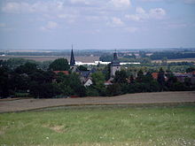
Kroppenstedt is a town in the Börde district in Saxony-Anhalt . It is a member community of the Western Börde Association .
geography
The small town in the Magdeburg Börde lies between the state capital Magdeburg and the Harz Mountains . The closest cities are Oschersleben (Bode) 15 km northwest, Halberstadt 20 km west and Quedlinburg 24 km south. It is nicknamed Reithufenstadt.
history
Kroppenstedt was mentioned for the first time on May 25, 934 in a document with which King Heinrich I gave Count Siegfried in Schwabengau his possessions in Gröningen , Kroppenstedt and Ammendorf. After Siegfried's death, power over these areas went to the Corvey Monastery in Höxter , on the condition that a branch monastery would be established in West Gröningen. Parts of it later became the property of the Halberstadt diocese . Kroppenstedt received city rights in 1253.
In the vicinity of Kroppenstedt there are four desert areas: Nienstedt in the north, Ammendorf in the east, Wentlingen in the northwest and the later repopulated Dalldorf in the southwest.
Population development since 1990
| date | 3rd October 1990 | 1995 | 2000 | 2001 | 2002 | 2003 | 2004 | 2005 | 2006 |
| Residents | 1831 | 1788 | 1769 | 1751 | 1735 | 1708 | 1657 | 1624 | 1624 |
1995–2006: cut-off date on December 31 of each year
politics
City council
After the local elections on May 25, 2014, the local council was composed as follows:
| Party / list | Seats |
|---|---|
| CDU | 6th |
| SPD | 1 |
| FDP | 2 |
| Individual applicants | 3 |
coat of arms
The coat of arms was approved on August 10, 1995 by the Magdeburg Regional Council.
Blazon : "In blue on a silver, red-bridled and saddled horse, Saint Martin (Saint Martin) in a golden robe, sharing his red cloak with the silver sword for the beggar kneeling in front of him."
The coat of arms of Kroppenstedt comes from a seal documented for the year 1359 with the inscription “S. OPIDI IN CROPPENSTEDE ”. Saint Martin as a symbol was the patron saint of the Kroppenstedt town church. As was the case with numerous cities and municipalities, Christian motifs were originally used in the seal and later transferred to a coat of arms - even without state legitimation being given for this.
The redesign of the coat of arms was done by the local heraldist Jörg Mantzsch .
Infrastructure
At present the federal road 81 (Magdeburg – Halberstadt) still runs through Kroppenstedt, as does the state road 66. From September 4, 2007, the Kroppenstedt bypass of the B 81 was built. The Kroppenstedt bypass was symbolically opened to traffic as part of the B 81 on November 18, 2008 at 3:30 p.m. The rerouting of road traffic to the newly built bypass did not take place until the light came on on November 19, as risks were to be feared as a result of a sudden change in traffic management when it got dark. The link between the B 81 new and the B 81 old at the Kroppenstedt-Ost junction was then established by December 18, 2008.
Culture and sights
Museums
The town's local history museum is now located in the former boys' school from the 15th century.
Multi-generation house
The multi-generation house (MGH) is a meeting place for old and young. It's on the gymnastics field.
Memorials
- Memorial stone in the local cemetery for the three local victims of fascism Max Kasperschinsky, Wilhelm Firse and Julius Freiberg, as well as eleven concentration camp prisoners on a death march from Buchenwald concentration camp , who were murdered by SS men in April 1945
- Memorial stone on the former Jewish cemetery on the Anger, which commemorates the Jewish victims of the Shoah .
Buildings
Particularly noteworthy are:
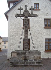
- The Freikreuz , a baroque sandstone cross, which is unique in this form as a symbol of urban freedom and a place of direction.
- The Saint Martin Church , which combines the styles Romanesque ( tower ), Gothic ( nave ), Renaissance ( nave ) and Baroque ( altar ). It is also equipped with an organ built by Esaias Compenius .
- The old school , a 15th century building that now serves as a local museum .
- The Kroppenstedter Town Hall , the oldest parts of which date from the 16th century .
- The city fortifications from the 13th century with the Owl Tower , one of three former city gate towers and the partially very well-preserved double wall with a total of 4 defense towers.
The city's cultural monuments are listed in the local register of monuments.
Regular events
Every year on October 3rd the Freikreuzfest takes place. It is a folk festival with a medieval market and historical amateur play.
Personalities
In Kroppenstedt were born:
- Ludolf von Kroppenstedt , Archbishop of Magdeburg from 1192 to 1205
- Johannes Scharff (1595–1660), Lutheran theologian and philosopher
- Andreas Gravenhorst (1684–1727), Protestant theologian and schoolboy
- Georg (Jürgen) Ackermann, (mid-17th century), contemporary witness of the cremation of Magdeburg and judge and mayor v. Kroppenstedt
- Johann Friedrich Dammas (1772–1850), cantor, music and singing teacher
- Georg Müller (1805–1898), orphanage director
- Gustav Könnecke (1845–1920), archivist and literary historian
The natural scientist Eduard Nehse (1793–?) Ran the Schumann's inn in Kroppenstedt for a time.
traffic
Kroppenstedt had a train station on the disused Aschersleben – Nienhagen line .
Web links
Individual evidence
- ↑ State Statistical Office Saxony-Anhalt, population of the municipalities - as of December 31, 2019 (PDF) (update) ( help ).
- ^ Rudolf Ammann: Chronicle of the city of Kroppenstedt; 1958; "Friendship" printer in Halberstadt
- ↑ Archived copy ( memento of the original from October 31, 2014 in the Internet Archive ) Info: The archive link was inserted automatically and has not yet been checked. Please check the original and archive link according to the instructions and then remove this notice. The State Returning Officer of Saxony-Anhalt, 2014 municipal council elections, Kroppenstedt, final result


