Volpke
| coat of arms | Germany map | |
|---|---|---|

|
Coordinates: 52 ° 8 ' N , 11 ° 6' E |
|
| Basic data | ||
| State : | Saxony-Anhalt | |
| County : | Börde | |
| Association municipality : | Upper all | |
| Height : | 149 m above sea level NHN | |
| Area : | 17.22 km 2 | |
| Residents: | 1248 (Dec. 31, 2019) | |
| Population density : | 72 inhabitants per km 2 | |
| Postal code : | 39393 | |
| Area code : | 039402 | |
| License plate : | BK , BÖ, HDL, OC, OK, WMS, WZL | |
| Community key : | 15 0 83 515 | |
| LOCODE : | DE VPK | |
| NUTS : | DEE07 | |
| Association administration address: | Zimmermannplatz 2 39365 Eilsleben |
|
| Website : | ||
| Mayor : | Wolfgang Smolin | |
| Location of the municipality of Völpke in the district of Börde | ||
Völpke is a municipality in the northwest of the Börde district in Saxony-Anhalt (Germany). It belongs to the community of Obere Aller , which has its seat in the community of Eilsleben .
geography
location
The municipality of Völpke is located in the area of the southern foothills of the Lappwald ridge , not far from the state border with Lower Saxony . It is located 9 km east of Helmstedt and 13 km southeast of Schöningen . The surrounding area between Aller , Lappwald and Elm is hilly and has heights of up to 200 m above sea level. NN ("Wendorfer Berg" 199 m, "Hochberg" 200 m above sea level).
Community structure
The Badeleben district, 1 km to the northeast, belongs to Völpke .
history
Völpke had a long mining tradition. Substantial deposits of brown coal lie in some cases under the agriculturally excellent Bördeboden. Since the beginning of the 19th century, lignite was mined underground in the Helmstedt mining area , and industrial production began after 1847. In 1872, a railway connection to Eilsleben was put into operation, which made it possible to transport the coal. With the industrial boom, the population in the Völpke / Harbke area rose rapidly. The briquette factory was founded in 1898 and the wax factory was built a little later.
On July 1, 1950, the previously independent community of Badeleben was incorporated.
The lignite industry in the district went out after the reunification of Germany: the “Wulfersdorf” opencast mine was closed in 1989, and in 1991 the power station in neighboring Harbke also closed . Finally, in 1992, production at the Völpker briquette factory was also discontinued. The massive job cuts presented the community with major problems. In addition to a few commercial settlements in new commercial and industrial areas, the traditional “Völpker Montanwachs GmbH” (today: Völpker Spezialprodukte GmbH → change of name in 2008), which today employs around 100 people, was retained.
In 1995 the municipality of Völpke acquired the "Nessauischer Hof" mentioned in 1570 - the last four-sided courtyard in Völpke - and converted it into a craftsman's farm.
Short term nationally known Völpke was the DFB Cup game of TSV Völpke against Bayern Munich in 2004, which the Völpker with 0: 6. Back then the venue was the stadium in Dessau.
Population development
|
(Sources: State Statistical Office Saxony-Anhalt)
politics
mayor
On November 10, 2019, Kai Bögelsack was elected mayor of the community.
coat of arms
The coat of arms was approved on October 15, 1993 by the Magdeburg Regional Council.
Blazon : "Divided from red to green by a slanting silver wave bar, a silver mountain iron above and a silver swan below."
The coat of arms was designed by the Heraldic Society "Black Lion" Leipzig.
The flag is striped white and green and has the municipality's coat of arms in the center.
Transport links
The federal road 245 ( Haldensleben - Halberstadt ) runs through Völpke, there are further road connections to the surrounding towns of Helmstedt and Schöningen . The Alleringsleben motorway junction ( A 2 ) is approx. 10 km from the community. The nearest train stations are in Eilsleben , Marienborn and Helmstedt ( Magdeburg – Braunschweig line ).
Buildings
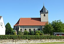
The Evangelical Lutheran Church of St. Margarethen is named after Margaret of Antioch . It was built from 1786 to 1788 after its dilapidated predecessor church was demolished in 1785. Your parish belongs to the parish Hötensleben in the parish of Egeln.
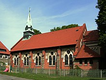
The Catholic Herz-Jesu-Kirche is located on Rudolf-Breitscheid-Straße; it was built in 1905 in the neo-Gothic style. Today the church belongs to the parish of St. Marien , based in Oschersleben.
The cultural monuments in the municipality are entered in the local monument register.
Sons and daughters of the church
- Johanna Boy (* 1851-after 1889), writer
Individual evidence
- ↑ State Statistical Office Saxony-Anhalt, population of the municipalities - as of December 31, 2019 (PDF) (update) ( help ).
- ↑ Land Returning Officer: Mayor elections on 24.02.2013 in the municipality Völpke. State Statistical Office Saxony-Anhalt, March 14, 2013, accessed on May 21, 2013 .
- ↑ http://www.kirchspiel-hoetensleben.de/html/voel/voelpkehome.htm Internet presence of the Protestant parish


