
Verbandsgemeinde Obere Aller
| coat of arms | Germany map | |
|---|---|---|

|
Coordinates: 52 ° 9 ' N , 11 ° 13' E |
|
| Basic data | ||
| Existing period: | 2010– | |
| State : | Saxony-Anhalt | |
| County : | Börde | |
| Area : | 210.16 km 2 | |
| Residents: | 14,367 (Dec. 31, 2019) | |
| Population density : | 68 inhabitants per km 2 | |
| License plate : | BK , BÖ, HDL, OC, OK, WMS, WZL | |
| Association key : | 15 0 83 5053 | |
| Association structure: | 7 municipalities | |
| Association administration address : |
Zimmermannplatz 2 39365 Eilsleben |
|
| Website : | ||
| Mayor of the Association: | Frank Frenkel | |
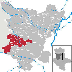
| Location of the municipality of Obere Aller in the Börde district | ||
  |
||

The Verbandsgemeinde Obere Aller is a regional authority in the Börde district in Saxony-Anhalt .
geography
The association is located on the Aller and south of the federal highway 2 .
Member municipalities
The Verbandsgemeinde Obere Aller has the following seven member communities:
history
The association was founded on January 1, 2010, and the Obere Aller administrative community was thus dissolved. Since association communities may have a maximum of eight member communities with at least 1,000 inhabitants each, the following associations took place on the same day:
- Incorporation of the municipalities of Barneberg (734 inhabitants) and Wackersleben (707 inhabitants) into the municipality of Hötensleben , whose population increased from 2,554 to 3,995
- Incorporation of the community of Marienborn (504 inhabitants) into the community of Sommersdorf, whose population increased from 1,030 to 1,534
- Incorporation of the municipality of Wormsdorf (529 inhabitants) into the municipality of Eilsleben , whose population increased from 2,180 to 2,709
On September 1, 2010 the municipalities of Drackenstedt , Druxberge and Ovelgünne were incorporated into the municipality of Eilsleben by law.
The given population figures refer to the key date December 31, 2008.
politics
coat of arms
The coat of arms was approved by the district on October 19, 2010.
Blazon : "A blue flank with a blue wavy bar set in the manner of a flank bar, above the wavy bar in silver blue mallets and iron below with black grout lines in gold, the flank covered with a golden ear with two stalk leaves."
The coat of arms was designed by the Magdeburg heraldist Jörg Mantzsch .
flag
The flag is blue and white (1: 1) striped (horizontal shape: stripes running horizontally, lengthways shape: stripes running vertically) and centered with the municipality's coat of arms.
traffic
The federal highways 245 , 245a and 246a run through the community area . There are also train stations on the Braunschweig – Magdeburg line in Marienborn, Wefensleben, Eilsleben, Ovelgünne and Drackenstedt. In Völpke there was a train station on the Eilsleben – Schöningen railway line, which is no longer in use .
Individual evidence
- ↑ State Statistical Office Saxony-Anhalt, population of the municipalities - as of December 31, 2019 (PDF) (update) ( help ).
- ↑ a b Official Journal of the District No. 80/2010 (PDF; 802 kB)