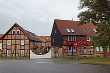
Beendorf
| coat of arms | Germany map | |
|---|---|---|

|
Coordinates: 52 ° 15 ' N , 11 ° 5' E |
|
| Basic data | ||
| State : | Saxony-Anhalt | |
| County : | Börde | |
| Association municipality : | Flechtingen | |
| Height : | 130 m above sea level NHN | |
| Area : | 6.83 km 2 | |
| Residents: | 892 (Dec. 31, 2019) | |
| Population density : | 131 inhabitants per km 2 | |
| Postal code : | 39343 | |
| Area code : | 039050 | |
| License plate : | BK , BÖ, HDL, OC, OK, WMS, WZL | |
| Community key : | 15 0 83 060 | |
| Association administration address: | Lindenplatz 13/15 39345 Flechtingen |
|
| Website : | ||
| Mayor : | Hagen Friedrichs | |
| Location of the municipality of Beendorf in the Börde district | ||
Beendorf is a municipality in the Börde district in Saxony-Anhalt . The community belongs to the Verbandsgemeinde Flechtingen .
geography
Beendorf is located approx. 7 km east of Helmstedt directly on the border with Lower Saxony in the Allertal-Harbke nature reserve on the edge of the Lappwald forest .
politics
Municipal council
In the last local election on May 26, 2019, the turnout was 47.5%. The electoral groups achieved 10 seats and thus 100% of the distribution of seats. Another member of the council and its chairman is the mayor.
coat of arms
The coat of arms was approved on April 1, 1997 by the Magdeburg Regional Council.
Blazon : "In green a silver miner's toughness, in the silver head of the shield three rising green linden leaves in bars." The community chose the silver mallet and iron as a symbol of the former salt mining ; the green linden leaves in the shield head represent the wooded surroundings of Beendorf. The community colors are therefore silver (white) - green. The coat of arms was designed by the Magdeburg heraldist Erika Fiedler .
flag
White and green stripe flag with applied coat of arms of the municipality.
Partner municipality
Beendorf's partner municipality is the Corsican Santa-Maria-Poggio (Santa Maria di u Poghju).
history
From 1994 to January 1, 2005 Beendorf belonged to the administrative community Weferlingen , from 2005 to December 31, 2009 to the administrative community Flechtingen . Since January 1, 2010, Beendorf has been a member of the Flechtingen Association, which was newly founded on that day.
Culture and sights
see the list of cultural monuments in Beendorf
- Permanent exhibition in the Bernhard Becker primary school on the history of the Beendorf satellite camp
- Community grave and memorial stone of 1958 on the local cemetery for 250 concentration camp prisoners who are victims of forced labor were
- Memorial from 1958 in the center of the village for the victims of fascism
- Memorial stone for German reunification at the western entrance to Beendorf
- former potash mine Schacht Marie
Economy and Infrastructure
traffic
To the federal road 1 , which connects Braunschweig with Berlin , it is approx. 2 km southwards. The federal motorway 2 (junction Alleringersleben ) is reached after 5 km.
In Beendorf there is a grocery store with goods for daily needs. Also on site are: kindergarten, elementary school, hairdressers, savings bank, general practitioners, dentist, carpentry and a country inn.


