Lappwald
| Lappwald | |
|---|---|
| Highest peak | nameless hilltop? ( 194 m above sea level ) |
| location | Districts of Helmstedt and Börde ; Lower Saxony and Saxony-Anhalt ( Germany ) |
| Coordinates | 52 ° 15 ′ N , 11 ° 2 ′ E |


The Lappwald is a maximum of about 194 m above sea level. NHN high, 17 km long and up to 5 km wide, wooded ridge of the Weser-Aller lowlands . It is located near Helmstedt in the border area between Lower Saxony ( Helmstedt district ) and Saxony-Anhalt ( Börde district ), with around three quarters belonging to Lower Saxony area.
geography
location
The Lappwald lies east to north of Helmstedt (Lower Saxony) and west of Walbeck (Saxony-Anhalt). It extends in north-north-west-south-south-east direction parallel to the Elm, which is almost 20 km west-south-west . Parts of the Elm-Lappwald Nature Park spread across the Lower Saxony parts of the Lappwald . A little south of the landscape, south of Helmstedt, is the Lappwaldsee as an opencast mine.
Natural allocation
The ridge forms the sub-unit Lappwald (624.3) in the natural spatial main unit group Weser-Aller-Flachland (No. 62) and in the main unit East Braunschweigisches Flachland (624 ). The Hasenwinkel natural area (624.21) borders in the west-northwest and the Twülpstedter Lehmplatte natural area (624.22), both of which belong to the Wolfsburg hill and plateau sub-unit (624.2), in the northwest to the north . To the northeast to the east, the landscape leads over into the natural area of Weferlinger Triasplatte (624.41), which is part of the Flechtinger Platte sub-unit (624.4).
The subunit Oberallergraben (512.4) joins it in the southeast, and the Sommerschenburger Heights ( 512.31) natural area with the Heidberg ( 211.1 m ) belonging to the Eggenstedt-Marienborner Höhenzug subunit (512.3) in the southeast, and the Helmstedt-Oschersleben Mulde in the southwest (512.2) including the natural area Helmstedter Mulde (512.21) and in the west the natural area Dormhügelland (512.20); all count in the main unit group Northern Harz foreland (51) to the main unit Ostbraunschweigisches Hügelland (512).
Surveys
The surveys of the Lappwald include - sorted by height in meters (m) above sea level (MSL; unless otherwise stated according to):
in the district of Helmstedt ; Lower Saxony :
- nameless hilltop? (approx. 194 m), near Helmstedt at the first Walbeck observation point
- Butterberg (approx. 180 m), near Helmstedt
- Thielekenberg (approx. 163 m), between Grasleben and Rottorf am Klei
- Steinberg (158.8 m), between Querenhorst and Rennau
- Langer Berg (approx. 156 m), near Mariental
- Kleiberg (152.6 m), near Rottorf am Klei
in the district of Börde ; Saxony-Anhalt :
- Hungerberg (175.5 m), near Walbeck
- nameless hilltop? (172.4 m), near Morsleben
- Burgberg (168.1 m), near Harbke
- Kleiberg (145.4 m), near Walbeck and near Schwanefeld
Localities
The landscape of the Lappwald is largely uninhabited. The Helmstedt district of Bad Helmstedt and the Harbker district of Autobahn in the south and the former barracks of the airfield in Mariental-Horst in the north are settlements in it.
Protected areas
North-east of Helmstedt in the Lappwald lies the Lower Saxony nature reserve (NSG) Lappwald ( CDDA -Nr. 164379; designated 1993; 4.95 km² ), to the east the Saxony-Anhalt NSG Bachtäler des Lappwaldes (CDDA-Nr. 318154; 1998; 5.1177 km²) borders. The landscape protection area (LSG) Lappwald (CDDA no. 322524; 1978; 47.02 km²) is located in the Lower Saxony area of the landscape , and parts of the LSG Harbke-Allertal (CDDA no. 20783; 1975; 127.128 km²). In the Lower Saxony part of the landscape there is the fauna-flora-habitat area forests and whistle-grass meadows in the southern Lappwald (FFH no. 3732-303; 7.28 km²) and in the Saxony-Anhalt part the FFH area Lappwald southwest of Walbeck (FFH No. 3732-301; 5.12 km²).
geology
From a geological point of view, the Lappwald is a hollow that only appears to be raised like a clump when the neighboring layers are lowered. In the Cretaceous Period (145 to 66 million years ago) the sea washed lime, marl and sand into the Helmstedter and Schöppenstedter Mulde in several phases of flooding , thereby covering the bedrock. Further sea advances in the subsequent Tertiary (65 to 2.6 million years ago) created large moor areas in the Helmstedter Mulde, which under the subtropical climate were transformed into mighty brown coal fields.
history
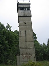
The Lappwald is first mentioned in a document as "Lapvualt" in 1147. There is no clear interpretation of the name for "Lappwald". The most likely thesis is based on the hunting concept of "lapping" . For many centuries, the Lappwald was a border forest between the Braunschweig and Prussian national territory. Numerous smugglers and other criminal persons, including the well-known “ robber captain Rose ”, took advantage of this border situation in the forest. In the 20th century, the inner German border divided the Lappwald, following the former Brunswick-Prussian border.
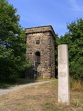
To the northeast of Helmstedt, in the Lappwald, there are remains of the Helmstedter Landwehr trenches in the direction of Walbeck . Two watchtowers from the 13th century, which are referred to as the 1st and 2nd Walbeck watchtower, have been preserved. Another medieval watchtower, the Magdeburg waiting , stands on the southern edge of the Lappwaldes southeast of Helmstedt near the junction of the road from Magdeburg gate from the direction of Magdeburg leading Bundesstraße 1 . This tower, rebuilt on remains, is about 10 m high and serves as a lookout tower .
Individual evidence
- ↑ a b Mountain height according to the topographical overview map of the Harz ( memento of the original from December 19, 2014 in the Internet Archive ) Info: The archive link has been inserted automatically and has not yet been checked. Please check the original and archive link according to the instructions and then remove this notice. (DTK 25; see large enlargement of the map), on natur-erleben.niedersachsen.de
- ^ Theodor Müller : Geographische Landesaufnahme: The natural space units on sheet 87 Braunschweig. Federal Institute for Regional Studies, Bad Godesberg 1962. → Online map (PDF; 4.8 MB)
- ↑ a b Map services of the Federal Agency for Nature Conservation ( information )
- ↑ Hans-Ehrhard Müller: Helmstedt - the history of a German city , 2nd edition 2004, p. 184
- ↑ Magdeburger Warte on www.warttuerme.de, accessed on October 4, 2019
- ↑ Magdeburger Warte on www.wolfgangroehl.de, accessed on October 4, 2019
Web links
- Tourismusgemeinschaft Elm-Lappwald e. V. , on elm-lappwald.de
- Elm-Lappwald Nature Park , private website at elm-asse-kultur.de
- Lappwald nature reserve , at nlwkn.niedersachsen.de

