Kropstädt
|
Kropstädt
Coordinates: 51 ° 57 ′ 39 " N , 12 ° 44 ′ 45" E
|
|
|---|---|
| Height : | 117 m above sea level NHN |
| Area : | 37.31 km² |
| Residents : | 1143 (December 31, 2016) |
| Population density : | 31 inhabitants / km² |
| Incorporation : | January 1, 2010 |
| Postal code : | 06889 |
| Area code : | 034920 |


Kropstädt is a village in Lutherstadt Wittenberg in Saxony-Anhalt . It includes the districts of Kropstädt, Jahmo, Köpnick and Wüstemark.
geography
Kropstädt is located about 13 km northeast of the city center in the Fläming Nature Park . On January 1, 2010, the previously independent community was incorporated into Lutherstadt Wittenberg together with the communities of Boßdorf and Straach . The districts of the former municipality were Jahmo, Köpnick and Wüstemark.
Attractions
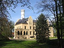
The Kropstädt Castle was from 1855 to 1856 by the then owner Adolf Friedrich Karl of Leipzig to plans by the Berlin architect Friedrich Hitzig built in the English Gothic style. In its place stood the Ließnitz moated castle in 1150. In the GDR era, the " Martha Brautzsch " maternity and baby home was located in the castle since the early 1950s . After the reunification and peaceful revolution in the GDR there was a hotel with a restaurant in the castle. Today (2018) it is privately owned and cannot be visited.
The church in Kropstädt was originally built as a stone church in the 13th century. Its current appearance goes back to a classical redesign in the 19th century, with which the field stones in the facade mostly disappeared. Only the apse in the eastern part of the building can still be seen in its original form.
Club life
Kropstädt has various non-profit associations: the Kropstädt 02 sports club (bowling, fitness, cycling), the KKC carnival club (founded in 1957) and the volunteer fire brigade's association . The Förderverein Schlosspark und Gutshof Kropstädt is committed to the maintenance and care of the green and courtyard areas.
Economy and Infrastructure
traffic
The Federal Highway 2 , the Berlin and Wittenberg connects directly through the district Kropstädts.
tourism
South of Kropstadt and within walking distance is the Friedenthaler Grund circular route , a hiking trail that connects the towns of Jahmo , Köpnick and Wüstemark over a total distance of 11 kilometers and mainly leads through the coniferous wood of the Kropstädter Heide.
Personalities
Sons and daughters of the church
- Martin Moller (1547–1606), mystic and hymn poet , co-founder of Evangelical Lutheran edification literature
- Friedrich August Wagner (1775–1856), doctor and archaeologist
- Hans Wintoch alias "Hans the violin" (* 1954), rock musician
- Hans-Eckardt Wenzel (* 1955), songwriter , musician and poet
- Cornelia Gödecke (* 1960), politician ( SPD )
- Alf Mahlo (* 1960), entertainer, actor and producer
- Hendrikje Wangemann (* 1961), soprano
- Raja Lubinetzki (* 1962), poet and painter
Personalities associated with Kropstädt
- Friedrich Wilhelm Curt von Leipziger (1761–1824), owner of the Kropstädt manor , district administrator of the Wittenberg district
- Karl von Leipziger (1848–1924), owner of the Kropstädt manor and member of the German Reichstag
- Thomas Höse (* 1967), politician ( AfD ), lives in Kropstädt
Web links
- History of the Kropstädt Castle
- Material on Schloss Kropstädt in the Duncker Collection of the Central and State Library Berlin (PDF; 263 kB)

