Circle of ears
| coat of arms | Germany map |
|---|---|

|

Coordinates: 52 ° 17 ' N , 11 ° 25' E |
| Basic data (as of 2007) | |
| Existing period: | 1994-2007 |
| State : | Saxony-Anhalt |
| Administrative headquarters : | Haldensleben |
| Area : | 1,493.61 km 2 |
| Residents: | 113,438 (Dec. 31, 2006) |
| Population density : | 76 inhabitants per km 2 |
| License plate : | OK |
| Circle key : | 15 3 62 |
| Circle structure: | 81 municipalities |
| District Administrator : | Thomas Webel ( CDU ) |
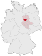
| Location of the Ohrekreis in Saxony-Anhalt | |
The Ohrekreis was a district in the northwest of Saxony-Anhalt. On July 1, 2007, it was merged with the Bördekreis to form the new Börde district as part of the regional reform in Saxony-Anhalt . Neighboring districts were the Altmarkkreis Salzwedel and the Stendal district in the north, the Jerichower Land district in the east, the independent city of Magdeburg and the Bördekreis in the south, and the Lower Saxony district of Helmstedt in the west and the Gifhorn district in the northwest .
geography
The area of the Ohrekreis was in the Magdeburg Börde and the Colbitz-Letzlinger Heide . The district was named after the river Ohre , which ran parallel to the Mittelland Canal from west to east through the district and emptied into the Elbe . In the west, the Aller River also flowed through the district.
economy
As part of the Magdeburger Börde , the district was mainly used for agriculture. Large industrial parks were built around Magdeburg and Haldensleben, especially near the A2 motorway.
traffic
Motorway (A2 and A14) as well as rail connections ran through the district that touched the state capital Magdeburg. The Mittelland Canal also ran through the district. The greater Magdeburg area was connected to the state capital by the Magdeburg S-Bahn .
history
The district was created in 1994 through the merger of the districts of Haldensleben and Wolmirstedt . There were also some communities in the Klötze district . The first and only district administrator in the new district was the former district administrator of the Wolmirstedt district, Thomas Webel ( CDU ).
1680–1806 today's district area roughly corresponded to the Brandenburg wooden circle .
During the district reform in 2007, the Ohrekreis was merged with its southern neighbor, the Bördekreis . The name of the new district is Landkreis Börde .
coat of arms
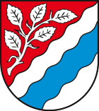
Blazon : "Diagonally left divided by a wave cut red over silver, above a five-leaf silver beech branch, below a blue wave oblique left bar."
The coat of arms was approved on May 11, 1995.
The blue sloping left-hand bar symbolizes the river Ohre, which meanders across the district, crosses the three cities of Oebisfelde, Haldensleben and Wolmirstedt and gave the district its name. The beech branch stands for the large beech forests of the Flechtinger ridge. The circle colors red and white are derived from the colors of the Archdiocese or Duchy of Magdeburg, to which the majority of the Ohrekreis belonged.
Territorial changes
Since 1995 there have been many changes to the area in the Ohrekreis.
Of the original 11 administrative communities, there were still 5 administrative communities when the district was dissolved. During the same time the number of parishes remained constant.
Changes in administrative communities
- Dissolution of the administrative community Niedere Börde - formation of the unit municipality Niedere Börde from the member communities (January 1, 2004)
- Dissolution of the Mittelland administrative community - formation of the Mittelland unified municipality (July 1, 2004)
- Dissolution of the administrative association Nördliche Börde - incorporation of the municipalities into the administrative association Hohe Börde (September 20, 2004)
- Formation of the administrative community Wolmirstedt from the municipality Farsleben from the administrative community Elbe-Ohre and the administrative community-free city Wolmirstedt (January 1, 2005)
- Formation of the administrative community Oebisfelde-Calvörde from the administrative communities Calvörde and Oebisfelde (January 1, 2005)
- Formation of the Flechtingen administrative community from the Beverspring , Flechtinger Höhenzug and Weferlingen administrative communities (January 1, 2005)
- Formation of the administrative community Elbe-Heide from the administrative communities Südheide , Südliche Altmark / Elbe and Elbe-Ohre (without the municipality of Farsleben) (January 1, 2005)
Name changes
- from Calvörde to Flecken Calvörde (April 16, 2002)
cities and communes
(Resident on December 31, 2006)
License Plate
On July 1, 1994, the district was assigned the distinguishing mark OK . It was issued in the Börde district until September 30, 2007. It has been available there again since November 27, 2012. This happened because of the license plate liberalization ; Since then , further letter combinations have also been possible.


