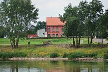
Heinrichsberg
|
Heinrichsberg
Municipality Loitsche-Heinrichsberg
|
|
|---|---|
| Coordinates: 52 ° 16'23 " N , 11 ° 44'3" E | |
| Height : | 40 m above sea level NHN |
| Area : | 11.34 km² |
| Residents : | 364 (Dec. 31, 2017) |
| Population density : | 32 inhabitants / km² |
| Incorporation : | January 1, 2010 |
| Postal code : | 39326 |
| Area code : | 039208 |
Location of Heinrichsberg in Saxony-Anhalt |
Heinrichsberg is a district of Loitsche-Heinrichsberg in the Börde district in Saxony-Anhalt .
geography
Heinrichsberg is located north of Magdeburg on the left bank of the Elbe , a few kilometers south of the mouth of the ear . Before its mouth, the Ohre flows almost parallel to the Elbe for about 10 km. The area in between is largely flat and diked. The former district town of Wolmirstedt is approx. 9 km away, Magdeburg city center approx. 22 km away. In the east of the Heinrichsberg district, the Elbe forms the border with the Jerichower Land district . The Ihle Canal (built between 1865 and 1872) connects the Elbe from Heinrichsberg with the Plauer Canal (today part of the Elbe-Havel Canal ).
Areas of several hundred hectares of land north and south of Heinrichsberg According to plans, the retention areas (including Altauen reactivation) by relocating dikes to flood control are supplied, leading to conflicts with the particular agricultural users.
history
The previously independent municipality of Heinrichsberg merged with Loitsche on January 1, 2010 to form the new municipality of Loitsche-Heinrichsberg .
politics
mayor
The last mayor of Heinrichsberg was Bettina Seidewitz.
coat of arms
The coat of arms was approved on November 17, 1995 by the Magdeburg Regional Council.
Blazon : "In silver over blue water a red tin tower with an open black gate and window opening, growing out of the tower a gold-armored black eagle looking to the left."
The coat of arms was designed by the Colbitz heraldist Günther Gembalski .
flag
The district flag of Heinrichsberg has red and white stripes and the coat of arms of the district is applied.
Economy and Infrastructure
Heinrichsberg is shaped by agriculture (dairy farm and agricultural cooperative Heinrichsberg eG). Of the clubs, the sports club and the fishing club are to be highlighted. SSV Heinrichsberg plays in the second highest division of the Börde district (Bördekreisliga). In 2005, the Heinrichsberg volunteer fire brigade celebrated its 125th anniversary.
Transport links
From Heinrichsberg road connections lead over the Ohrebrücke to Loitsche and Zielitz and south to Wolmirstedt and Magdeburg (Autobahn connection A 2 Magdeburg-Rothensee 9 km away). In Zielitz there is a rail connection to Magdeburg and Stendal .
Until 1955 there was a ferry connection across the Elbe to Niegripp opposite (today part of the district town of Burg )
Attractions
A few kilometers south of Heinrichsberg, the Magdeburg waterway intersection , the Rothensee ship lift and the Hohenwarthe lock are well worth seeing . In the village itself is the listed Heinrichsberg war memorial . Other monuments are the house at Rogätzer Strasse 46 and the gate system of the courtyard at Rogätzer Strasse 44 .


