Wenddorf
|
Wenddorf
Angern municipality
|
|
|---|---|
| Coordinates: 52 ° 22 ′ 59 ″ N , 11 ° 45 ′ 0 ″ E | |
| Height : | 37 m above sea level NHN |
| Area : | 6.51 km² |
| Residents : | 92 (December 31, 2017) |
| Population density : | 14 inhabitants / km² |
| Incorporation : | January 1, 2010 |
| Postal code : | 39517 |
| Area code : | 039363 |
|
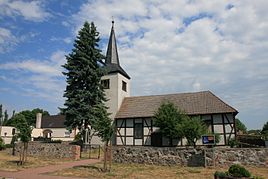
Protestant church
|
|
Wenddorf is a district of the municipality of Angern in the Börde district in Saxony-Anhalt.
geography
Wenddorf, east of the Colbitz-Letzlinger Heide, lies in the area of the Tanger source brooks, which flow in a fan shape towards the Tangerhütte . The surroundings of Wenddorf are slightly hilly and gradually rise to the west. The city of Wolmirstedt is about 19 km away.
history
The place name is derived from the Wends who used to settle here (one of the numerous streams near Wenddorf is still called Wendischer Bach today ). The history of the place is closely linked to the Angerns and its moated castle .
On January 1, 2010, the previously independent municipalities of Wenddorf, Bertingen and Mahlwinkel merged with the municipality of Angern to form the new municipality of Angern.
politics
mayor
The last mayor of the Wenddorf community was Egbert Knoost.
coat of arms
The coat of arms was approved on March 29, 1996 by the Magdeburg Regional Council.
Blazon : “In silver over a red shield base covered with a silver wavy bar; a green oak leaf with a green acorn on each side. "
Economy and Infrastructure
Wenddorf is predominantly characterized by agriculture.
Transport links
From Wenddorf country roads lead via Angern to Colbitz on the federal highway 189 ( Magdeburg - Stendal ) and via Mahlwinkel to Tangerhütte . The next train station is in Mahlwinkel, 5 km away (Magdeburg - Stendal line).
Individual evidence
Web links
- History of Angern Castle ( Memento from May 11, 2005 in the Internet Archive )

