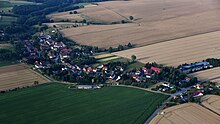
Weißenborn (Droyßig)
|
Weissenborn
Municipality of Droyziger
Coordinates: 51 ° 1 ′ 59 ″ N , 12 ° 0 ′ 0 ″ E
|
||
|---|---|---|
| Height : | 264 m | |
| Area : | 9.55 km² | |
| Residents : | 363 (December 31, 2008) | |
| Population density : | 38 inhabitants / km² | |
| Incorporation : | January 1, 2010 | |
| Postal code : | 06722 | |
| Area code : | 034425 | |
|
Location of Weißenborn in Saxony-Anhalt |
||
|
Church in Weißenborn
|
||
Weißenborn is a small village and has belonged to the municipality of Droyßig in the Burgenland district in Saxony-Anhalt since January 1, 2010 .
geography
Weißenborn is a Waldhufendorf and is located approx. 9 km west of Zeitz . Weißenborn, Stolzenhain and Romsdorf were designated as districts of the former municipality.
history
Weißenborn was first mentioned in a document in 1289 .
On January 1, 2010, the previously independent community of Weißenborn merged with the community of Droyßig to form the new community of Droyßig.
Culture and sights
In Weißenborn there is a local museum with a collection of ancient equipment and household items.
Economy and Infrastructure
traffic
The federal highway 180 , which leads from Zeitz to Naumburg , runs north of the municipality .
Personalities
- Johann Karl Zeune (1736–1788), German philologist, born in Stolzenhain
- Hans Hermann Russack (* 1887; year of death unknown), German art historian, born in Weißenborn
Web links
Commons : Weißenborn - Collection of pictures, videos and audio files


