Weissenfelser Land administrative association
| coat of arms | Germany map | |
|---|---|---|
 Help on coat of arms |
Coordinates: 51 ° 12 ' N , 11 ° 58' E |
|
| Basic data (as of 2010) | ||
| Existing period: | 2005-2010 | |
| State : | Saxony-Anhalt | |
| County : | Burgenland district | |
| Area : | 50.56 km 2 | |
| Residents: | 33,839 (Dec 31, 2007) | |
| Population density : | 669 inhabitants per km 2 | |
| License plate : | BLK | |
| Association structure: | 2 municipalities | |
| Association administration address : |
Markt 1 06667 Weißenfels |
|
| Website : | ||
| Head of the administrative community: | Manfred Rauner | |
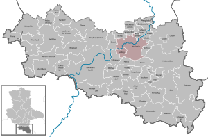
| Location of the Weißenfelser Land administrative community in the Burgenland district | ||
In the administrative community of Weißenfelser Land of the Burgenland district, the district town of Weißenfels and various then independent municipalities were united until August 31, 2010 to handle administrative business. The administrative seat was Weißenfels.
The administrative community was formed on January 1, 2005 from the formerly administrative community-free city of Weißenfels and the municipality of Markwerben from the dissolved administrative community Uichteritz . From July 1, 2007, Langendorf was a member of the administrative community. Leißling joined the company on January 1, 2009.
Langendorf and Markwerben were incorporated into Weissenfels on January 1, 2010. Leißling followed on September 1, 2010.
Member municipalities
- Langendorf (until the end of 2009)
- Chisel
- Market advertising (until the end of 2009)
- City of Weißenfels with Borau and Kleben


