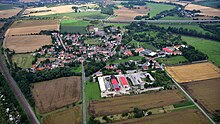
Schkortleben
|
Schkortleben
City of Weißenfels
Coordinates: 51 ° 14 ′ 32 ″ N , 12 ° 1 ′ 1 ″ E
|
|
|---|---|
| Height : | 92 m above sea level NN |
| Area : | 7.05 km² |
| Residents : | 337 (Nov. 7, 2017) |
| Population density : | 48 inhabitants / km² |
| Incorporation : | September 1, 2010 |
| Postal code : | 06688 |
| Area code : | 034446 |
|
Location of Schkortleben in Weißenfels
|
|
Schkortleben is a village and part of the city of Weißenfels in the Burgenland district in Saxony-Anhalt .
geography
Schkortleben is located northeast of Weißenfels on the left bank of the Saale . The district of Kriechau is also located in the district of Schkortleben. On the other side of the hall is the village of Oeglitzsch, which belongs to Lützen .
history
The corridor of Schkortleben was already settled in prehistoric times. Archaeological finds from the Neolithic, the Bronze Age and the Migration Period are evidence of this. According to older legends, King Heinrich I is said to have camped near Schkortleben in 933 before the Battle of Hungary. The community was first mentioned as Zeurtelebe around the year 1300 in the interest register fragment of the Weißenfelser Klarissenkloster . Later names such as Schorteleiben (1367), Scortleuben (1458) or Sckortleuwenn (1532) appear. From 1750 the name Schkortleben became established and was interpreted as "short, cut off or cut up".
A church was probably built in the second half of the 13th century. In 2000 it was demolished due to its dilapidation. In the village there was a manor owned by families v. Biesenrodt (17th century), v. Breitenbauch (18th century) and Scharf v. Gauerstaedt (1830–1913) belonged.
During the Thirty Years' War almost three quarters of the population died of hunger, the plague and the tribulations of the soldiers passing through. In the Seven Years' War (1756–1763) and during the Wars of Liberation, another difficult time began for the population. Troops passing through looted the place and took everything edible. In the 1st World War 1914–1918 Schkortleben had 16 dead and 4 missing, in the 2nd World War 1939–1945 18 dead.
In 1843 Schkortleben had 292 inhabitants. On September 1, 2010 Schkortleben was incorporated into Weissenfels.
In the neighborhood is the medieval desert Sahla .
politics
The municipality of Schkortleben, which was independent until its compulsory incorporation in 2010, is today a district and a town of the city of Weißenfels within the meaning of § 86 GO LSA . It thus has a local council and a local mayor.
Local council
The local council consists of ten elected local councils. The local mayor belongs to the local council ex officio and is chairman.
Local mayor
The local mayor has been Helmut Kühn since the forced incorporation in 2010. He also belongs to the city council of Weißenfels and is a member of the “Landgemeinden” faction.
Culture and sights
Buildings
- The village church in Kriechau, a single-nave neo-Gothic quarry stone building with a slim tower and pointed helmet
- Ruins of the church of Schkortleben, destroyed from 2000 to 2003.
wine growing
Burgwerben and Kriechau are northern branches of the Saale-Unstrut region .
Regular events
The 1. Schkortleben traditional club organizes the Whitsun Festival every year with Whitsun beer in the marquee, music, dance and entertainment.
traffic
The federal highway 91 , which leads from Weißenfels to Merseburg , the federal highway 38 and the Thuringian trunk line ( Halle (Saale) - Bebra ) run in the immediate vicinity of the village .
There the Groß Korbetha – Deuben railway branches off , on which since 1999 only coal trains have been running between Wählitz (just before Hohenmölsen) and Großkorbetha.
Web links
- Schkortleben on weissenfels.de
Individual evidence
- ↑ Main statute of the city of Weißenfels in the version of the announcement of January 27, 2015 (WSF-OJ No. 2/2015, p. 3), amended by the statutes of November 26, 2016 (WSF-OJ 11/2016, p. 3 ) . ( weissenfels.de [PDF; 275 kB ; accessed on October 20, 2017]).
- ↑ Saxony-Anhalt viewer of the State Office for Surveying and Geoinformation ( notes )
- ↑ See the legend that a hoof print of his horse was preserved in a stone in the Bad Dürrenberg spa gardens.
- ↑ War memorial 1914–1948 or information from the Volksbund War Graves Commission.
- ↑ Handbook of the Province of Saxony 1843 p. 269 No. 126.
- ↑ StBA: Area changes from January 01 to December 31, 2010
- ↑ Details on the earlier equipment etc. in Heidenreich, Gustav Heinrich: Church and School Chronicle of the City and Ephorie Weissenfels since 1539. Weissenfels 1840. pp. 322–328.


