
Prießnitz (Naumburg)
|
Priessnitz
City of Naumburg (Saale)
Coordinates: 51 ° 5 ′ 41 ″ N , 11 ° 46 ′ 50 ″ E
|
|
|---|---|
| Height : | 254 m |
| Area : | 6.49 km² |
| Residents : | 289 (Aug 2014) |
| Population density : | 45 inhabitants / km² |
| Incorporation : | January 1, 2010 |
| Postal code : | 06618 |
| Area code : | 034466 |
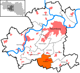  Location of Prießnitz in Naumburg (Saale)
|
|

Prießnitz is a district of the city of Naumburg (Saale) in the Burgenland district in Saxony-Anhalt .
geography
Prießnitz is located between Jena and Naumburg (Saale) on an elevated agricultural site south of the Saaleanhöhen near Naumburg.
history
While the document issued in 1196 for Prießnitz northeast of the small town of Camburg cannot be assigned with certainty, the mention of 1349/50 in the loan book of Friedrich des Strengen can be assigned with certainty. The place belonged to the Wettin district office of Eisenberg , which was under the sovereignty of various Ernestine duchies due to several divisions in the course of its existence .
On October 16, 1806, Prießnitz was attacked by French troops on the edge of the battle near Jena / Auerstedt. The Prießnitzern was erroneously accused of having attacked and robbed a French supply transport. The whole village was supposed to be burned down for this reason and seven young men shot on today's fear square, but the son of the pastor at the time, Christian Gottlob Großmann , knew the French language and was able to clear up the mistake. The seven youths were spared, they were shot over their heads. Every year around October 16, the event at that time is commemorated with a festival week.
In 1826 Prießnitz came with the northern part of the Eisenberg district office from the Duchy of Saxony-Gotha-Altenburg to the Duchy of Saxony-Meiningen and became part of the Camburg exclave. From 1922 to 1939 the place belonged to the Camburg district department , then to the Thuringian district of Stadtroda until 1948 , then briefly to the district of Jena . During the territorial reform of 1952 in the GDR , the place came to the Naumburg district in the Halle district , whereby its affiliation to Thuringia ended.
From January 1, 2008 until its dissolution on December 31, 2009, the community belonged to the Wethautal administrative community . On January 1, 2010, the previously independent community of Prießnitz was incorporated into the city of Naumburg (Saale) together with the communities of Crölpa-Löbschütz , Janisroda and the city of Bad Kösen .
traffic
The federal highway 88 , which leads from Jena to Naumburg (Saale), runs northwest of Prießnitz .
Individual evidence
- ↑ This certificate can also stand for the place Prittitz near Naumburg, see: Andrei Zahn : Die Prießnitz-Places, history of a confusion, in: Saale-Unstrut-Jahrbuch Vol. 2019, Naumburg 2018, pp. 31-42.
- ↑ StBA: Area changes from January 01 to December 31, 2010
Web links
Districts: Almrich | Grochlitz | Hen | Vineyards . Districts: Bad Kösen | Beuditz | Boblas | Crölpa-Löbschütz | Eulau | Flemmingen | Großjena | Großwilsdorf | Janisroda | Kleinjena | Meyhen | Neidschütz | Neuflemmingen | Prießnitz | Rossbach | Bell seat | Wettaburg . Districts of Bad Kösens: Fränkenau | Hassenhausen | Small herrings | Kukulau | Lengefeld | Punschrau | Rödigen | Saaleck | Push | School gate | Stendorf | Tultewitz .