
Starsiedel
|
Starsiedel
City of Lützen
Coordinates: 51 ° 13 ′ 3 ″ N , 12 ° 8 ′ 25 ″ E
|
||
|---|---|---|
| Height : | 140 m above sea level NN | |
| Area : | 5.47 km² | |
| Residents : | 677 (Dec. 31, 2008) | |
| Population density : | 124 inhabitants / km² | |
| Incorporation : | January 1, 2010 | |
| Postal code : | 06686 | |
| Area code : | 034444 | |
Location in Saxony-Anhalt |
||

Starsiedel is a district of the city of Lützen in the Burgenland district in Saxony-Anhalt.


geography
Starsiedel on the south-western edge of the Leipzig lowland bay between the cities of Weißenfels , Lützen , Zwenkau and Hohenmölsen is located on the slightly undulating, poorly forested plateau between the Saale in the west and the Weisse Elster in the east. The Starsiedel district has been spared the devastation caused by lignite mining - the former Profen-Nord opencast mine, southeast of Starsiedel, is reminiscent of large remaining holes and spoil heaps that have to be renatured.
The district of Kölzen belonged to the former municipality of Starsiedel.
The village of Rahna is to the east of Starsiedel .
history

Memorial in memory of the Battle of Großgörschen
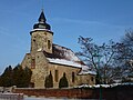
Starsiedel Church


In 1277 the name of the place Starsiedel (originally Slavic : Ztarcedele = old settlement) appeared for the first time in a document - at the same time as the later manor of Kölzen. The Starsiedler Church, mentioned in 1377, was replaced by the building of a new church in 1747 due to its dilapidation. Starsiedel and Kölzen belonged to the Hochstift-Merseburg office of Lützen until 1815 , which had been under Electoral Saxon sovereignty since 1561 and belonged to the secondary school principality of Saxony-Merseburg between 1656/57 and 1738 . In May 1813 the battle took place near Großgörschen , the neighboring village to the east of Starsiedel. A memorial stone in Starsiedel reminds of this.
As a result of the resolutions of the Congress of Vienna , the two places with the western part of the Lützen district came to Prussia in 1815. They were the 1816 Merseburg in the administrative district of Merseburg of the Province of Saxony allocated. The roads to Lützen and Kölzen were paved in 1884.

In 1945, first American troops and later Soviet troops occupied the community of Starsiedel. During the first district reform in the GDR, Starsiedel and its district of Kölzen were reclassified to the Weißenfels district on July 1, 1950. At the same time Sössen, Gostau and Stößwitz were incorporated into Starsiedel. With the second district reform in 1952, Starsiedel came to the Weißenfels district in the Halle district , which in 1990 became the Weißenfels district again and was incorporated into the Burgenland district in 2007. On January 1, 1957, Sössen, Gostau and Stößwitz formed the community Sössen , which was spun off from Starsiedel at the same time.
The Starsiedler elementary school was closed in 1971 due to the construction of a school in the neighboring community of Großgörschen . In the years from 1976 to 1983, the Starsiedler residents set up the connections to the central water supply network and the sewer system on their own initiative. After the political change, the former LPG (animal production) was incorporated into the Lützen agricultural cooperative.
On January 1, 2010, the previously independent communities of Starsiedel, Muschwitz , Poserna , Rippach and Großgörschen merged with the city of Lützen to form the new city of Lützen.
traffic
Two kilometers north of Starsiedel is the Lützen motorway junction on the A 38 from Göttingen to Leipzig , a few kilometers away the Rippachtal junction (connection to the A 9 from Berlin to Munich ). Other roads connect Starsiedel with Weißenfels , Lützen , Markkleeberg , Zwenkau and Hohenmölsen . The next train station is in Weißenfels.
Personalities
- Theodor Franz Christian von Seckendorff (1801–1858), Prussian diplomat
Individual evidence
- ^ Karlheinz Blaschke , Uwe Ulrich Jäschke : Kursächsischer Ämteratlas , Leipzig 2009, ISBN 978-3-937386-14-0 , p. 84 f.
- ^ The district of Merseburg in the municipal directory 1900
- ↑ Starsiedel on gov.genealogy.net
- ↑ Sössen and its districts on gov.genealogy.net
- ↑ StBA: Area changes from January 01 to December 31, 2010
