
Wöllnitz
|
Wöllnitz
City of Jena
Coordinates: 50 ° 54 ′ 13 " N , 11 ° 35 ′ 51" E
|
|
|---|---|
| Height : | 150–170 m above sea level NN |
| Area : | 2.62 km² |
| Residents : | 598 (December 31, 2017) |
| Population density : | 228 inhabitants / km² |
| Incorporation : | August 1, 1946 |
| Postal code : | 07749 |
| Area code : | 03641 |
 View from the Hummelsberg
|
|

Wöllnitz is a district of the independent city of Jena in Thuringia .
geography
Wöllnitz is located between the Jena district of Lobeda and the city center east of the Saale and on the expressway to Lobeda. The place is divided into Oberwöllnitz, Pennickental and Unterwöllnitz with the church of the village.
Wöllnitz is located in the so-called Pennickental , a side valley of the Saale valley. It is bounded in the north by the Kernberge and in the south by the Johannisberg . The Pennickenbach flows in the valley, the source of which is the so-called prince's fountain since the visit of Frederick the Magnanimous, who was released from captivity and returning home . This is a popular excursion destination and also appears again and again in research as a mineral and fossil site .
history
There are two assumptions for the interpretation of the place name:
- The name is derived as "Velnica" from the Slavic "vel", which means clearing. This is supported by the fact that the plateau above the village was cleared early on.
- The name goes back to the Old High German word "walmiso", which means moist mountain forest.
The place name is certainly also in connection with the name of the adjacent ridge, the Wöllmisse . In addition, a knightly family von Welnicz is mentioned in the 13th century.
In the 15th century the village was at times a fiefdom of the Würzburg bishops and in the 19th century it was owned by the Lords of Ziegesar.
In 1915 a cable car was put into operation, which transported tufa from the Pennickental to Burgau and was demolished again in 1938. Wöllnitz was temporarily incorporated into the municipality between 1922 and 1924.
The place is the subject of the last plowed beer state , the beer state zu Henneberg-Wöllnitz under the aegis of Corps Franconia Jena . A wheat beer brewery Eduard Barfuss und Söhne is occupied for the period from 1875 to 1983, as well as four more short-lived breweries.
Culture and sights
A striking feature of Stadtrodaer Strasse is the baroque shell limestone church , which was built between 1740 and 1743 as a central building instead of a previous building. It is an elongated octagon with a central, timbered tower and two rows of galleries . The clear windows at eye level allow passers-by to look inside. The organ comes from the Biedermeier period , the church was restored from 1966 to 1967.
In the churchyard there is the grave with a memorial stone of the last victim of a shock censorship in Jena, a fraternity member named Adolph Erdmannsdörffer from Altenburg , who died on July 26, 1845.

Village church

Wheat beer fountain in the Wöllnitz fire water pond
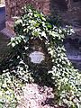
Grave of Adolph Erdmannsdörffer, on July 25th 1845 the last victim of the shock meter in Jena

Fürstenbrunnen


Web links
- Church information . Retrieved January 9, 2017
- Information on local history on the website of the Wöllnitz district council . Retrieved January 9, 2017
Individual evidence
- ↑ a b Ruth Kallies : Who knows the places, knows the names? - Old Jena locations from Alterstein to Wöllmisse. Jenzig-Verlag, Jena 2000, ISBN 3-910141-40-4 .
- ↑ a b c d Information on the Church . Retrieved January 9, 2017.
- ↑ Information about the cable car in Pennickental . Retrieved September 21, 2018.
- ↑ Historical brewery directory Germany of the federal states Brandenburg, Mecklenburg-Western Pomerania, Saxony, Saxony-Anhalt, Thuringia from approx. 1900 of the IBV Internationaler Brauereikultur-Verband e. V. IBV self-published, Stuttgart 1995.
- ^ Klaus Ehm: Historical Brewery Directory Germany (online) . Retrieved January 9, 2017.
- ↑ a b plaque at the church
- ↑ Birgitt Hellmann, Doris Weilandt: Jena musarum salanarum sedes: 450 years of the university city of Jena. Vopelius, Jena 2008, ISBN 978-3-939718-44-4 , p. 37. ( Google Books preview . Accessed January 9, 2017)
- ↑ epitaph

Ammerbach | Burgau | Closewitz | Cospeda | Drackendorf | Göschwitz | Ilmnitz | Isserstedt | Jena North | Jena-South | Jena-West | Jena Center | Jenaprießnitz / Wogau | Core mountains | Nativity Village | Kunitz / Laasan | Leutra | Lichtenhain | Lobeda Old Town | Löbstedt | Lützeroda | Maua | Münchenroda / Remderoda | Neulobeda | Fourteen saints | Fewjena | Winzerla | Wöllnitz | Goat grove | Zwätz