Weissdorf
| coat of arms | Germany map | |
|---|---|---|

|
Coordinates: 50 ° 11 ' N , 11 ° 51' E |
|
| Basic data | ||
| State : | Bavaria | |
| Administrative region : | Upper Franconia | |
| County : | court | |
| Management Community : | Sparneck | |
| Height : | 532 m above sea level NHN | |
| Area : | 21.9 km 2 | |
| Residents: | 1149 (Dec. 31, 2019) | |
| Population density : | 52 inhabitants per km 2 | |
| Postal code : | 95237 | |
| Area code : | 09251 | |
| License plate : | HO , MÜB , NAI, REH , SAN | |
| Community key : | 09 4 75 184 | |
| Community structure: | 13 districts | |
| Address of the municipal administration: |
Schwarzenbacher Str. 6 95237 Weißdorf |
|
| Website : | ||
| Mayor : | Heiko Hain (non-partisan Free Voting Community) | |
| Location of the community Weißdorf in the district of Hof | ||
Weißdorf is a municipality in the Upper Franconian district of Hof and a member of the Sparneck administrative community .
geography
location
Weißdorf is located on the northern edge of the Fichtelgebirge nature park on the Saale, about three kilometers east of the town of Münchberg and about 18 kilometers south of the town of Hof (Saale) .
Districts
The community of Weißdorf is divided into 13 districts:
|
|
history
Until the 19th century
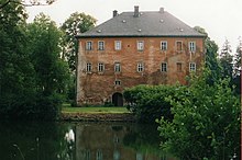
The first written mention of Weißdorf dates back to 1364. The von Sparneck family also counted the Weißdorf moated castle and the castle Uprode among their family castles . The former office of the Prussian principality of Bayreuth , which had been Prussian since 1792 , fell to France in the Peace of Tilsit in 1807 and became part of Bavaria in 1810. The barons of Podewils owned a manor there at that time.
Incorporations
In 1938 the neighboring community of Bug was dissolved and, like Oppenroth and Wulmersreuth (this from the community of Markersreuth), was incorporated into the community of Weißdorf. The district of Benk (previously Hallerstein municipality) volunteered on July 1, 1976. As part of the regional reform in Bavaria , the districts of Albertsreuth and Bärlas (previously the municipality of Seulbitz on the Saxon Saale) were reclassified to Weißdorf on May 1, 1978.
Population development
The population development of Weißdorf from 1840 to 2016:
|
|
|
In the period from 1988 to 2018, the population fell from 1254 to 1164 by 90 or 7.2%. On December 31, 1999, Weißdorf had 1,421 inhabitants.
politics
mayor
| May 1, 1978-30. April 1996 | Karl Kießling (ÜFWG) |
| May 1, 1996-30. April 2008 | Karl Baier (ÜFWG) |
| May 1, 2008–30. April 2014 | Herbert Gebhardt (Pro Weißdorf) |
| since May 1, 2014 | Heiko Hain (ÜFWG) |
Municipal council
The municipal council consists of 13 members (including the mayor).
| Non-partisan Free Voting Community | SPD and independents | Pro Weißdorf | Independent citizens | |
|---|---|---|---|---|
| 05/01/2002 - 04/30/2008 | 9 | 4th | - | - |
| 05/01/2008 - 04/30/2014 | 5 | - | 6th | 2 |
| 05/01/2014 - 04/30/2020 | 8th | - | 5 | - |
| from May 1st, 2020 | 10 | - | 3 | - |
coat of arms
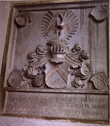
Description of coat of arms: In red a three-pass-shaped entwined silver ribbon.
Community partnerships
The municipality of Weißdorf maintains a partnership with the municipality of Werda in the Saxon Vogtland district .
Culture and sights

Buildings
- Late Gothic hall church of St. Maria from 1480
- Moated castle (privately owned, visits not possible)
- Uprode castle ruins
- Manor Bug
A grain and cutting mill was in operation in Weißdorf from 1472 to 1988. It initially belonged to the gentlemen von Sparneck zu Weißdorf and Bug.
Leisure, garden and sports facilities
- Garden of the allotment garden association Weißdorf
- Weißdorf an der Saale playground
- Sports facility of TuS Weißdorf (soccer field, tennis court, running track, long jump area, shot put area, sports home)
- Weißdorf gymnasium
- Weißdorf parish hall
Economy and Infrastructure
Economy including agriculture and forestry
According to official statistics, there were a total of 160 employees subject to social insurance contributions at the place of work in 2011. Of these, nine were employed in agriculture and forestry, 98 in the manufacturing sector, 21 in trade, transport and hospitality, eleven in the corporate service sector and 21 in the public and private sector. In 1998 there were still a total of 503 employees subject to social security contributions at the place of residence. There were four companies in the manufacturing sector. In addition, there were 42 farms in 1999 with an agricultural area of 2197 hectares, of which 973 hectares were arable land.
education
The following facilities exist:
- BRK day care center in Weißdorf
- Weißdorf-Sparneck elementary school
traffic
The community can be reached via the A 9 (Münchberg-Süd exit) and the A 93 (Rehau-Süd exit) and then via the B 289 that runs through Weißdorf .
The Münchberg – Zell railway line , which ran via Weißdorf, was closed on September 25, 1971.
Personalities
- Johann Wolfgang Döbereiner (1780–1849), German chemist, spent his childhood on the manor in Bug, which is now part of the Weißdorf community
literature
- Johann Kaspar Bundschuh : Weißdorf . In: Geographical Statistical-Topographical Lexicon of Franconia . tape 6 : V-Z . Verlag der Stettinische Buchhandlung, Ulm 1804, DNB 790364328 , OCLC 833753116 , Sp. 140-141 ( digitized version ).
- Pleikard Joseph Stumpf : Weißdorf . In: Bavaria: a geographical-statistical-historical handbook of the kingdom; for the Bavarian people . Second part. Munich 1853, p. 614 ( digitized version ).
Web links
- Entry on the coat of arms of Weißdorf in the database of the House of Bavarian History
Individual evidence
- ↑ "Data 2" sheet, Statistical Report A1200C 202041 Population of the municipalities, districts and administrative districts 1st quarter 2020 (population based on the 2011 census) ( help ).
- ↑ http://www.bayerische-landesbibliothek-online.de/orte/ortssuche_action.html?val=1245&attr=590&modus=automat&tempus=20100925/225026&hodie=20100925/225027
- ^ Wilhelm Volkert (ed.): Handbook of Bavarian offices, communities and courts 1799–1980 . CH Beck, Munich 1983, ISBN 3-406-09669-7 , p. 526 .
- ^ Federal Statistical Office (ed.): Historical municipality directory for the Federal Republic of Germany. Name, border and key number changes in municipalities, counties and administrative districts from May 27, 1970 to December 31, 1982 . W. Kohlhammer GmbH, Stuttgart / Mainz 1983, ISBN 3-17-003263-1 , p. 687 and 688 .
- ↑ Bavarian State Office for Statistics and Data Processing: [1]
- ^ Wilfried Kluge: Mills in Münchberg and in the old district of Münchberg . In: Münchberg - contributions to city history . Volume 2. Münchberg 1998. p. 148.
- ↑ Bavarian State Office for Statistics and Data Processing [2]


