
Konradsreuth
| coat of arms | Germany map | |
|---|---|---|

|
Coordinates: 50 ° 16 ' N , 11 ° 50' E |
|
| Basic data | ||
| State : | Bavaria | |
| Administrative region : | Upper Franconia | |
| County : | court | |
| Height : | 552 m above sea level NHN | |
| Area : | 43.25 km 2 | |
| Residents: | 3137 (Dec. 31, 2019) | |
| Population density : | 73 inhabitants per km 2 | |
| Postal code : | 95176 | |
| Area code : | 09292 | |
| License plate : | HO , MÜB , NAI, REH , SAN | |
| Community key : | 09 4 75 142 | |
| LOCODE : | DE KSU | |
| Community structure: | 36 districts | |
| Address of the municipal administration: |
Hofer Str. 8 95176 Konradsreuth |
|
| Website : | ||
| Mayor : | Matthias Döhla ( SPD ) | |
| Location of the municipality of Konradsreuth in the district of Hof | ||
  |
||

Konradsreuth is a municipality in the Upper Franconian district of Hof . The community is located in the Hofer Land .
geography
location
Konradsreuth is located between the Franconian Forest and the Fichtel Mountains and is crossed by the Münchberg gneiss slab. Hof Airport is not far from the municipality .
Districts
The municipality of Konradsreuth is divided into 36 districts:
|
|
|
history
Until the church is planted
Konradsreuth was first mentioned in 1266 in a document in which there was talk of an Ulricus de Conratsrute from the Lüchauer family . These came from Lobechow near Jena . The Lords of Lüchau ruled until 1485. In 1441, Emperor Friedrich III awarded them . a high court. Successors in the rule were from 1485 to 1495 Georg von Schirnding , from 1495 to 1597 the Rabensteiner zu Döhlau , from 1599 to 1610 Siegmund von Machwitz , from 1610 to 1629 the Lords von Haberland and from 1638 to 1646 Jareslaw Hofmann von Mönchhofen. In 1646 Georg Rudolph von Reitzenstein from Schönberg took over the knight's seat. In 1698 the castle was divided into settlement areas by two brothers: the lower part of the castle was given to Christoph Heinrich von Reitzenstein and the upper part of the castle to Georg Adam von Reitzenstein. In 1789, Traugott Leberecht von Reitzenstein sold the upper castle and all its possessions to Georg Christoph von Reitzenstein, owner of the lower part of the castle. Around 1815 the family of the Chamberlain from Weimar married . Descendants of the von Staff, called von Reitzenstein, are the owners of the castle.
The former office of the Prussian Principality of Bayreuth (as well as the condominium rights of the Barons von Reitzenstein) fell to France in the Peace of Tilsit in 1807, and the place became part of Bavaria in 1810 . In the course of the administrative reforms in Bavaria, today's municipality was created with the municipal edict of 1818 .
Change of name spelling
In 1903 the spelling of the municipality was officially changed from Conradsreuth to Konradsreuth .
Incorporations
On January 1, 1972, the previously independent municipality of Föhrenreuth was incorporated. On July 1, 1972, parts of the community Martinsreuth were added. Silberbach followed on January 1, 1975. On January 1, 1977, Konradsreuth received about 85 inhabitants from the dissolved municipality of Gottfriedsreuth and about 450 inhabitants from the dissolved municipality of Ahornberg and Markersreuth about 300 inhabitants on May 1, 1978.

Population development
In the period from 1988 to 2018, the population fell from 3383 to 3151 by 232 or 6.9%.
- 1910: 1462 inhabitants
- 1961: 3647 inhabitants
- 1970: 3759 inhabitants
- 1987: 3439 inhabitants
- 1991: 3491 inhabitants
- 1995: 3617 inhabitants
- 2000: 3627 inhabitants
- 2005: 3552 inhabitants
- 2010: 3212 inhabitants
- 2015: 3230 inhabitants
politics
Municipal council
The municipal council has 16 members. Another member and chairman of the municipal council is the mayor. In the local elections on March 15, 2020, 1,705 of the 2,606 residents entitled to vote in the municipality of Konradsreuth exercised their right to vote, bringing the turnout to 65.43%.
mayor
Mayor is Matthias Döhla (SPD). In the local elections on March 15, 2020, he was re-elected with 70.43% of the vote.
coat of arms
Above a silver shield base, in it a blue post (Herren von Lüchau) in red a silver sloping bar (Herren von Reitzenstein), covered by a golden shuttle with a silver thread spool lying on the left.
Economy and Infrastructure
Economy including agriculture and forestry
The municipal tax revenue amounted to 2,581,000 euros in 2011, of which 851,000 euros (net) were trade tax revenue.
In 1998, according to official statistics, there were 63 employees in the field of agriculture and forestry, 1,022 in the manufacturing sector and 315 in the field of trade and transport at the place of work. In other economic sectors, 133 people were employed at the place of work subject to social security contributions. There were a total of 1340 employees at the place of residence subject to social security contributions. There was one company in the manufacturing sector and seven companies in the construction sector. In addition, in 1999 there were 90 farms with an agricultural area of 2,703 hectares, of which 1959 hectares were arable land and 741 hectares were permanent green space.
traffic
The place is on the state road 2461 between Münchberg and Hof (Saale) . The A 9 motorway, which runs almost three kilometers to the west, can be reached via the Hof-West junction (AS 34).
The Hof-Plauen airfield is not far from the town .
education
In 2008 the following institutions existed:
- a kindergarten with 125 kindergarten places
- an elementary school with 19 teachers and 291 students
- Various vocational schools in the Ahornberg district: State vocational school, state vocational schools for housekeeping , child care , social care , hospitality professions and municipal specialist academies for social education and housekeeping
Sports
In table tennis, teams from TV Konradsreuth compete at district and state level.
Architectural monuments
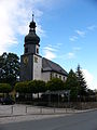
Parish church Konradsreuth

Konradsreuth Castle


literature
- Johann Kaspar Bundschuh : Conradsreuth . In: Geographical Statistical-Topographical Lexicon of Franconia . tape 1 : A-egg . Verlag der Stettinische Buchhandlung, Ulm 1799, DNB 790364298 , OCLC 833753073 , Sp. 538-539 ( digitized version ).
- Pleikard Joseph Stumpf : Konradsreuth . In: Bavaria: a geographical-statistical-historical handbook of the kingdom; for the Bavarian people . Second part. Munich 1853, p. 594 ( digitized version ).
Web links
- Entry on the coat of arms of Konradsreuth in the database of the House of Bavarian History
Individual evidence
- ↑ "Data 2" sheet, Statistical Report A1200C 202041 Population of the municipalities, districts and administrative districts 1st quarter 2020 (population based on the 2011 census) ( help ).
- ↑ http://www.bayerische-landesbibliothek-online.de/orte/ortssuche_action.html?val=1229&attr=590&modus=automat&tempus=20100925/182442&hodie=20100925/183625
- ↑ a b Wilhelm Volkert (Ed.): Handbook of the Bavarian offices, communities and courts 1799–1980 . CH Beck, Munich 1983, ISBN 3-406-09669-7 , p. 485 .
- ^ Federal Statistical Office (ed.): Historical municipality directory for the Federal Republic of Germany. Name, border and key number changes in municipalities, counties and administrative districts from May 27, 1970 to December 31, 1982 . W. Kohlhammer GmbH, Stuttgart / Mainz 1983, ISBN 3-17-003263-1 , p. 686 and 688 .
- ↑ Results of local elections 2020. OK.VOTE, March 15, 2020, accessed on May 19, 2020 .
- ↑ Results of local elections 2020. OK.VOTE, March 15, 2020, accessed on May 19, 2020 .
- ↑ Results of local elections 2020. OK.VOTE, March 15, 2020, accessed on May 19, 2020 .
- ↑ Bavarian State Office for Statistics and Data Processing, Statistics Kommunal 2012, https://www.statistik.bayern.de/statistikkommunal/09475142.pdf

Bad Steben | Mountain | Döhlau | Feilitzsch | Gattendorf | Geroldsgrün | Helmbrechts | Issigau | Köditz | Konradsreuth | Leupoldsgrün | Lichtenberg | Münchberg | Naila | Oberkotzau | Regnitzlosau | Rehau | Schauenstein | Schwarzenbach am Wald | Schwarzenbach an der Saale | Selbitz | Sparneck | Stammbach | Pots | Trogen | Weißdorf | Zell in the Fichtel Mountains
Unregulated areas:
Forst Schwarzenbach am Wald |
Gerlaser Forest |
Geroldsgrüner Forst |
Martinlamitzer Forst-Nord