
Schwarzenbach am Wald
| coat of arms | Germany map | |
|---|---|---|

|
Coordinates: 50 ° 17 ' N , 11 ° 37' E |
|
| Basic data | ||
| State : | Bavaria | |
| Administrative region : | Upper Franconia | |
| County : | court | |
| Height : | 686 m above sea level NHN | |
| Area : | 36.71 km 2 | |
| Residents: | 4323 (Dec. 31, 2019) | |
| Population density : | 118 inhabitants per km 2 | |
| Postal code : | 95131 | |
| Area code : | 09289 | |
| License plate : | HO , MÜB , NAI, REH , SAN | |
| Community key : | 09 4 75 169 | |
| LOCODE : | DE SZD | |
| City structure: | 41 districts | |
City administration address : |
Frankenwaldstrasse 16 95131 Schwarzenbach / Wald |
|
| Website : | ||
| Mayor : | Reiner Feulner ( CSU ) | |
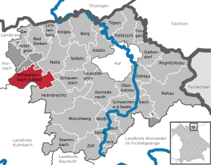
| Location of the town of Schwarzenbach am Wald in the Hof district | ||
  |
||


Schwarzenbach am Wald (officially: Schwarzenbach a.Wald ) is a town in the Upper Franconian district of Hof . Schwarzenbach am Wald is located at the foot of the Döbraberg in the Franconian Forest Nature Park . Schwarzenbach belongs to the Hofer Land .
City structure
The city is divided into 41 districts:
|
|
|
history
Schwarzenbach was first mentioned in a document on December 14, 1388. In the Middle Ages there was iron and copper mining there. The barons of Reitzenstein had a manor there. The former Oberamt of the Prussian Principality of Bayreuth , which had been Prussian since 1792 , fell to France in the Peace of Tilsit in 1807 and became part of Bavaria in 1810. Schwarzenbach had important magistrate rights. In the course of the administrative reforms in Bavaria , today's municipality was created with the municipal edict of 1818 . The market Schwarzenbach am Wald was elevated to a town on April 28, 1954.
On April 1, 1971, the previously independent community of Löhmar was incorporated. Meierhof was added on January 1, 1972. Bernstein am Wald, Döbra, Schwarzenstein and Straßdorf followed on May 1, 1978, with the town of Räumlas incorporated on April 1, 1971.
Population development
In the period from 1988 to 2018, the population fell from 5541 to 4395 by 1146 or by 20.7%. On December 31, 1992, the city had 5,908 inhabitants.
politics
City council
Up until the local elections on March 16, 2014 , the city council had 20 members who (as after the previous election in 2008) were divided between two factional communities :
- CSU / non-partisan home list 12 seats
- SPD / Free Community of Voters 8 seats
Since the local elections in 2020 , the city council consists of 16 members. The election resulted in the following distribution of seats:
- CSU / non-partisan home list 11 seats
- SPD / Free Community of Voters 5 seats
mayor
Reiner Feulner (CSU) has been the first mayor since 2018, his term of office lasts until 2026. His predecessor Dieter Frank (CSU) has been in office since 2002. The first mayor is also a member of the city council.
Culture and sights

Architectural monuments
memorial
In the local cemetery, seven graves with memorial stones commemorate concentration camp prisoners who perished and victims of forced labor during the Nazi regime .
Christian Keyßer House
On the outskirts of Schwarzenbach with a view of the Döbraberg is the Christian-Keyßer-Haus, the youth conference center of the Protestant deanery Naila . The concise building with the elongated roof is used in particular as a conference venue and as a leisure home, especially by church groups.
Economy and Infrastructure
traffic
Schwarzenbach am Wald is on the B 173 federal road . In addition, the city is connected to the route network of the Regionalbus Ostbayern (RBO) with connections to Kronach, Naila and Hof. On Sundays, the BEX bus connects the city with Berlin. In the summer months there are additional bus connections on the weekends with the OVF bicycle buses . From 1910 to 1973 Schwarzenbach am Wald was connected to the German railway network via the Naila – Schwarzenbach line. The route was closed in 1994 and later dismantled, and a cycle path was built in sections on the route.
Established businesses
- Deuta-Werke, precision turned and milled parts for automotive, railway and industry for 100 years
- Ströhla sawmill (Rauschenhammermühle), for over 340 years
- Thümling, textile machines
- Construction company Knoll
- REHAU
- REVEX Initiativ Zentrum, commercial center at the entrance to the village with various trades
- Revex-Flex, international sales and development of double pedals for driving schools
- Revex-Care, mobile solutions for people with disabilities
- Revex-IBox, advertising, design, print
- Stöcker, bus company
Sports facilities
- Municipal indoor swimming pool
- Urban ski lift
- Ski lift of the winter sports club
- various mountain bike routes
sons and daughters of the town
- Philipp Wolfrum (1854–1919), composer and organist
- Karl Wolfrum (1856–1937), composer and organist
- Wilhelm Kopf (1909–2001), diplomat in the Third Reich and later in the Federal Republic of Germany
- Matthias Herdegen (* 1957), lawyer, director of the Institute for Public Law and Director at the Institute for International Law at the Friedrich Wilhelms University in Bonn
literature
- Johann Kaspar Bundschuh : Schwarzenbach am Wald . In: Geographical Statistical-Topographical Lexicon of Franconia . tape 5 : S-U . Verlag der Stettinische Buchhandlung, Ulm 1802, DNB 790364328 , OCLC 833753112 , Sp. 244–245 ( digitized version ).
- Pleikard Joseph Stumpf : Schwarzenbach am Wald . In: Bavaria: a geographical-statistical-historical handbook of the kingdom; for the Bavarian people . Second part. Munich 1853, p. 616 ( digitized version ).
Web links
- Entry on the coat of arms of Schwarzenbach am Wald in the database of the House of Bavarian History
Individual evidence
- ↑ "Data 2" sheet, Statistical Report A1200C 202041 Population of the municipalities, districts and administrative districts 1st quarter 2020 (population based on the 2011 census) ( help ).
- ↑ www.bayerische-landesbibliothek-online.de
- ↑ The Evangelical Luth. Naila church district , published by Evang.-Luth. Dekanat Naila, Jedermann-Verlag, Hof / Saale 1954, p. 24 ( page no longer available , search in web archives ) Info: The link was automatically marked as defective. Please check the link according to the instructions and then remove this notice.
- ^ Wilhelm Volkert (ed.): Handbook of Bavarian offices, communities and courts 1799–1980 . CH Beck, Munich 1983, ISBN 3-406-09669-7 , p. 530 .
- ^ Federal Statistical Office (ed.): Historical municipality directory for the Federal Republic of Germany. Name, border and key number changes in municipalities, counties and administrative districts from May 27, 1970 to December 31, 1982 . W. Kohlhammer, Stuttgart / Mainz 1983, ISBN 3-17-003263-1 , p. 687 .
- ^ Website of the city of Schwarzenbach am Wald
- ^ City Council - City of Schwarzenbach a.Wald. City of Schwarzenbach am Wald, accessed on June 5, 2020 .
- ↑ Reiner Feulner is the new mayor of Schwarzenbach am Wald · extra-radio - my Hochfrankenradio - radio from Hof. extra-radio, accessed June 5, 2020 .
- ↑ Frankenwaldtag 2020 in Schwarzenbach am Wald · extra-radio - my Hochfrankenradio - radio from Hof. extra-radio, accessed June 5, 2020 .
- ↑ The CSU nominates its mayoral candidate - CSU / ÜHL Schwarzenbach a.Wald. CSU / ÜHL Schwarzenbach a.Wald, accessed on June 5, 2020 .
- ↑ Memorials for the Victims of National Socialism - A Documentation , Volume 1, Federal Agency for Civic Education , Bonn 1995, ISBN 3-89331-208-0 , p. 192

Bad Steben | Mountain | Döhlau | Feilitzsch | Gattendorf | Geroldsgrün | Helmbrechts | Issigau | Köditz | Konradsreuth | Leupoldsgrün | Lichtenberg | Münchberg | Naila | Oberkotzau | Regnitzlosau | Rehau | Schauenstein | Schwarzenbach am Wald | Schwarzenbach an der Saale | Selbitz | Sparneck | Stammbach | Pots | Trogen | Weißdorf | Zell in the Fichtel Mountains
Unregulated areas:
Forst Schwarzenbach am Wald |
Gerlaser Forest |
Geroldsgrüner Forst |
Martinlamitzer Forst-Nord
Outside | Amber on the forest | Breitengrund | Dobra | Cod mill | Gemeinreuth | Goehren | Gottmannsgrün | Grubenberg | Hohenzorn | Chicken Ground | Kleindöbra | Lark Hill | Löhmar | Löhmarmühle | Meierhof | Oberleupoldsberg | Pillmersreuth | Popp green | Poppengrund | Clearing glass | Rauschenhammermühle | Rodeck | Singer forest | Blow | Schönbrunn | Schönwald | Schmölz | Schübelhammer | Schwarzenbach am Wald | Schwarzenstein | Sorg | Street village | Strasshaus | Sweet good | Thiemitz | Throne | Returns | Unterleupoldsberg | Viceburg | Zuckmantel