
Trogen (Upper Franconia)
| coat of arms | Germany map | |
|---|---|---|

|
Coordinates: 50 ° 22 ' N , 11 ° 57' E |
|
| Basic data | ||
| State : | Bavaria | |
| Administrative region : | Upper Franconia | |
| County : | court | |
| Management Community : | Feilitzsch | |
| Height : | 508 m above sea level NHN | |
| Area : | 12.32 km 2 | |
| Residents: | 1417 (Dec. 31, 2019) | |
| Population density : | 115 inhabitants per km 2 | |
| Postal code : | 95183 | |
| Area code : | 09281 | |
| License plate : | HO , MÜB , NAI, REH , SAN | |
| Community key : | 09 4 75 182 | |
| Community structure: | 7 districts | |
| Address of the municipal administration: |
Kirchstrasse 4 95183 Trogen |
|
| Website : | ||
| Mayor : | Sven Dietrich ( CSU ) | |
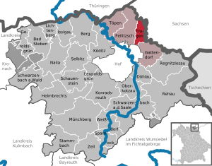
| Location of the municipality of Trogen in the district of Hof | ||
  |
||

Trogen is a municipality in the Upper Franconian district of Hof in Bavaria, right on the border with Saxony . The community is a member of the Feilitzsch administrative community . The core town is nestled between hills in a valley.
geography
Geographical location and traffic
Trogen is about six kilometers northeast of the independent city of Hof on the freeways 72 (junction 3 Hof / Töpen ), 93 (junction 2 Hof-Ost) and on the federal highway 173 . The Hochfranken motorway triangle is located in the area of the municipality . In the northernmost district of Föhrig, the Leipzig – Hof railway line touches the municipality. The northern Regnitz , a tributary of the Saale, flows through the community hallway . The municipality of Trogen is located in the Bavarian Vogtland on the border with Saxony , belongs to the district of Hof and thus also to the Upper Franconia region . The neighboring town of Feilitzsch is only a few hundred meters away from Trogen. The former inner-German border in the north and east of the municipality is now part of the German Green Belt . There are the nature reserves "Pfarrwiese" (near Föhrig), "Himmelreich" with the area natural monument "Grenzheide" (near Schwarzenstein) and "An der Ullitz" (near Ullitz).
Trogen has a comparatively closed townscape. Since the 1990s, however, clear tendencies towards urban sprawl have been observed, which are beginning to dissolve the previously very compact village through the designation of building land. Since 2012/2013, two wind farms on the plateau north-east of Trogen have dominated the townscape.
Neighboring places
|
Weischlitz (Saxony) |
||
| Feilitzsch |
.svg)
|
Triebel / Vogtl. (Saxony) |
| Hof (Saale) | Gattendorf |
Districts with population figures
Trogen consists of a total of seven districts:
- Föhrig 8 (north of the main town and the triangle of Upper Franconia on the Saxon border)
- Gössen
- Kienberg 239 (south of the main town)
- Schwarzenstein 10 (northeast of the main town on the A 93 and near the Saxon border)
- Trogen 1260
- Ullitz (southeast of the main town on the B 173 and on the Saxon border)
- Ziegelhütten 15 (northeast of the main town on the A 93)
history
Evidence for an early settlement of the area around Trogen are a barrow from the Bronze Age near Ullitz , a diamond-shaped resin boiling stone near Föhrig and the remains of a medieval stone cross in the cemetery in Trogen. A coin from the reign of King Wenzel II was also found in the ruins of the moated castle in Trogen, which burned down at the beginning of the 17th century . This so-called Prague groschen was minted between 1283 and 1305.
Trogen was first mentioned in a document on the inheritance contract of the Weida bailiffs from December 21, 1306. In this, the existing moated castle and the Vorwerke were divided as a fief between the three sons of Henry II the Rich . Trogen belonged with the Regnitzland between the 12th and 14th centuries to the administrative area of the Vögte von Weida, which is why the name Bayerisches Vogtland is used for this area today . In 1373 they sold their claims to the Burgraviate of Nuremberg , whose Upper Mountain share was owned by the later Margraves of Kulmbach-Bayreuth . The property has been called the Principality of Bayreuth since 1604 .
There were three knightly seats in Trogen (the Wasserburg , Trogen-Zech and the Obere Gut). The Trogen-Zech estates and the Obere Gut developed through division or sales from the Vorwerke of the Wasserburg. The Trogen moated castle, which according to old tradition is said to have been on the connection between the goods "Trogen-Zech" (address: Zech 1 in Trogen) and "Trogen-Oberes Gut" (address: Ullitzstrasse 7 in Trogen), belonged to the feudal lordship of the Counts of Reuss , who emerged from the bailiffs of Plauen . The water castle owned two half farms, a tavern, nine hostels, a farm in Feilitzsch and seven properties in Köditz . After the fire of 1637, the moated castle was no longer built. The Trogen-Zech farmyard belonged to the von Feilitzsch family . In terms of feudal law, it was initially subject to the governors of Weida until it was sold to the Burgrave Friedrich von Nürnberg in 1373 with the Regnitzland and the city of Hof. The Upper Good came into the Wettin - Saxon possession. After the Saxon-Brandenburg-Bayreuth border was established in the Treaty of Gefell in 1524, the Upper Gut belonged to the Margraviate of Brandenburg-Bayreuth, called the Principality of Bayreuth since 1604. The upper estate owned 17 farms in Trogen, three in Ullitz , four in Föhrig, two in Gössen and one in Schwarzenstein. A chapel with a cemetery was mentioned in a document in Trogen as early as 1366. After a fire in 1637, a new building was built. In 1747 today's baroque hall church was built. Until 1928 it was under the patronage of the Hof Church. The Trogen Church has been its own parish since 1928.
From 1498 Trogen was part of the "military district Hof", from which the provincial governing body Hof had developed in the first half of the 16th century . The place belonged to the hospital, caste, monastery and city bailiff's office in Hof. With the Principality of Bayreuth, Trogen fell to the Kingdom of Prussia in 1792 , then to France in the Peace of Tilsit in 1807 and to the Kingdom of Bavaria in 1810 . Trogen assigned this to the Mainkreis , which from 1817 was referred to as Obermainkreis and from 1838 as Upper Franconia . In the course of the administrative reforms in Bavaria, today's municipality was created with the municipal edict of 1818 . Trogen has belonged to the Free State of Bavaria since 1918 and to the Hof district since 1939. In 1935 the Hof - Chemnitz autobahn was built (today's federal autobahn 72 ).
During the time of the division of Germany after the Second World War (1945 to 1990) Trogen came into the immediate vicinity of the so-called inner - German border . Today's A 72 was used as an interzonal crossing between 1945 and 1951 because the Rudolphstein bridge on the Munich – Berlin motorway (today's A 9) was blown up in 1945. From 1951 to 1989 the motorway between Hof / Töpen (FRG) and Pirk (GDR) was closed to traffic. Until the rebuilding of the Saale valley viaduct in 1966, traffic was routed via federal road 2 - Töpen-Juchhöh border crossing. The road from Hof to Plauen (former federal highway 173 ) was closed in 1946 between Ullitz and Blosenberg and mined on the GDR side . On the north of Föhrig the former inner German border passing Leipzig-Hof railway there was interzonal passenger again since 1947th
With the turning point and the peaceful revolution in the GDR , the unnatural situation in the border area of the Trogen community ended in 1989/1990 . After the opening of the border to the GDR on November 10, 1989, a constant stream of cars rolled over the federal highway 173 through the district of Ullitz in the direction of Hof. Soon afterwards the A 72 could be used again. Trogen was again the link between Bavaria and Saxony. In the following period, the former inner German border in the north and east of the municipality was incorporated into the nature conservation project Green Belt Germany . In the municipality of Trogen there are the nature reserves “Pfarrwiese” (near Föhrig), “Himmelreich” with the area natural monument “Grenzheide” (near Schwarzenstein) and “An der Ullitz” (near Ullitz). With the completion of the northernmost section of the federal highway 93 , the Hochfranken triangle in the Trogener Flur was officially opened to traffic on December 15, 2000, after it had been planned since 1992 and built since 1996. Between 2012 and 2014 the two wind farms "Trogen I" (also: "Hochfranken I") and "Trogen II" (also: "Hochfranken II") with five turbines each were built in Trogen.
Population development
In the period from 1988 to 2018, the population fell from 1352 to 1423 by 71 or 5.3%. On December 31, 2003 Trogen had 1616 inhabitants.
- 1970: 1311 inhabitants
- 1987: 1334 inhabitants
- 1991: 1384 inhabitants
- 1995: 1570 inhabitants
- 2000: 1584 inhabitants
- 2005: 1627 inhabitants
- 2010: 1553 inhabitants
- 2015: 1435 inhabitants
politics
mayor
Sven Dietrich ( CSU ) has been mayor since 2020 . In the local election on March 15, 2020, he was elected with 58.07% of the vote.
Municipal council
The municipal council has 12 members. Another member and chairman of the municipal council is the mayor. In the local elections on March 15, 2020, 842 of the 1,171 residents eligible to vote in the Trogen municipality made use of their right to vote, resulting in a turnout of 71.90%.
coat of arms
The Trogen coat of arms dates from 1979.
Blazon : Above a silver crenellated shield base in black, a growing red armed and crowned golden lion, which holds a shield divided by silver, red and black in its front paws.
The three battlements symbolize the three knight seats Wasserburg, Trogen-Zech, and Oberes Gut. The lion is a symbol of the former governors of Weida . The shield comes from the coat of arms of the Barons von Feilitzsch .
Administrative community
Trögen is a member of the Feilitzsch administrative association .
Culture and sights


The elevated Evangelical-Lutheran church with a dominant baroque onion dome in the center is characteristic of the site. The town hall and the church parish hall are integrated into the ensemble. The community center is located in the vicinity as a place for social events. The church is a Protestant hall church with baroque furnishings and elements typical of the region, such as the baptismal angel and the pulpit altar . Other striking elements in the townscape are the two manor-like castles and the cemetery on the edge of the town with two small, striking buildings (chapel and mausoleum) on the ridge of a hill. The cultural and social life in the place is mainly supported by numerous associations and the parishes. A number of offers and activities relate to the neighboring town of Feilitzsch.
Economy and Infrastructure
Economy including agriculture and forestry
In 1998, according to official statistics, there were no employees at the place of work in the manufacturing industry 59 or in the trade and transport sector. There were a total of 531 employees at the place of residence subject to social security contributions. There were ten companies in the manufacturing sector and three in the construction sector. In addition, in 1999 there were 16 farms with an agricultural area of 827 hectares, of which 687 hectares were arable land and 140 hectares were permanent green space.
On a plateau on the edge of the core town there is an extensive area with wind turbines (Trogen I and Trogen II wind farms, see the list of wind turbines in Bavaria ).
education
The following institution existed in 1999:
- A kindergarten with 100 places and 106 children
Volunteer firefighter
FF Trogen has 146 members, 45 of them active. It has 4 vehicles, a road safety trailer (VSA) and a hay rake.
Sons and daughters of the church
- Dieter Mronz (* 1944), Lord Mayor of Bayreuth from 1988 to 2006
- Maximilian von Feilitzsch (1834–1913), Royal Bavarian State Minister of the Interior
Web links
- Entry on the coat of arms of Trogen (Upper Franconia) in the database of the House of Bavarian History
Individual evidence
- ↑ "Data 2" sheet, Statistical Report A1200C 202041 Population of the municipalities, districts and administrative districts 1st quarter 2020 (population based on the 2011 census) ( help ).
- ↑ http://www.bayerische-landesbibliothek-online.de/orte/ortssuche_action.html?val=1244&attr=590&modus=automat&tempus=20100915/083558&hodie=20100915/083600
- ↑ trogen.de:Chronik and history
- ^ The Trogen-Zech estate at www.alleburgen.de
- ↑ The Upper Gut at www.alleburgen.de
- ^ Chronicle of the Vogtland on the Vogtlandkreis website
- ↑ Hans-Joachim Fricke: The inner-German border and its effects on rail traffic. Zeit und Eisenbahn Verlag, Landsberg-Pürgen 1980, ISBN 3-921304-45-8 , p. 125 f.
- ^ Wilfried Rettig: The railways in Vogtland. Volume 1: Development, main lines, vehicles, depot and buildings. P. 185.
- ↑ Description of the Trogen I wind farm
- ↑ Description of the Trogen II wind farm
- ↑ Results of local elections 2020. OK.VOTE, March 15, 2020, accessed on May 20, 2020 .
- ↑ Results of local elections 2020. OK.VOTE, March 15, 2020, accessed on May 20, 2020 .
- ↑ Results of local elections 2020. OK.VOTE, March 15, 2020, accessed on May 20, 2020 .
- ^ Trogen municipality: Chronicle and history
- ↑ http://ngw.nl/heraldrywiki/index.php?title=Trogen
- ↑ Trogen Volunteer Fire Brigade. Retrieved June 25, 2020 .

Bad Steben | Mountain | Döhlau | Feilitzsch | Gattendorf | Geroldsgrün | Helmbrechts | Issigau | Köditz | Konradsreuth | Leupoldsgrün | Lichtenberg | Münchberg | Naila | Oberkotzau | Regnitzlosau | Rehau | Schauenstein | Schwarzenbach am Wald | Schwarzenbach an der Saale | Selbitz | Sparneck | Stammbach | Pots | Trogen | Weißdorf | Zell in the Fichtel Mountains
Unregulated areas:
Forst Schwarzenbach am Wald |
Gerlaser Forest |
Geroldsgrüner Forst |
Martinlamitzer Forst-Nord