
Issigau
| coat of arms | Germany map | |
|---|---|---|

|
Coordinates: 50 ° 23 ' N , 11 ° 43' E |
|
| Basic data | ||
| State : | Bavaria | |
| Administrative region : | Upper Franconia | |
| County : | court | |
| Management Community : | Lichtenberg | |
| Height : | 524 m above sea level NHN | |
| Area : | 18.69 km 2 | |
| Residents: | 1011 (Dec. 31, 2019) | |
| Population density : | 54 inhabitants per km 2 | |
| Postal code : | 95188 | |
| Primaries : | 09293, 09288, 09282 | |
| License plate : | HO , MÜB , NAI, REH , SAN | |
| Community key : | 09 4 75 137 | |
| LOCODE : | DE IGU | |
| Community structure: | 14 districts | |
| Address of the municipal administration: |
Dorfplatz 2 95188 Issigau |
|
| Website : | ||
| Mayor : | Dieter Gemeinhardt ( CSU ) | |
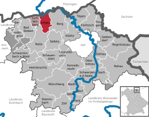
| Location of the community of Issigau in the district of Hof | ||
  |
||


Issigau is a municipality in the Hof district in Upper Franconia . The place of the same name is both the capital and the seat of the municipal administration.
geography
Geographical location
The community of Issigau is located on the eastern edge of the Franconian Forest Nature Park . The municipality is crossed by the Issig , a tributary of the Selbitz . The rivers Selbitz and Saale form the municipality boundary in the north and west. At the Unterwolfstein district, opposite Blankenstein , the Selbitz flows into the Saale. In the northwest, the Höllental lies partly on the municipality.
Neighboring communities
Adjacent municipalities are:
|
Rosenthal am Rennsteig Saale-Orla-Kreis Thuringia |
Rosenthal am Rennsteig Saale-Orla-Kreis Thuringia |
Rosenthal am Rennsteig Saale-Orla-Kreis Thuringia |
| Lichtenberg |
.svg)
|
mountain |
| Naila |
Districts
The districts of Issigau , Reitzenstein , Kemlas and Eichenstein exist in the municipality . The community of Issigau is divided into the following districts:
- Issigau
- The eponymous parish village lies on both sides of the Issig and is the seat of the municipal administration.
- The village of Reitzenstein is located near the road from Berg to Issigau. Until 1978 the village was the seat of an independent municipality. The area of the former municipality of Reitzenstein consisted of two non-contiguous parts around Reitzenstein and around Eichenstein.
- The village is located near the road from Lichtenberg to Eisenbühl . On January 1, 1975, Kemlas was incorporated.

- The scattered settlement is located near the road from Issigau to Hölle on the edge of the Höllental . Until 1978 the place was part of the Reitzenstein community.
- Geographic coordinates 50 ° 23 ' N , 11 ° 42' E
- Population: 30
- Altitude 570 m above sea level NN
- Griesbach

- The village on the road from Reitzenstein to Marxgrün belonged to Reitzenstein before the territorial reform.
- Wolfstein
- The hamlet north of Issigau on the connection route to Blankenstein was part of the Reitzenstein community until 1978.
- Heinrichsdorf
- The wasteland on the way from Issigau to Marxgrün was also part of Issigau before the regional reform.
- Preußenbühl
- The single settlement on the road between Issigau and Hölle belonged to the community of Issigau even before 1978.

- Kupferbühl
- The isolated settlement on the road between Issigau and Hölle was part of Reitzenstein's municipality before the 1978 regional reform.
- Neuenmühle
- The sawmill on the road between Issigau and Hölle belonged to the Reitzenstein community before the regional reform.
- Saarhaus
- The former Reitzenstein district of Saarhaus is located near the road from Issigau to Hölle.
- Sintered turf
- The isolated settlement is hidden in the forest near the road from Reitzenstein to Griesbach. It was a district of Reitzenstein.
- Oberkemlas
- The wasteland is north of Issigau on the connection route to Blankenberg and was part of the Kemlas community until the end of 1974.
- Lower cemlas
- The wasteland was part of the Kemlas parish. It is located directly on the road from Lichtenberg to Eisenbühl .
- Untereichenstein
- The single settlement on the Saale opposite Blankenstein belonged to Reitzenstein until 1978. In some documents, the name is also used for a single settlement on the road between Issigau and Hölle. The individual settlement belonged to Reitzenstein before the regional reform.
- Unterwolfstein
- Directly next to Untereichenstein on the Saale opposite Blankenstein is the single settlement Unterwolfstein. Until 1978 it was part of Reitzenstein.
history

Until the church is planted
Issigau was first mentioned in a document in 1398. The village was first part of the Reitzenstein manor. Issigau later became an independent manor. In 1796 the property was sequestered by Prussia . In the Peace of Tilsit in 1807 Issigau and the Prussian Principality of Bayreuth fell to France and then came to Bavaria. The spelling of the name varied over time between Ißiga , Issigau , Issigau , Issigau and Issigau . The place is called Nissja in dialect . The municipality of Issigau was created in the course of the administrative reforms in Bavaria with the municipal edict of 1818 .
20th century
At the beginning of the 20th century there were considerations for a railway connection to Hell in the form of a branch line of Group III. The following stations were planned: Hölle (station , branching off from the Triptis – Marxgrün railway line ), Neuenmühle = Eichenstein (Hp.), Issigau (Hst.) And Reitzenstein (Lbf.). In the turmoil of the war and post-war period, the project came to a standstill.
Incorporations
On the occasion of the municipal area reform , the previously independent municipality of Kemlas was incorporated on January 1, 1975. On May 1, 1978, the majority of the dissolved Reitzenstein community was added.
church
Population development
In the period from 1988 to 2018, the population decreased from 1241 to 1011 by 230 or 18.5%.
|
|
|
(Source: Bavarian State Office for Statistics and Data Processing)
politics
Municipal council
The municipal council has 12 members. Another member and chairman of the municipal council is the mayor. In the local elections on March 15, 2020, 624 of the 858 residents in the municipality of Issigau exercised their right to vote, bringing the turnout to 72.73%.
mayor
First Mayor Dieter Gemeinhardt (CSU) has been in office since November 2000. In the local elections on March 15, 2020, he was re-elected with 71.83% of the vote.
administration
The community is a member of the Lichtenberg administrative community .
coat of arms
|
|
Blazon : “With a curled black tip, a silver mallet and a silver iron, split by silver and gold, covered with two facing half red wings, the front one covered with a silver oblique left bar, the rear one with a silver inclined bar. " |
Economy and Infrastructure
The following companies are based:
- Künzel wood, sawmill and planing mill
- Reitzenstein estate management
- Campsite Schloss Issigau
Culture and sights
Wiedeturm
- The Wiedeturm is an 18.55 m high observation tower belonging to the Franconian Forest Association . He was in 1903 about one kilometer north of the Wolfstein community on the 549 m above sea level of the same name . NHN high mountain Wolfstein built. The tower was named after Anton Wiede, who ran the Rosenthal paper factory in Blankenstein, one kilometer away, on the south-west bank of the Saxon Saale . The Wiedeturm is only a few hundred meters away from the meeting point of the Rennsteig , Frankenweg and Fränkischer Gebirgsweg hiking trails .
Traveling turnstile
- Directly on the border with Thuringia at the bridge over the Selbitz to Blankenstein is the hiking hub in Untereichenstein, where four supraregional hiking trails meet, namely the Rennsteig , the Frankenweg , the Kammweg Erzgebirge – Vogtland and the Franconian Mountain Trail . Large, illustrated information boards provide detailed information on these hiking trails.
societies
- The gymnastics club (TV) Issigau has been organizing sport in Issigau since 1897. Today the focus is on dancing, gymnastics and unicycling.
- The football team of VfL Issigau 1921 plays in the Frankenwald district of the Bavarian Football Association.
- In 1951 the SC Eichenstein-Issigau was founded. The club was originally a pure ski club and the district of Eichenstein is one of the cradles of cross-country skiing in the Franconian Forest. If there is enough snow, a cross-country ski run Issigau – Reitzenstein – Sinterrasen – Griesbach – Issigau is operated. The association takes part in competitions and is active in table tennis in addition to cross-country skiing .
- The Miners' Association Issigau was founded in 1959. The association reminds of the mining tradition in Issigau. Every year in December there is a Barbara celebration .

- The Tractor Friends Reitzenstein collect and maintain old tractors and take part in tractor meetings with them in the region and beyond. The club is also represented at the vintage tractor world championships. In 2008 the World Championships were held on the Großglockner in Austria .
- In Issigau, Reitzenstein and Kemlas there are voluntary fire brigades and associated fire brigade associations.
Regular events
- A village festival is held every summer.
- In the Reitzenstein district, the Reitzenstein Tractor Friends organize a tractor meeting with skill drives, a tractor show and a trip from the Reitzenstein district to Issigau and back every year in June.
Architectural monuments
Web links
- Local government
- Link catalog on Issigau at curlie.org (formerly DMOZ )
- Issigau: Official statistics of the LfStat
Individual evidence
- ↑ "Data 2" sheet, Statistical Report A1200C 202041 Population of the municipalities, districts and administrative districts 1st quarter 2020 (population based on the 2011 census) ( help ).
- ↑ a b c Federal Statistical Office (ed.): Historical municipality directory for the Federal Republic of Germany. Name, border and key number changes in municipalities, counties and administrative districts from May 27, 1970 to December 31, 1982 . W. Kohlhammer GmbH, Stuttgart / Mainz 1983, ISBN 3-17-003263-1 , p. 686 and 688 .
- ↑ [1]
- ^ Robert Zintl, Bayerische Nebenbahnen, Stuttgart 1977, ISBN 3-87943-531-6
- ↑ Results of local elections 2020. OK.VOTE, March 15, 2020, accessed on May 19, 2020 .
- ↑ Results of local elections 2020. OK.VOTE, March 15, 2020, accessed on May 19, 2020 .
- ↑ Municipal Council / Commissioner. Issigau community, accessed on August 26, 2020 .
- ↑ Results of local elections 2020. OK.VOTE, March 15, 2020, accessed on May 19, 2020 .
- ^ Entry on the coat of arms of Issigau in the database of the House of Bavarian History
- ↑ re tower on the website of the Frankenwald eV
- ↑ http://www.issigau.de/
- ↑ Frankenpost dated September 12, 2008
- ↑ http://www.traktorwm.at/

Bad Steben | Mountain | Döhlau | Feilitzsch | Gattendorf | Geroldsgrün | Helmbrechts | Issigau | Köditz | Konradsreuth | Leupoldsgrün | Lichtenberg | Münchberg | Naila | Oberkotzau | Regnitzlosau | Rehau | Schauenstein | Schwarzenbach am Wald | Schwarzenbach an der Saale | Selbitz | Sparneck | Stammbach | Pots | Trogen | Weißdorf | Zell in the Fichtel Mountains
Unregulated areas:
Forst Schwarzenbach am Wald |
Gerlaser Forest |
Geroldsgrüner Forst |
Martinlamitzer Forst-Nord