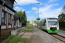
Rosenthal on the Rennsteig
| coat of arms | Germany map | |
|---|---|---|
 Help on coat of arms |
Coordinates: 50 ° 24 ' N , 11 ° 42' E |
|
| Basic data | ||
| State : | Thuringia | |
| County : | Saale-Orla district | |
| Height : | 640 m above sea level NHN | |
| Area : | 56.49 km 2 | |
| Residents: | 3989 (Dec. 31, 2019) | |
| Population density : | 71 inhabitants per km 2 | |
| Postal code : | 07366 | |
| Primaries : | 036642, 036651 | |
| License plate : | SOK, LBS, PN, SCZ | |
| Community key : | 16 0 75 136 | |
| Community structure: | 10 districts | |
| Address of the municipal administration: |
Rennsteig 2 Blankenstein district 07366 Rosenthal am Rennsteig |
|
| Mayor : | Peter Keller (Free Voters Rosenthal) | |
| Location of the municipality of Rosenthal am Rennsteig in the Saale-Orla district | ||
Rosenthal am Rennsteig is a municipality in the Saale-Orla district in the German state of Thuringia that was created on January 1, 2019 . 4048 inhabitants live in the municipality. (As of December 31, 2017)
geography
Community structure
The community consists of the districts Arlas , Birkenhügel , Blankenberg , Blankenstein , Harra , Hornsgrün , Kießling , Lemnitzhammer , Neundorf , Pottiga and Schlegel .
Neighboring communities
Neighboring communities, starting from the west and clockwise, are: Wurzbach , Bad Lobenstein , Gefell and Hirschberg in the Saale-Orla district and Berg , Issigau , Lichtenberg and Bad Steben in the Upper Franconian district of Hof .
The closest regional center is Hof (Saale) .
history
As part of the voluntary amalgamation of the regional reforms in 2018 and 2019, the seven member communities of the Saale-Rennsteig administrative community agreed on a merger on January 1, 2019. The merger was decided by the state parliament on December 13, 2018 and came into force on January 1, 2019. The Rosenthal pulp and paper factory and the eastern end of the Rennsteig are located in the newly named municipality .
traffic
The federal motorway 9 runs east past Rosenthal am Rennsteig. The Unterlemnitz – Blankenstein railway line (part of the Triptis – Marxgrün railway line ) with the Harra and Harra Nord stops and the Blankenstein train station runs through the municipality . For passenger traffic, the route is served every two hours (as of 2019) by Erfurt Bahn trains from Saalfeld to Blankenstein .
Web links
- Website (under construction)
Individual evidence
- ^ Population of the municipalities from the Thuringian State Office for Statistics ( help on this ).
- ↑ Peter Keller is the first elected mayor of the community of Rosenthal am Rennsteig on OTZ.de (accessed on May 27, 2019)
- ↑ Thuringian Law and Ordinance Gazette No. 14/2018 p. 795 ff. , Accessed on January 2, 2019


