
Seisla
| coat of arms | Germany map | |
|---|---|---|

|
Coordinates: 50 ° 39 ' N , 11 ° 32' E |
|
| Basic data | ||
| State : | Thuringia | |
| County : | Saale-Orla district | |
| Management Community : | Ranis-Ziegenrück | |
| Height : | 350 m above sea level NHN | |
| Area : | 4.47 km 2 | |
| Residents: | 135 (Dec 31, 2019) | |
| Population density : | 30 inhabitants per km 2 | |
| Postal code : | 07389 | |
| Area code : | 03647 | |
| License plate : | SOK, LBS, PN, SCZ | |
| Community key : | 16 0 75 103 | |
| Community structure: | 2 districts | |
| Association administration address: | Pößnecker Str. 2 07389 Ranis |
|
| Website : | ||
| Mayoress : | Heiderose Erler | |
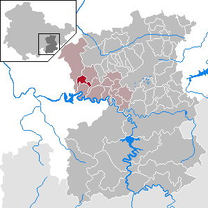
| Location of the municipality of Seisla in the Saale-Orla district | ||
  |
||

Seisla is a municipality in the Ranis-Ziegenrück administrative community in the Saale-Orla district in Thuringia .
geography
Seisla is on the road from Koenitz to Ranis .
Community structure
The community consists of the districts Seisla and Wöhlsdorf .
Neighboring communities
Adjacent communities are (clockwise) Krölpa , the city of Ranis, Schmorda and Wilhelmsdorf .

history
Seisla was first mentioned on September 30, 1381. A fortified church was built in 1230 . It was later replaced by today's hall church . Until 1815, Seisla belonged to the electoral office of Arnshaugk and after its assignment, decided at the Congress of Vienna , came to the Prussian district of Ziegenrück , to which the place belonged until 1945.
The district of Wöhlsdorf only developed from a manor and a few smaller farms after the Second World War .
Population development
Development of the population (from 1994: as of December 31) :
|
|
|
|
|
- Data source from 1994: Thuringian State Office for Statistics
coat of arms
In blue hovers over two silver-edged red rafters reaching to the middle, a golden balance and a golden sword above it with the edge pointing to the left .
Web links
Individual evidence
- ^ Population of the municipalities from the Thuringian State Office for Statistics ( help on this ).
- ^ Wolfgang Kahl : First mention of Thuringian towns and villages. A manual. 5th, improved and considerably enlarged edition. Rockstuhl, Bad Langensalza 2010, ISBN 978-3-86777-202-0 , p. 262.
- ^ A b Michael Rademacher: German administrative history from the unification of the empire in 1871 to the reunification in 1990. Ziegenrück district. (Online material for the dissertation, Osnabrück 2006).
Bad Lobenstein | Bodelwitz | Dittersdorf | Döbritz | Dreitzsch | Eßbach | Gefell | Geroda | Gertewitz | Görkwitz | Göschitz | Gössitz | Grobengereuth | Hirschberg | Keila | Cherry chew | Kospoda | Krölpa | Langenorla | Lausnitz | Lemnitz | Löhma | Miesitz | Mittelpöllnitz | Moßbach | Moxa | Neundorf (near Schleiz) | Neustadt an der Orla | Nimritz | Oberoppurg | Oettersdorf | Oppurg | Paska | Peuschen | Plot | Pörmitz | Pößneck | Quaschwitz | Ranis | Remptendorf | Rosendorf | Rosenthal am Rennsteig | Saalburg-Ebersdorf | Schleiz | Lubricating seat | Schmorda | Schondorf | Seisla | Solkwitz | Tanna | Tegau | Tommelsdorf | Triptis | Volkmannsdorf | Weira | Wernburg | Wilhelmsdorf | Wurzbach | Ziegenrück