
Rosendorf (Thuringia)
| coat of arms | Germany map | |
|---|---|---|
.png)
|
Coordinates: 50 ° 46 ' N , 11 ° 47' E |
|
| Basic data | ||
| State : | Thuringia | |
| County : | Saale-Orla district | |
| Management Community : | Triptis | |
| Height : | 355 m above sea level NHN | |
| Area : | 6.23 km 2 | |
| Residents: | 159 (Dec. 31, 2019) | |
| Population density : | 26 inhabitants per km 2 | |
| Postal code : | 07819 | |
| Area code : | 036481 | |
| License plate : | SOK, LBS, PN, SCZ | |
| Community key : | 16 0 75 093 | |
| Address of the municipal administration: |
Zwackau 27 07819 Rosendorf |
|
| Website : | ||
| Mayoress : | Sabine Gerschner (FWG Rosendorf / Zwackau) | |
| Location of the municipality of Rosendorf in the Saale-Orla district | ||
  |
||

Rosendorf is a municipality in the north-eastern Saale-Orla district ( Thuringia ).
geography
The community is located on a ridge on the right bank of the Orla , about eight kilometers northwest of the city of Triptis .
Community structure
The community consists of the districts of Rosendorf and Zwackau .
history
Rosendorf was first mentioned in a document on October 4, 1209 under the name Hungersdorf . It was not until the 17th century that the village received its current name. Zwackau was first mentioned in a document with the name Cwackow (Cwakow) in a fiefdom register from 1378 .
The current church was built in 1787 instead of an older predecessor church.
On July 1, 1950, the previously independent community of Zwackau was incorporated.
Population development
Development of the population (December 31st each) :
|
|
|
|
|
- Data source: Thuringian State Office for Statistics
politics
Municipal council
The council of the community consists of 6 councilors and councilors.
|
Distribution of seats by the municipal council in 2019
A total of 6 seats
|
||||||||||||||||||
| Parties and constituencies | 2019 | 2014 | 2009 | 2004 | 1999 | 1994 | ||||||||||||
|---|---|---|---|---|---|---|---|---|---|---|---|---|---|---|---|---|---|---|
| Share a | Seats | Share a | Seats | Share a | Seats | Share a | Seats | Share a | Seats | Share a | Seats | |||||||
| Free community of voters | 81.4 | 6th | - | - | - | - | - | - | - | - | 89.8 | 5 | ||||||
| Free voters Rosend./Zwack | - | - | 75.8 | 6th | - | - | 75.5 | 6th | 77.2 | 6th | - | - | ||||||
| FREE VOTERS | FW | - | - | - | - | 81.5 | 6th | - | - | - | - | - | - | |||||
| Christian Democratic Union | CDU | - | - | - | - | - | - | - | - | - | - | 10.2 | 1 | |||||
| other candidates | 18.7 | - | 24.3 | - | 18.5 | - | 24.5 | - | 22.9 | - | - | - | ||||||
| percentage of invalid votes | 0.9 | 0.9 | 0.9 | 1.8 | 5.2 | 3.2 | ||||||||||||
| Total seats | 6th | 6th | 6th | 6th | 6th | 6th | ||||||||||||
| voter turnout | 73.3% | 77.4% | 69.2% | 77.2% | 79.2% | 89.5% | ||||||||||||
coat of arms
The coat of arms was approved on January 9, 1995 by the Thuringian State Administration Office.
Blazon : "Under a green serrated shield head, in which a golden ear pointing to the left, in silver a red rose with a golden lug and green sepals."
The green head of the shield with the golden ear symbolizes the main branches of business in both districts of Rosendorf and Zwackau, namely agriculture and forestry. A rose was added to the coat of arms as a talking symbol for the district of Rosendorf.

Place name sign for Rosendorf
Center of Rosendorf

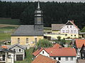
Church of Rosendorf

Half-timbered yard in Rosendorf


Individual evidence
- ^ Population of the municipalities from the Thuringian State Office for Statistics ( help on this ).
- ^ Wolfgang Kahl : First mention of Thuringian towns and villages. A manual. 5th, improved and considerably enlarged edition. Rockstuhl, Bad Langensalza 2010, ISBN 978-3-86777-202-0 , pp. 238, 327.
- ↑ City council elections 2019 in Thuringia - final result. In: wahlen.thüringen.de. Retrieved February 6, 2020 .
- ↑ 2014 municipal council elections in Thuringia - final result. In: wahlen.thüringen.de. Retrieved February 6, 2020 .
- ↑ 2009 municipal council elections in Thuringia - final result. In: wahlen.thüringen.de. Retrieved February 6, 2020 .
- ^ 2004 municipal council elections in Thuringia - final result. In: wahlen.thüringen.de. Retrieved February 6, 2020 .
- ^ 1999 municipal council elections in Thuringia - final result. In: wahlen.thüringen.de. Retrieved February 6, 2020 .
- ^ 1994 municipal council elections in Thuringia - final result. In: wahlen.thüringen.de. Retrieved February 6, 2020 .
- ↑ Hartmut Ulle: New Thuringian Wappenbuch. Volume 2: Ilmkreis, Jena, Kyffhäuserkreis, Saale-Orla-Kreis, Saalfeld-Rudolstadt (district), Schmalkalden-Meiningen (district), Suhl. 2nd, changed, revised edition. Working group Genealogy Thuringia, Erfurt 1997, ISBN 3-9804487-2-X , p. 49.
Web links
Bad Lobenstein | Bodelwitz | Dittersdorf | Döbritz | Dreitzsch | Eßbach | Gefell | Geroda | Gertewitz | Görkwitz | Göschitz | Gössitz | Grobengereuth | Hirschberg | Keila | Cherry chew | Kospoda | Krölpa | Langenorla | Lausnitz | Lemnitz | Löhma | Miesitz | Mittelpöllnitz | Moßbach | Moxa | Neundorf (near Schleiz) | Neustadt an der Orla | Nimritz | Oberoppurg | Oettersdorf | Oppurg | Paska | Peuschen | Plot | Pörmitz | Pößneck | Quaschwitz | Ranis | Remptendorf | Rosendorf | Rosenthal am Rennsteig | Saalburg-Ebersdorf | Schleiz | Lubricating seat | Schmorda | Schondorf | Seisla | Solkwitz | Tanna | Tegau | Tommelsdorf | Triptis | Volkmannsdorf | Weira | Wernburg | Wilhelmsdorf | Wurzbach | Ziegenrück