
Tegau
| coat of arms | Germany map | |
|---|---|---|

|
Coordinates: 50 ° 39 ' N , 11 ° 52' E |
|
| Basic data | ||
| State : | Thuringia | |
| County : | Saale-Orla district | |
| Management Community : | Lake district | |
| Height : | 450 m above sea level NHN | |
| Area : | 7.16 km 2 | |
| Residents: | 393 (Dec. 31, 2019) | |
| Population density : | 55 inhabitants per km 2 | |
| Postal code : | 07907 | |
| Area code : | 036648 | |
| License plate : | SOK, LBS, PN, SCZ | |
| Community key : | 16 0 75 109 | |
| Association administration address: | Schleizer Str. 17 07907 Oettersdorf |
|
| Mayor : | Gottfried Löffler | |
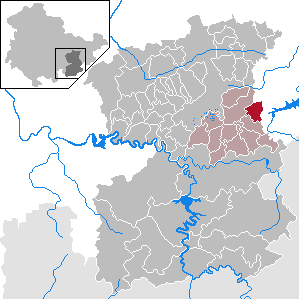
| Location of the municipality of Tegau in the Saale-Orla district | ||
  |
||


Tegau is a municipality in the Saale-Orla district in Thuringia . It is a member of the Lake District administrative community . The district of Burkersdorf belongs to Tegau .
geography
Tegau is on the main B2 road and is therefore easy to reach. The connection to Burkersdorf is also cheap. Both villages are located on an undulating, barely forested high plateau in the south-east Thuringian slate mountains. Most of the areas can be used for arable farming. Spring troughs and areas in streams are grassland locations.
geology
The soils in the slate mountains have a high proportion of fine earth and humus content and are very fertile under the climatic conditions in the Schleiz region.
Neighboring communities
Neighboring communities are: Dittersdorf , Göschitz and Pahren in the Saale-Orla district and Auma-Weidatal and Zeulenroda-Triebes in the Greiz district .
history
The place Tegau was founded by Sorbs . It is first mentioned in a document in 1397. W. Kahl recently records 1071.
The economy was and is shaped by agriculture. The large mill pond southeast of Tegau am Tegbach is reminiscent of the mill and the craft in Tegau. Master Heinrich Wolff , the Tegaumüller, was born around 1625 . This is the first documentary evidence of the watermill near the village. Until 1937 the mill used an overshot water wheel. The last miller then bought a water-powered turbine. After his death, the mill was sold several times and the milling operation was stopped.
On July 1, 1950, the previously independent community of Burkersdorf was incorporated.
Population development
Development of the population (December 31st each) :
|
|
|
|
|
Data source: Thuringian State Office for Statistics
religion
The place has a Protestant parish of 225 parishioners. The community belongs to the parish of Dittersdorf .
Attractions
The place is characterized by the St. Antonius Church. The first building of the church in the Gothic style disappeared for the most part when the church was rebuilt in the 17th and 18th centuries. It was at this time that the tower, which verifiably dates from the 13th century, received its baroque dome. Its tail dome is 41 m high. In 1870 the church was completely redesigned within 9 months, so that many elements of the neo-Gothic can be found today. There is still a Gothic entrance portal on the west gable.
economy
Hartsteinwerke Burgk GmbH & Co. OHG mines red and gray limestone in a quarry on the Vogelsberg south of the village, which was and is used for various purposes. Raw blocks, which were suitable for processing stone, were used as Saalburg marble .
Individual evidence
- ^ Population of the municipalities from the Thuringian State Office for Statistics ( help on this ).
- ↑ Manfred Graf: Organization of the cooperative plant production with a high proportion of grassland in the southeast Thuringian slate mountains. Shown at the KOG "Lobenstein". 1970, (Jena, University, dissertation, 1970; typed).
- ^ Wolfgang Kahl : First mention of Thuringian towns and villages. A manual. 5th, improved and considerably enlarged edition. Rockstuhl, Bad Langensalza 2010, ISBN 978-3-86777-202-0 , p. 282.
- ↑ Günter Steiniger: Mills on the Auma, the Triebes, the Leuba and in the Güldetal. With the mills on Kesselbach, Finkenbach, Pöllnitzbach, Struthbach, Floßbach and the Seebach. Rockstuhl, Bad Langensalza 2011, ISBN 978-3-86777-296-9 , pp. 206-209.
Web links
Bad Lobenstein | Bodelwitz | Dittersdorf | Döbritz | Dreitzsch | Eßbach | Gefell | Geroda | Gertewitz | Görkwitz | Göschitz | Gössitz | Grobengereuth | Hirschberg | Keila | Cherry chew | Kospoda | Krölpa | Langenorla | Lausnitz | Lemnitz | Löhma | Miesitz | Mittelpöllnitz | Moßbach | Moxa | Neundorf (near Schleiz) | Neustadt an der Orla | Nimritz | Oberoppurg | Oettersdorf | Oppurg | Paska | Peuschen | Plot | Pörmitz | Pößneck | Quaschwitz | Ranis | Remptendorf | Rosendorf | Rosenthal am Rennsteig | Saalburg-Ebersdorf | Schleiz | Lubricating seat | Schmorda | Schondorf | Seisla | Solkwitz | Tanna | Tegau | Tommelsdorf | Triptis | Volkmannsdorf | Weira | Wernburg | Wilhelmsdorf | Wurzbach | Ziegenrück