Dreitzsch
| coat of arms | Germany map | |
|---|---|---|

|
Coordinates: 50 ° 44 ' N , 11 ° 48' E |
|
| Basic data | ||
| State : | Thuringia | |
| County : | Saale-Orla district | |
| Management Community : | Triptis | |
| Height : | 310 m above sea level NHN | |
| Area : | 7.26 km 2 | |
| Residents: | 418 (Dec. 31, 2019) | |
| Population density : | 58 inhabitants per km 2 | |
| Postal code : | 07819 | |
| Area code : | 036481 | |
| License plate : | SOK, LBS, PN, SCZ | |
| Community key : | 16 0 75 019 | |
| Community structure: | 2 districts | |
| Association administration address: | Markt 1 07819 Triptis |
|
| Website : | ||
| Mayor : | Frank Salzmann | |
| Location of the Dreitzsch community in the Saale-Orla district | ||
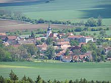
Dreitzsch is a municipality in the Saale-Orla district in Thuringia . It belongs to the Triptis administrative community .
geography
The community Dreitzsch is located in the eastern part of the Orlatales and consists of the districts Dreitzsch and Alsmannsdorf .
history
The name Dreitzsch comes from the Slavonic and means in a figurative sense "bump, crush, tear up", that is, reclaiming wasteland.
Dreitzsch was first mentioned in a document in 1120.
In the Dreitzsch corridor, during excavations in 1936, 1976 and 1979, an extensive fire burial field from the Hallstatt period and a Slavic body burial field from the early and high Middle Ages were uncovered by the Germanic Museum of the University of Jena and the Institute for Anthropology .
The district Alsmannsdorf, which was independent until 1956, only developed later from the Vorwerk of the Dreitzsch manor . This was converted into a state property in 1844 , which existed in the Soviet occupation zone until the land reform in 1945. A castle that had a major impact on the townscape was blown up in 1948 .
During the Second World War , 14 workers from Czechoslovakia , Poland and the Soviet Union had to do forced labor on six farms in the Alsmannsdorf district . The grave of a Polish forced laborer is in the cemetery.
Population development
Development of the population (December 31st each) :
|
|
|
|
|
- Data source: Thuringian State Office for Statistics
politics
coat of arms
The coat of arms was approved on October 11, 1993:
Blazon : “Half split and divided by red, silver and blue; at the top in front a silver vessel composed of shards, behind a red harp inclined to the right, at the bottom a silver stone bridge consisting of two arches, underneath a floating silver wave beam. "
In the coat of arms symbols of both districts appear. A field symbolizes the excavations found in the cremation graveyard. The harp in the second part refers to the district Alsmannsdorf, which in the historical seal carried a harp with a seated ducal crown; however, the importance of the harp is unknown. The historical arch bridge shown in the shield base (now a listed building) is located in the Dreitzsch district and once led over the Orla, which is symbolized by the wave beam.
The coat of arms was designed by Manfred Fischer from Goßwitz .
Attractions
- Listed stone bridge over the Orla in the Dreitzsch district
- Baroque Johanneskirche in Dreitzsch with original furnishings from 1703 (restored in 1993)
- Homesteads in Dreitzsch and Alsmannsdorf
- The village and local history museum, which has existed since 1998, illustrates the settlement history of the town hall and rural life over the past two centuries
Individual evidence
- ^ Population of the municipalities from the Thuringian State Office for Statistics ( help on this ).
- ↑ Thuringian Association of the Persecuted of the Nazi Regime - Association of Antifascists and Study Group of German Resistance 1933–1945 (Ed.): Local history guide to sites of resistance and persecution 1933–1945. Volume 8: Thuringia. VAS - Verlag für Akademische Schriften, Frankfurt am Main 2003, ISBN 3-88864-343-0 , p. 221.
- ↑ Hartmut Ulle: New Thuringian Wappenbuch. Volume 2: Ilmkreis, Jena, Kyffhäuserkreis, Saale-Orla-Kreis, Saalfeld-Rudolstadt (district), Schmalkalden-Meiningen (district), Suhl. 2nd, changed, revised edition. Working group Genealogy Thuringia, Erfurt 1997, ISBN 3-9804487-2-X , p. 35.


