Dobritz
| coat of arms | Germany map | |
|---|---|---|

|
Coordinates: 50 ° 42 ' N , 11 ° 38' E |
|
| Basic data | ||
| State : | Thuringia | |
| County : | Saale-Orla district | |
| Management Community : | Oppurg | |
| Height : | 260 m above sea level NHN | |
| Area : | 3.12 km 2 | |
| Residents: | 181 (Dec. 31, 2019) | |
| Population density : | 58 inhabitants per km 2 | |
| Postal code : | 07381 | |
| Area code : | 03647 | |
| License plate : | SOK, LBS, PN, SCZ | |
| Community key : | 16 0 75 016 | |
| Association administration address: | Am Türkenhof 5 07381 Oppurg |
|
| Mayor : | Hartmut Ortlepp | |
| Location of the municipality of Döbritz in the Saale-Orla district | ||
Döbritz is a municipality in the Saale-Orla district in Thuringia and is part of the Oppurg administrative community .
geography
The community is located in the Gamsental, below Döbritz Switzerland, a Zechstein reef area with 14 tower-like individual reefs, which arose 250 million years ago.
history
The Döbritz caves are located on the western edge of the Gamsental. The Zechstein massif has a number of caves in which Stone Age finds were made. In 1071 the community was first mentioned in a document as the Slavic village "Dobrawicz".
Origin of name
from Old / Church Slavonic добръ / dobrŭ ('efficient', 'beautiful', 'good')
church
Evangelical village church from 1768.
Population development
Development of the population (as of December 31st) :
|
|
|
|
|
- Data source: Thuringian State Office for Statistics
politics
Municipal council
The council of the community consists of 6 councilors and councilors.
- BI Döbritz 4 seats
- FFW 2 seats
(Status: local elections on June 27, 2004)
coat of arms
The coat of arms was approved on October 1, 1991.
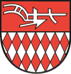
Blazon : “Divided; at the top a silver plow in red, at the bottom roughened vertically in silver and red. "
Döbritz has significant prehistoric finds. The two most important examples in terms of cultural history are a harpoon tip and the so-called sole idol. The two found objects, which are around 130,000 years old, have decorations in a diamond-like shape. This results in a diamond field as a herald figure. A house brand of a historical building in the town in the form of a plow forms the second coat of arms element. It also refers to the agricultural history of the place.
The coat of arms was designed by the heraldists Frank Jung and Frank Diemar .
traffic
Döbritz is connected to the road network via the federal highway 281 . However, it can also be reached from Gertewitz and Bodelwitz.
Individual evidence
- ^ Population of the municipalities from the Thuringian State Office for Statistics ( help on this ).
- ^ Otto Dobencker : Regesta diplomatica necnon epistolaria historiae Thuringiae. Volume 1: (c. 500-1152). Fischer, Jena 1896, no.893 .
- ^ Franz Stroh: The old Slavic settlement. Retrieved May 29, 2019 .
- ↑ Heinrich Tischner: Eymologie - Languages - alto, Church Slavonic. Retrieved February 17, 2020 .
- ↑ Hartmut Ulle: New Thuringian Wappenbuch. Volume 2: Ilmkreis, Jena, Kyffhäuserkreis, Saale-Orla-Kreis, Saalfeld-Rudolstadt (district), Schmalkalden-Meiningen (district), Suhl. 2nd, changed, revised edition. Arbeitsgemeinschaft Genealogy Thüringen eV, Erfurt 1997, ISBN 3-9804487-2-X , p. 34.


