
Lausnitz
| coat of arms | Germany map | |
|---|---|---|

|
Coordinates: 50 ° 44 ' N , 11 ° 43' E |
|
| Basic data | ||
| State : | Thuringia | |
| County : | Saale-Orla district | |
| Management Community : | Oppurg | |
| Height : | 284 m above sea level NHN | |
| Area : | 8.55 km 2 | |
| Residents: | 302 (Dec. 31, 2019) | |
| Population density : | 35 inhabitants per km 2 | |
| Postal code : | 07806 | |
| Area code : | 036481 | |
| License plate : | SOK, LBS, PN, SCZ | |
| Community key : | 16 0 75 056 | |
| Association administration address: | Am Türkenhof 5 07381 Oppurg |
|
| Website : | ||
| Mayor : | Wolfgang Ritter | |
| Location of the municipality Lausnitz in the Saale-Orla district | ||
  |
||

Lausnitz (also Lausnitz b. Neustadt an der Orla ) is a municipality in the administrative community of Oppurg in the Saale-Orla district in Thuringia .
geography
Lausnitz is located near Neustadt an der Orla and is the immediate neighboring village of Kolba, a little to the west, and the northeastern manor Positz . The community is located in the Orlatal the southern foothills of the northern red sandstone foothills of the Thuringian Slate Mountains. The federal road 281 leads a few hundred meters south of the village. After the road, the Leipzig – Saalfeld / Saale railway follows . The area around the village is docked and has sand, loess and clay soils. Ponds loosen up the corridor, which is bordered in the north by the forest towards Langendembach .
history
The first documentary mention of Lausnitz was on June 8, 1266. Lausnitz belonged to the Electoral Saxon Office of Arnshaugk until 1815 and after its assignment, decided at the Congress of Vienna , came with most of the Neustädter Kreis to the Grand Duchy of Saxony-Weimar-Eisenach .
At least since the 15th century, there were Lausnitz estates : to 1945 more than 200 years in the family of Wurmb , before 250 years owned by the family of stone . The “Untere Hof” had a manor house called the “castle” in the village , with rococo furniture, a collection of Meissen porcelain and a valuable library. This included a park in the style of the Bayreuther Hof. The last male owner, the farmer Lutze von Wurmb, fell as an officer in the Second World War in 1943. Although the family had been classified as “anti-fascist” in the Soviet Zone , the widow with three children was expropriated without compensation in autumn 1945 and expelled from her property. When Frau von Wurmb was threatened with arrest, she and the children fled to West Germany in December 1945. When the (in 1945 15-year-old) daughter Maria von Below (born von Wurmb) was back in Lausnitz after the fall of the 1990s, she described her experiences as follows: “Lands and buildings have deteriorated, art treasures, furniture and stolen pictures ”.
Population development
Development of the population (as of December 31st) :
|
|
|
|
|
- Data source: Thuringian State Office for Statistics
Attractions
- Village church with a memorial on the church wall for those who died in both world wars and with a plaque “Dedicated to the victims of Stalinism and the SED regime. Our teacher Kurt Förster died in the Buchenwald internment camp in 1947. Roland Scholz was shot dead on March 31, 1956 at the sector border in Berlin ”.
- Former manor buildings in a desolate condition
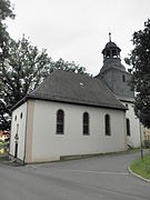
church

Memorial plaque on the church wall

Manor house


Individual evidence
- ^ Population of the municipalities from the Thuringian State Office for Statistics ( help on this ).
- ↑ Main Statute ( Memento from September 23, 2016 in the Internet Archive )
- ^ Thuringian State Office for Statistics: Municipality: Lausnitz b. Neustadt an der Orla
- ↑ Municipal directory of the statistical offices of the federal and state governments ( Memento from March 4, 2016 in the Internet Archive )
- ^ Wolfgang Kahl : First mention of Thuringian towns and villages. A manual. 5th, improved and considerably enlarged edition. Rockstuhl, Bad Langensalza 2010, ISBN 978-3-86777-202-0 , p. 159.
- ↑ Maria von Below (born von Wurmb): The land reform in the Soviet zone, as I experienced it. In: Bruno J. Sobotka (Ed.): Castles, palaces, manor houses in Thuringia. Photographs by Jürgen Strauss. Theiss, Stuttgart 1995, ISBN 3-8062-1123-X , pp. 168-171.
Web links
Bad Lobenstein | Bodelwitz | Dittersdorf | Döbritz | Dreitzsch | Eßbach | Gefell | Geroda | Gertewitz | Görkwitz | Göschitz | Gössitz | Grobengereuth | Hirschberg | Keila | Cherry chew | Kospoda | Krölpa | Langenorla | Lausnitz | Lemnitz | Löhma | Miesitz | Mittelpöllnitz | Moßbach | Moxa | Neundorf (near Schleiz) | Neustadt an der Orla | Nimritz | Oberoppurg | Oettersdorf | Oppurg | Paska | Peuschen | Plot | Pörmitz | Pößneck | Quaschwitz | Ranis | Remptendorf | Rosendorf | Rosenthal am Rennsteig | Saalburg-Ebersdorf | Schleiz | Lubricating seat | Schmorda | Schondorf | Seisla | Solkwitz | Tanna | Tegau | Tommelsdorf | Triptis | Volkmannsdorf | Weira | Wernburg | Wilhelmsdorf | Wurzbach | Ziegenrück