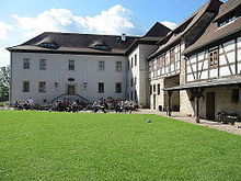
Positz manor
The building complex of the former Positz manor stands north of the Kolba district of the Oppurg municipality just before the forest area in the direction of Langendembach in the Saale-Orla district in Thuringia .
history
In 1769 the property became the property of Count Hoym when it was bought by the Brandenstein brothers . Accordingly, the Vorwerk must have already existed, because it was mentioned in a document as early as 1452.
In Kolba in 1923 the tenant Olga Heitsch managed the manor of Prince Christian Kraft zu Hohenlohe-Oehringen with 190 hectares of operating area. After the Second World War , it was expropriated and the land and the living and dead inventory were transferred to resettlers and poor farmers. The Positz Vorwerk existed from this time as a public property . It managed 135 hectares of land that had been handed over from the land reform fund . In 1960 the first LPG was founded in the village of Kolba. After that, the development of agriculture in the Orlatal took its course up to the Agricultural Industry Association (AIV). The VEG Positz was still a traditional unit (land, buildings, animals and experienced agricultural workers) with a good level of income from 1945 to around 1960.
The areas were then transferred to plant production to form the AIV and the stables were used for animal production. When the production unit was abandoned, the buildings began to decline.
The turning point was luck and a blessing for the natural property. It was privatized and financially supported by the monument office in the reconstruction of the four-sided courtyard . Today it is a popular country hotel with a knightly character.
Web links
- Website of the Rittergut Positz GmbH. Retrieved May 12, 2020 .
- Positz manor. In: German Foundation for Monument Protection . Retrieved May 12, 2020 .
Individual evidence
- ↑ History of the Positz Manor. In: Website of the Rittergut Positz GmbH. Retrieved May 12, 2020 .
- ^ Wolfgang Kahl : First mention of Thuringian towns and villages. A manual. Verlag Rockstuhl, Bad Langensalza, 2010, ISBN 978-3-86777-202-0 , p. 223.
- ↑ Jürgen Gruhle : Black Book of Land Reform. Contained communities and places - Thuringia ( Memento from May 3, 2010 in the Internet Archive )
Coordinates: 50 ° 43 ′ 50.7 " N , 11 ° 40 ′ 23.6" E
