
Oppurg
| coat of arms | Germany map | |
|---|---|---|

|
Coordinates: 50 ° 43 ' N , 11 ° 39' E |
|
| Basic data | ||
| State : | Thuringia | |
| County : | Saale-Orla district | |
| Management Community : | Oppurg | |
| Height : | 230 m above sea level NHN | |
| Area : | 15.8 km 2 | |
| Residents: | 1126 (Dec. 31, 2019) | |
| Population density : | 71 inhabitants per km 2 | |
| Postal code : | 07381 | |
| Area code : | 03647 | |
| License plate : | SOK, LBS, PN, SCZ | |
| Community key : | 16 0 75 077 | |
| LOCODE : | DE OPG | |
| Community structure: | 3 districts | |
| Address of the municipal administration: |
Hauptstrasse 6 07381 Oppurg |
|
| Website : | ||
| Mayor : | Heiko Schoberth ( CDU ) | |
| Location of the municipality of Oppurg in the Saale-Orla district | ||
  |
||


Oppurg is a municipality in the Saale-Orla district in Thuringia and the seat of the Oppurg administrative community, which consists of 13 municipalities .
geography
The Orla flows through the village of Oppurg . The Oppurg field marrow is docked and the soils are very different. There are loess, sand and clay locations. Ponds loosen up the hallway.
Community structure
The municipality of Oppurg, located on the little river Orla, consists of the three districts of Oppurg, Rehmen and Kolba .
Neighboring communities
Neighboring communities are Döbritz , Langenorla , Lausnitz , Nimritz , Oberoppurg , the city of Pößneck , Solkwitz and Weira .
history
A prehistoric and early historical settlement of the Orlatal can be proven with the finds recovered not far from Oppurg on the rugged Zechstein reef. Archaeological finds from the Paleolithic , the Bronze and Early Iron Ages and also from the Migration Period were found there . At the location of located there today castle Oppurg previously occupied by a water castle . It probably came from the Middle Ages. It is said to have been built in 1074 by Margrave Wiprecht von Groitzsch . Remains of the tower and wall are still there. In 1354 the Knight von Brandenstein redesigned the castle. The current castle was built between 1705 and 1708.
Oppurg was first mentioned in a document in December 1074 as Opult . On May 1, 1323 Kolba and 1350 Rehmen were first mentioned. In 1545, after his return from Turkish captivity, Hans von Brandenstein built the Turkish court. Before that, there was a fortification protected by a moat on the grounds of the Turkish court. It was certainly a medieval manor house. The Türkenhof is a successor building in which remains of the old manor house are still present.
From 1680 until the reorganization of the Ernestine rule in 1826, all three places belonged to Saxony-Saalfeld . Then they belonged to the Saalfeld district of the Duchy of Saxony-Meiningen until 1920 and then to the newly formed state of Thuringia. As a result of the administrative reform in 1952, the places came to the Gera district until 1990 .
In 1871 the railway reached Oppurg, and in 1912 electricity reached Oppurg as well as Kolba and Rehmen.
Incorporations
The municipality of Oppurg was created in its present form in 1965 through the merger of the three previously independent villages of Oppurg, Kolba and Rehmen, after their agricultural production cooperatives had been merged a year earlier .
Rehmen was originally incorporated into Pößneck in October 1923, but this administrative process was reversed in 1924 as a result of strong public protests.
Population development
In 1933 Oppurg had 738, Kolba 428 and Rehmen 315 inhabitants. In 1939 the population was 759, 397 and 336 respectively.
Development of the population (as of December 31st) :
|
|
|
|
|
- Data source: Thuringian State Office for Statistics
politics
Municipal council
Since the 2014 municipal council election , the municipal council has been composed as follows:
mayor
In the mayoral elections on June 5, 2016, Heiko Schoberth (CDU) prevailed with 95.7% of the votes in the first ballot.
coat of arms

A gray two-arched stone bridge spans a blue corrugated shield base. Above it is a golden sun in the front and a green deciduous tree with a brown trunk in the back.
This bridge really does exist and is a landmark of Oppurg. It crosses the Orla river from the village square .
Culture and sights
Buildings
- The sights of the municipality include u. a. the baroque Oppurg Castle from the 18th century (built from 1708 to 1714). The previous building was a moated castle on the Orla, the construction of which dates back to the 11th century. The castle has 365 windows, 52 doors inside, 12 chimneys and 4 entrances - for this reason it is often called the four seasons castle . The castle is now managed by the Christian Youth Village Association in Germany and was used as a conference venue until 2017 .
- Evangelical Church in Oppurg , also restored with funds from the German Foundation for Monument Protection
- Türkenhaus - so called because the prince's son did not return home until long after the war against the Turks had ended and no one knew whether it was really him and whether it was built for him - Hans the Turk
- A post- mile pillar from the Electorate of Saxony from the 18th century has been preserved in Oppurg from the former post route to Saalfeld .
- Church in Rehmen with high defensive wall
- Church in Kolba
- War memorial in Kolba: “In memory of the victims of wars and tyranny”. The crowning eagle shows multiple bullet holes from handguns from the first occupation in 1945.
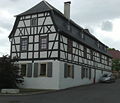
The Käthenhof in Oppurg is one of the oldest residential buildings
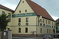
The Grüner Baum Oppurg restaurant in the center of the village is a popular restaurant in the region

The church in Rehmen


Historical monuments
In the cemetery, the grave monuments of six concentration camp prisoners , who were shot by SS men in April 1945, commemorate the death march of the prisoners of the Buchenwald concentration camp . In 1985 a stele was erected in the village as a warning.
Economy and Infrastructure
In 1923 the tenant Olga Heitsch managed the manor of Prince Christian Kraft zu Hohenlohe-Oehringen with 190 hectares of land in the incorporated village of Kolba . After 1945 the Vorwerk "Positz" and areas of the property in the amount of 135 hectares were transferred to the aforementioned public property through the land reform. This estate was headed by the gentlemen: Mende, Horschke, Graf and Lützsche. In the period 1945 - around 1960 this company was still a traditional stable unit (land, buildings, animals and experienced workers) with a good level of income. The Höhenfleck cattle herd produced 5,500 kg per year with 3.5% fat per cow. The areas were then transferred to plant production to form the AIV and the stables were used for animal production. With the abandonment of the “manor” production unit, the buildings began to fall into disrepair. Since 1997 Gut Positz has been renovated piece by piece by private hands. In addition to the ancient tavern, seminar rooms, several large halls, overnight accommodation and a wellness area have been created.
traffic

Oppurg is just off the touristy than Thuringian Porcelain Route -run state road 281 , about 15 km from the motorway 9 removed. The Thuringian state road 2359 connects Oppurg with Ziegenrück . The municipality also lies on the railway line Leipzig-Gera-Saalfeld , the station holding the regional train - and the regional express trains. Between 1892 and 1946 the trains on the Orlamünde – Oppurg railway also ran from here .
The 34 km long Orla Cycle Path , which follows the entire course of the Orla, has been running through Oppurg since 2005 .
Established businesses

In the industrial park southeast of Oppurg, GGP Media , a subsidiary of the Bertelsmann Group, has set up its printing presses in a former building materials trading hall and produces books like in the main plant in Pößneck . Right next to it is the premises of the logistics partner L&T. Furthermore, there are other trading companies here. In the 1950s, as everywhere in the GDR, large agricultural companies were founded under duress: the Agricultural Production Cooperative , or LPG for short. In the 1970s, this specialized in animal LPG (T) and plant production LPG (P). After the fall of the Wall , the rural cooperative, which still exists today, was created, which continues to use the favorable climatic and local conditions.
Personalities
- Christoph Sonntag (1654–1717), Protestant theologian, pastor in Oppurg from 1675 to 1680
Individual evidence
- ^ Population of the municipalities from the Thuringian State Office for Statistics ( help on this ).
- ↑ Michael Köhler : Pagan sanctuaries. Pre-Christian places of worship and suspected cult sites in Thuringia. Jenzig-Verlag Köhler, Jena 2007, ISBN 978-3-910141-85-8 , p. 136.
- ↑ Thomas Bienert: Medieval castles in Thuringia. Wartberg Verlag, Gudensberg-Gleichen 2000, ISBN 3-86134-631-1 , p. 218.
- ↑ Michael Köhler: Thuringian castles and fortified prehistoric and early historical living spaces. Jenzig-Verlag Köhler, Jena 2001, ISBN 3-910141-43-9 , p. 104.
- ^ Wolfgang Kahl : First mention of Thuringian towns and villages. A manual. 5th, improved and considerably enlarged edition. Rockstuhl, Bad Langensalza 2010, ISBN 978-3-86777-202-0 , pp. 213, 150 and 228.
- ↑ Michael Köhler: Thuringian castles and fortified prehistoric and early historical living spaces. Jenzig-Verlag Köhler, Jena 2001, ISBN 3-910141-43-9 , p. 252.
- ^ History of the municipality of Oppurg ( Memento from September 10, 2012 in the web archive archive.today )
- ^ Michael Rademacher: German administrative history from the unification of the empire in 1871 to the reunification in 1990. Saalfeld district. (Online material for the dissertation, Osnabrück 2006).
- ↑ http://www.wahlen.thueringen.de/datenbank/wahl1/wahl.asp?wahlart=GW&wjahr=2014&habenErg=GEM&wknr=075&gemnr=75077
- ↑ http://www.wahlen.thueringen.de/datenbank/wahl1/wahl.asp?wahlart=GW&wjahr=2009&habenErg=GEM&wknr=075&gemnr=75077
- ↑ Thuringian Association of the Persecuted of the Nazi Regime - Association of Antifascists and Study Group of German Resistance 1933–1945 (Ed.): Local history guide to sites of resistance and persecution 1933–1945. Volume 8: Thuringia. VAS - Verlag für Akademische Schriften, Frankfurt am Main 2003, ISBN 3-88864-343-0 , p. 225.
- ↑ Jürgen Gruhle : Black Book of Land Reform. Contained communities and places - Thuringia ( Memento from May 3, 2010 in the Internet Archive )
- ↑ Kolba Manor
Web links
- Website of the administrative association Oppurg. Retrieved May 13, 2020 .
Bad Lobenstein | Bodelwitz | Dittersdorf | Döbritz | Dreitzsch | Eßbach | Gefell | Geroda | Gertewitz | Görkwitz | Göschitz | Gössitz | Grobengereuth | Hirschberg | Keila | Cherry chew | Kospoda | Krölpa | Langenorla | Lausnitz | Lemnitz | Löhma | Miesitz | Mittelpöllnitz | Moßbach | Moxa | Neundorf (near Schleiz) | Neustadt an der Orla | Nimritz | Oberoppurg | Oettersdorf | Oppurg | Paska | Peuschen | Plot | Pörmitz | Pößneck | Quaschwitz | Ranis | Remptendorf | Rosendorf | Rosenthal am Rennsteig | Saalburg-Ebersdorf | Schleiz | Lubricating seat | Schmorda | Schondorf | Seisla | Solkwitz | Tanna | Tegau | Tommelsdorf | Triptis | Volkmannsdorf | Weira | Wernburg | Wilhelmsdorf | Wurzbach | Ziegenrück