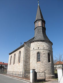
Peuschen
| coat of arms | Germany map | |
|---|---|---|

|
Coordinates: 50 ° 40 ′ N , 11 ° 39 ′ E |
|
| Basic data | ||
| State : | Thuringia | |
| County : | Saale-Orla district | |
| Management Community : | Ranis-Ziegenrück | |
| Height : | 470 m above sea level NHN | |
| Area : | 7.55 km 2 | |
| Residents: | 454 (Dec. 31, 2019) | |
| Population density : | 60 inhabitants per km 2 | |
| Postal code : | 07389 | |
| Area code : | 03647 | |
| License plate : | SOK, LBS, PN, SCZ | |
| Community key : | 16 0 75 081 | |
| Community structure: | 3 districts | |
| Association administration address: | Pößnecker Str. 2 07389 Ranis |
|
| Website : | ||
| Mayor : | Stefan Fröhlich | |
| Location of the municipality of Peuschen in the Saale-Orla district | ||
Peuschen is a municipality in the Ranis-Ziegenrück administrative community in the Saale-Orla district in Thuringia . The districts of Peuschen, Bahren and Laskau belong to the community .
history
Peuschen was first mentioned in a document in 1408. In 1795, the Schulze Johann Müller from Laskau built a residential and farm building in the middle of his fields, which formed the origin of the later village of Peuschen. In the following 60 years 76 mostly one-story houses were built, which were inhabited by day laborers and industrial workers. On July 17, 1876, Peuschen received official recognition as a community. Until 1815, Peuschen and Laskau belonged to the administrative office of Arnshaugk , Bahren to the administrative office of Ziegenrück . After the cession of the Neustädter Kreis and its offices, decided at the Congress of Vienna in 1815, Peuschen and Bahren belonged to the Prussian district of Ziegenrück until 1945 , Laskau to the Grand Duchy of Saxony-Weimar-Eisenach and from 1920 to the state of Thuringia.
Incorporations
Laskau has been part of the Peuschen community since 1974 and Bahren since 1994.
Population development
Development of the population (from 1994: as of December 31) :
|
|
|
|
|
- Data source from 1994: Thuringian State Office for Statistics
politics
mayor
In June 2016, Stefan Fröhlich was elected mayor.
coat of arms
The coat of arms was approved on May 29, 1996 by the Thuringian State Administration.
Blazon : “Divided by silver and green; A black, golden-armored eagle growing above, below three silver linden leaves set in a three-pass. "
Along with other mighty deciduous trees, the linden tree is the defining feature of the three districts. The union of the linden leaves in the coat of arms symbolizes the togetherness of the three districts, while the eagle refers to the former Prussian sovereignty of the districts of Peuschen and Bahren.
The coat of arms was designed by Manfred Fischer from Goßwitz .
Web links
Individual evidence
- ^ Population of the municipalities from the Thuringian State Office for Statistics ( help on this ).
- ^ Wolfgang Kahl : First mention of Thuringian towns and villages. A manual. 5th, improved and considerably enlarged edition. Rockstuhl, Bad Langensalza 2010, ISBN 978-3-86777-202-0 , p. 217.
- ^ A b Michael Rademacher: German administrative history from the unification of the empire in 1871 to the reunification in 1990. Ziegenrück district. (Online material for the dissertation, Osnabrück 2006).
- ↑ http://wahlen.thueringen.de/datenbank/wahl1/wahl.asp?wahlart=BM&wJahr=0000&zeigeErg=GEM&auswertung=1&wknr=075&gemnr=75081&terrKrs=&gemteil=000&buchstabe=&Langname=&wahlvorschlag=&sort=&druck=&XLS=&anzahlH=- 5 & Non_existing = & x_vollbildDatteil = & optik = & aktuell = & ShowLand = & ShowWK = & ShowPart = & w_date = 05.06.2016
- ↑ Hartmut Ulle: New Thuringian Wappenbuch. Volume 2: Ilmkreis, Jena, Kyffhäuserkreis, Saale-Orla-Kreis, Saalfeld-Rudolstadt (district), Schmalkalden-Meiningen (district), Suhl. 2nd, changed, revised edition. Working group Genealogy Thuringia, Erfurt 1997, ISBN 3-9804487-2-X , p. 41.


