
Dittersdorf (Thuringia)
| coat of arms | Germany map | |
|---|---|---|
 Help on coat of arms |
Coordinates: 50 ° 39 ' N , 11 ° 49' E |
|
| Basic data | ||
| State : | Thuringia | |
| County : | Saale-Orla district | |
| Management Community : | Lake district | |
| Height : | 490 m above sea level NHN | |
| Area : | 15.67 km 2 | |
| Residents: | 464 (Dec. 31, 2019) | |
| Population density : | 30 inhabitants per km 2 | |
| Postal code : | 07907 | |
| Area code : | 036648 | |
| License plate : | SOK, LBS, PN, SCZ | |
| Community key : | 16 0 75 014 | |
| Community structure: | 5 districts | |
| Association administration address: | Schleizer Str. 17 07907 Oettersdorf |
|
| Website : | ||
| Mayor : | Andreas Schmidt ( CDU ) | |
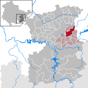
| Location of the community of Dittersdorf in the Saale-Orla district | ||
  |
||


Dittersdorf is a municipality in the Saale-Orla district in Thuringia and part of the Lake District administrative community .
geography
location
The village is located on the eastern edge of the Plothener Teiche area . The state roads L 1077 from Schleiz to Neustadt Orla and L 2349 from Tegau to Plothen lead through the village . The federal motorway 9 passes to the west of or in the area surrounding the town . To the north of the town there is a forest area in the district. The places Dittersdorf and Dragensdorf are located on a slightly elevated plateau in the south-eastern Thuringian Slate Mountains .
Community structure
The political municipality of Dittersdorf has five districts:
|
Neighboring communities
Neighboring communities are: Pörmitz , Pahnstangen , Plothen , Moßbach and Tömmelsdorf .
geology
Geologically, the districts of the villages are in the southeast Thuringian slate mountains. These soils are very fertile due to the high proportion of fine soil and the high humus content.
history
Dittersdorf was first officially registered on December 5, 1297 and Dragensdorf between 1274 and 1283.
In 1923 the tenant Constantin Übel managed the domain of Prince Reuss Younger Line with an agricultural area of 192 hectares. After the Second World War, the property was expropriated and divided among farmers and resettlers. After that the farmers went the successful way of agriculture in East Germany. After the fall of the Wall, new forms of cooperation were found or reinstatements were made.
Incorporations
On December 1, 2010, the previously independent municipality of Dragensdorf was incorporated into Dittersdorf. On December 31, 2013, the previously independent community of Chursdorf with the districts of Sorna and Waldhäuser was incorporated into Dittersdorf.

Population development
Development of the population (December 31st each) :
|
|
|
|
|
- Data source: Thuringian State Office for Statistics
politics
Municipal council
Since the local elections on May 25, 2014, the Dittersdorf municipal council has consisted of 6 members:
- CDU : 3 community representatives, all living in the Chursdorf district
- SG Dittersdorf 72 eV: 2 community representatives, both living in the Dittersdorf district
- Fire brigade association Dragensdorf: 1 community representative, living in the Dragensdorf district
mayor
In November 1997 Andreas Schmidt (CDU) was elected, he was re-elected in 1999, 2004, 2010 and 2016.
Economy and Infrastructure
The economy was and is characterized by agriculture. In addition, the district of Dittersdorf has an industrial park with an area of 7.32 hectares. Important local companies in the municipality are:
- Landgenossenschaft Dittersdorf eG, agriculture (142 employees)
- RK Landschaftsbau Dittersdorf GmbH, landscaping (69 employees)
- HVT Hobelspanverarbeitung GmbH, wood processing (41 employees)
- Befomas GmbH, mechanical engineering
Thanks to a citizens' initiative, fast broadband connections have been available in Dittersdorf and Dragensdorf since November 2007.
traffic
The municipality has its own junction on federal motorway 9.
The district of Dittersdorf has had a bypass road since 2013. The "cow traffic light" built with this construction project was reported nationwide.
Web links
Individual evidence
- ^ Population of the municipalities from the Thuringian State Office for Statistics ( help on this ).
- ↑ Manfred Graf: Organization of the cooperative plant production with a high proportion of grassland in the southeast Thuringian slate mountains. Shown at the KOG "Lobenstein". 1970, (Jena, University, dissertation, 1970; typed).
- ^ Wolfgang Kahl : First mention of Thuringian towns and villages. A manual. 5th, improved and considerably enlarged edition. Rockstuhl, Bad-Langensalza 2010, ISBN 978-3-86777-202-0 , pp. 52 and 60.
- ^ Jürgen Gruhle : Black Book of Land Reform - Thuringia. Queryed on June 18, 2011 on the Internet
- ↑ StBA: Area changes from January 01 to December 31, 2010
- ↑ Confirmation from the state parliament on the Thuringian law on the voluntary reorganization of municipalities belonging to the district in 2013
- ↑ according to Election results for the 2014 local elections Thuringia p. 186, accessed on July 10, 2014 Archive link ( Memento from July 14, 2014 in the Internet Archive ) (PDF; 7.7 MB)
- ^ Result of the mayoral election on June 5, 2016
- ^ Dittersdorf industrial area Website of the administrative association. Retrieved January 16, 2014
- ↑ according to Information on the number of employees in the 2012 annual financial statements accessed in the Federal Gazette on January 16, 2014 archive link ( Memento from January 16, 2014 in the Internet Archive )
- ↑ DSL citizens' initiative for 036,648 ( Memento of 16 May 2016 Internet Archive ).
- ↑ Report on Kuh-Ampel ( Memento from November 13, 2013 in the Internet Archive )
Bad Lobenstein | Bodelwitz | Dittersdorf | Döbritz | Dreitzsch | Eßbach | Gefell | Geroda | Gertewitz | Görkwitz | Göschitz | Gössitz | Grobengereuth | Hirschberg | Keila | Cherry chew | Kospoda | Krölpa | Langenorla | Lausnitz | Lemnitz | Löhma | Miesitz | Mittelpöllnitz | Moßbach | Moxa | Neundorf (near Schleiz) | Neustadt an der Orla | Nimritz | Oberoppurg | Oettersdorf | Oppurg | Paska | Peuschen | Plot | Pörmitz | Pößneck | Quaschwitz | Ranis | Remptendorf | Rosendorf | Rosenthal am Rennsteig | Saalburg-Ebersdorf | Schleiz | Lubricating seat | Schmorda | Schondorf | Seisla | Solkwitz | Tanna | Tegau | Tommelsdorf | Triptis | Volkmannsdorf | Weira | Wernburg | Wilhelmsdorf | Wurzbach | Ziegenrück