
Paska
| coat of arms | Germany map | |
|---|---|---|

|
Coordinates: 50 ° 37 ' N , 11 ° 38' E |
|
| Basic data | ||
| State : | Thuringia | |
| County : | Saale-Orla district | |
| Management Community : | Ranis-Ziegenrück | |
| Height : | 440 m above sea level NHN | |
| Area : | 6.6 km 2 | |
| Residents: | 100 (Dec. 31, 2019) | |
| Population density : | 15 inhabitants per km 2 | |
| Postal code : | 07381 | |
| Area code : | 036483 | |
| License plate : | SOK, LBS, PN, SCZ | |
| Community key : | 16 0 75 079 | |
| Association administration address: | Pößnecker Str. 2 07389 Ranis |
|
| Mayor : | Tino Riemschneider (independent) | |
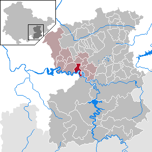
| Location of the municipality of Paska in the Saale-Orla district | ||
  |
||

Paska is a municipality in the Saale-Orla district in Thuringia , which is part of the Ranis-Ziegenrück administrative community . The place is in close proximity to the Hohenwarte reservoir .

history
The foundation of the village of Paska probably dates back to the 13th century . The place was first mentioned in documents in 1378. In the 16th and 17th centuries it was called Passeck . Archaeological excavations proved by grave finds the settlement of the Celts in the area around the place. The place belonged to the electoral office of Ziegenrück until 1815 and after its assignment, decided at the Congress of Vienna , came to the Prussian district of Ziegenrück , to which the place belonged until 1945.
Paska is a rural village . The typical old farms with their three and four-sided courtyards are mostly half-timbered buildings. The village is on the edge of the Sormitzgrund nature reserve .
Population development
Development of the population (from 1994: as of December 31) :
|
|
|
|
|
- Data source from 1994: Thuringian State Office for Statistics
religion
43.3% of the population are Protestant, 2.5% Catholic. The St. Martin Church of the Lutheran parish of Paska, built in 1716, belongs to the parish association Gössitz - Wernburg in the Schleiz parish of the Evangelical Church in Central Germany . The few Catholics are assigned to the parish of St. Josef based in Pößneck , Diocese of Erfurt , whose nearest church is St. Elisabeth in Ranis .
politics
mayor
Tino Riemschneider was elected mayor in June 2010 and re-elected in June 2016.
elections
In the 2019 European elections , Alternative für Deutschland (AfD) in Paska achieved the highest election result since it was founded in Germany with 51.7%. In the state elections in 2019 , the party received by far the highest share of votes in Thuringia in the municipality with 62.7% of the state votes (and 64.4% for the constituency candidate Heiko Bergner ).
Culture and sights

Historical monuments
In the cemetery, the grave monuments of four shot prisoners are reminiscent of the death march from the Buchenwald concentration camp , which was driven through the town by SS troops in April 1945 .
Transport links
A road leads through the village to Linkenmühle . From there it has been possible to cross the Saale with a car ferry since 1995 . The Nuremberg trade route used to run through the town .
Web links
Individual evidence
- ^ Population of the municipalities from the Thuringian State Office for Statistics ( help on this ).
- ^ Wolfgang Kahl : First mention of Thuringian towns and villages. A manual. 5th, improved and considerably enlarged edition. Rockstuhl, Bad Langensalza 2010, ISBN 978-3-86777-202-0 , p. 216.
- ^ A b Michael Rademacher: German administrative history from the unification of the empire in 1871 to the reunification in 1990. Ziegenrück district. (Online material for the dissertation, Osnabrück 2006).
- ↑ 2011 census
- ↑ http://wahlen.thueringen.de/datenbank/wahl1/wahl.asp?wahlart=BM&wJahr=0000&zeigeErg=GEM&auswertung=1&wknr=075&gemnr=75079&terrKrs=&gemteil=000&buchstabe=&Langname=&wahlvorschlag=&sort=&druck=&XLS=&anzahlH=- 6 & Non_existing = & x_vollbildDatteil = & optik = & aktuell = & ShowLand = & ShowWK = & ShowPart = & w_date = 06.06.2010
- ^ Elections in Thuringia. Retrieved June 23, 2019 .
- ↑ https://wahlen.thueringen.de/datenbank/wahl1/wahl.asp?wahlart=LW&wjahr=2019&habenErg=GEM&wknr=034&gemnr=75079
- ↑ Results of the state elections 2019 on thueringer-allgemeine.de; accessed on October 28, 2019
- ↑ Thuringian Association of the Persecuted of the Nazi Regime - Association of Antifascists and Study Group of German Resistance 1933–1945 (Ed.): Local history guide to sites of resistance and persecution 1933–1945. Volume 8: Thuringia. VAS - Verlag für Akademische Schriften, Frankfurt am Main 2003, ISBN 3-88864-343-0 , p. 225 f.
Bad Lobenstein | Bodelwitz | Dittersdorf | Döbritz | Dreitzsch | Eßbach | Gefell | Geroda | Gertewitz | Görkwitz | Göschitz | Gössitz | Grobengereuth | Hirschberg | Keila | Cherry chew | Kospoda | Krölpa | Langenorla | Lausnitz | Lemnitz | Löhma | Miesitz | Mittelpöllnitz | Moßbach | Moxa | Neundorf (near Schleiz) | Neustadt an der Orla | Nimritz | Oberoppurg | Oettersdorf | Oppurg | Paska | Peuschen | Plot | Pörmitz | Pößneck | Quaschwitz | Ranis | Remptendorf | Rosendorf | Rosenthal am Rennsteig | Saalburg-Ebersdorf | Schleiz | Lubricating seat | Schmorda | Schondorf | Seisla | Solkwitz | Tanna | Tegau | Tommelsdorf | Triptis | Volkmannsdorf | Weira | Wernburg | Wilhelmsdorf | Wurzbach | Ziegenrück